Effects of Synoptic Surveillance on model forecasts for
17 November 1999 0600 UTC
LENNY.
QuickTime movie of DLM wind model
forecasts
QuickTime movie of DLM wind data
increments
| TRACK (km) | ||||||||||||||||||||||||||||||||||||||||||||||||||||||||||||||||||||||||||||||||||||||||||||||||||||||||||||||||||||||||||||||||||||||||||||||||||||||||||||||||||||||||||||||||||||||||||||||||||||||||||||||||||||||||||||||||||||||||||||
| MODEL | 12 h | 24 h | 36 h | 48 h | 60 h | 72 h | 84 h | 96 h | 108 h | 120 h
|
| AVNN | 217. | 236. | 287. | 319. | 385. | 599. | 848. | 948. | 930. | 1047.
| AVAL | 116. | 131. | 206. | 228. | 369. | 544. | 746. | 771. | 786. | 955.
| %IMP | 47% | 44% | 28% | 29% | 4% | 9% | 12% | 19% | 18% | 9%
|
| GFNO | 85. | 99. | 212. | 416. | 652. | 789. | 1089. | 1324. | 1634. | 1890.
| GFAL | 72. | 53. | 134. | 325. | 600. | 772. | 1080. | 1294. | 1523. | 1780.
| %IMP | 15% | 46% | 37% | 22% | 8% | 2% | 1% | 2% | 7% | 6%
| INTENSITY (kt)
| MODEL | 12 h | 24 h | 36 h | 48 h | 60 h | 72 h | 84 h | 96 h | 108 h | 120 h
|
| AVNN | -102. | -88. | -73. | -41. | -22. | -15. | -3. | 12. | 10. | 14.
| AVAL | -100. | -89. | -74. | -41. | -22. | -7. | 3. | 17. | 20. | 22.
| %IMP | 2% | -1% | -1% | 0% | 0% | 53% | 0% | -42% | -100% | -57%
|
| GFNO | -33. | -22. | -11. | 24. | 42. | 38. | 45. | 62. | 71. | 65.
| GFAL | -31. | -21. | -4. | 20. | 41. | 35. | 45. | 63. | 68. | 63.
| %IMP | 6% | 5% | 64% | 17% | 2% | 8% | 0% | -2% | 4% | 3%
|
| SHNO | -30. | -24. | -15. | 11. | 19. | 8. | 12. | 22. | 22. | 18.
| SHAL | -30. | -24. | -15. | 11. | 19. | 8. | 12. | 20. | 20. | 16.
| %IMP | 0% | 0% | 0% | 0% | 0% | 0% | 0% | 9% | 9% | 11%
|
| DSNO | -30. | -24. | -15. | 11. | 19. | 8. | 12. | 22. | 22. | 18.
| DSAL | -30. | -24. | -15. | 11. | 19. | 8. | 12. | 20. | 20. | 16.
| %IMP | 0% | 0% | 0% | 0% | 0% | 0% | 0% | 9% | 9% | 11%
| | ||||||||||
| 17/1800 UTC 17.4N 64.8W St. Croix, USVI 12 h into the forecast | |||||||||||||||||||||||||||||||||||||||||||||||||||||||||||||||||||||||||||||||||||||||||||||||||||||||||||||||||||||||||||||||||||||||||||||||||||||||||||||||||||||||||||||||||||||||||||||||||||||||||||||||||||||||||||||||||||||||||||||||
| MODEL | LAT | LON | TIME | ERROR | LOCATION
|
| AVNN | 17.99 | 65.98 | 33.0 | 141.1 | Hacienda San Isidro, PR
| AVAL | 17.93 | 65.82 | 10.5 | 123.9 | Emahagua, PR
| %IMP | 92% | 12%
|
| GFNO | 17.89 | 65.05 | 18.5 | 61.0 | Near Frederiksted, St. Croix, USVI
| GFAL | 17.67 | 64.52 | 22.5 | 42.2 | Christiansted, St. Croix, USVI
| %IMP | -62% | 31%
|
|
18/1800 UTC 18.0N 63.3W St. Martin 36 h into the forecast
| MODEL | LAT | LON | TIME | ERROR | LOCATION
|
| AVNN | 17.99 | 65.98 | 33.0 | 283.2 | Hacienda San Isidro, PR
| AVAL | 18.09 | 65.51 | 14.5 | 233.7 | Playa Grande, Vieques, PR
| %IMP | -617% | 17%
|
| GFNO | 18.45 | 64.56 | 24.5 | 142.1 | Road Town, Tortola, British Virgin Islands
| GFAL | 18.50 | 63.89 | 30.5 | 83.4 | Near Anegada, British Virgin Islands
| %IMP | 52% | 41%
|
|
19/0000 UTC 18.1N 63.1W Anguilla 42 h into the forecast
| MODEL | LAT | LON | TIME | ERROR | LOCATION
|
|
| AVNN | 17.99 | 65.98 | 33.0 | 304.5 | Hacienda San Isidro, PR
| AVAL | 18.37 | 65.01 | 22.0 | 203.8 | Charlotte Amalie, St. Thomas, USVI
| %IMP | -122% | 33%
|
| GFNO | 18.73 | 64.36 | 27.0 | 150.1 | Anegada, British Virgin Islands
| GFAL | 18.50 | 63.89 | 30.5 | 94.4 | Near Anegada, British Virgin Islands
| %IMP | 23% | 37%
|
|
19/0600 UTC 18.0N 62.9W St. Barthelemy 48 h into the forecast
| MODEL | LAT | LON | TIME | ERROR | LOCATION
|
| AVNN | 17.99 | 65.98 | 33.0 | 325.5 | Hacienda San Isidro, PR
| AVAL | 18.86 | 64.70 | 22.0 | 207.6 | Near Anegada, British Virgin Islands
| %IMP | -73% | 36%
|
| GFNO | 18.73 | 64.36 | 27.0 | 174.0 | Anegada, British Virgin Islands
| GFAL | 18.50 | 63.89 | 30.5 | 118.3 | Near Anegada, British Virgin Islands
| %IMP | 17% | 32%
|
|
20/0000 UTC 17.3N 61.8W Antigua 66 h into the forecast
| MODEL | LAT | LON | TIME | ERROR | LOCATION
|
|
| AVNN | 17.99 | 65.98 | 33.0 | 449.1 | Hacienda San Isidro, PR
| AVAL | 18.86 | 64.70 | 28.0 | 351.9 | Near Anegada, British Virgin Islands
| %IMP | 15% | 22%
|
| GFNO | 18.73 | 64.36 | 27.0 | 313.7 | Anegada, British Virgin Islands
| GFAL | 18.50 | 63.89 | 30.5 | 258.1 | Near Anegada, British Virgin Islands
| %IMP | 10% | 18%
| | ||||||||||||||||||||||||||||||||||||||||
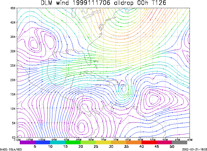
Figure 1. NCEP 850 - 200 hPa mean wind analysis for 17 November 1999 0600 UTC (Hurricane Lenny).
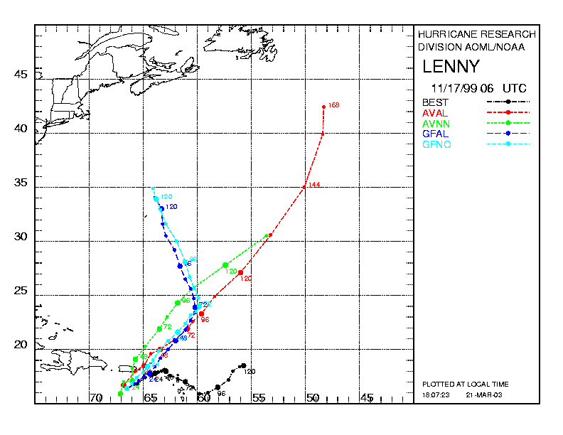
Figure 2. Track forecasts for the no dropwindsonde (NO or NN) and the all dropwindsonde (AL) runs for the AVN and GFDL models initialized on 17 November 1999 0600 UTC. The best track is shown in black.
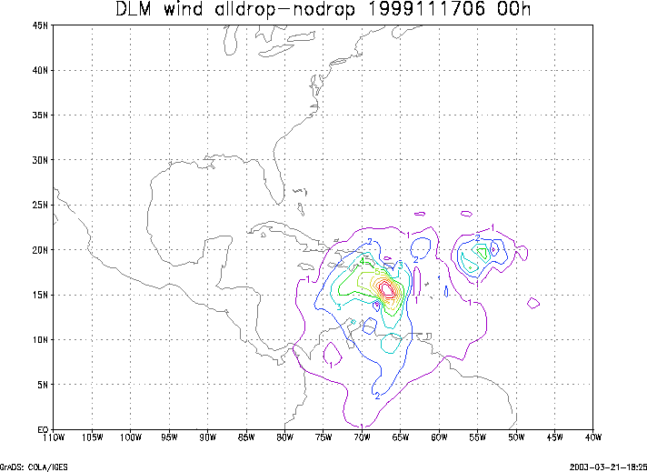
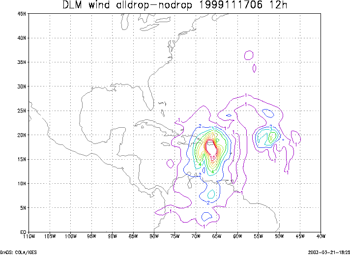
Figure 3. Initial condition differences in the 850 - 200 hPa mean wind between the no and all dropwindsonde cases for 17 November 1999 0600 UTC.