Effects of Synoptic Surveillance on model forecasts for
17 November 1999 0000 UTC
LENNY.
QuickTime movie of DLM wind model
forecasts
QuickTime movie of DLM wind data
increments
| TRACK (km) | ||||||||||||||||||||||||||||||||||||||||||||||||||||||||||||||||||||||||||||||||||||||||||||||||||||||||||||||||||||||||||||||||||||||||||||||||||||||||||||||||||||||||||||||||||||||||||||||||||||||||||||||||||||||||||||||||||||||||||||
| MODEL | 12 h | 24 h | 36 h | 48 h | 60 h | 72 h | 84 h | 96 h | 108 h | 120 h
|
| AVNN | 107. | 160. | 148. | 176. | 212. | 330. | 510. | 655. | 684. | 837.
| AVAL | 92. | 95. | 122. | 126. | 204. | 395. | 574. | 778. | 804. | 876.
| %IMP | 14% | 41% | 18% | 28% | 4% | -20% | -13% | -19% | -18% | -5%
|
| GFNO | 58. | 48. | 67. | 266. | 500. | 684. | 925. | 1248. | 1523. | 1814.
| GFAL | 54. | 109. | 31. | 217. | 456. | 623. | 849. | 1169. | 1440. | 1749.
| %IMP | 7% | -117% | 54% | 18% | 9% | 9% | 8% | 6% | 5% | 4%
| INTENSITY (kt)
| MODEL | 12 h | 24 h | 36 h | 48 h | 60 h | 72 h | 84 h | 96 h | 108 h | 120 h
|
| AVNN | -80. | -98. | -84. | -56. | -39. | -22. | -10. | -4. | -1. | 8.
| AVAL | -81. | -97. | -85. | -55. | -36. | -20. | -7. | 4. | 11. | 13.
| %IMP | -1% | 1% | -1% | 2% | 8% | 9% | 30% | 0% | -1000% | -63%
|
| GFNO | -5. | -21. | -7. | 16. | 32. | 41. | 47. | 63. | 69. | 61.
| GFAL | -4. | -18. | -13. | 17. | 34. | 39. | 43. | 64. | 71. | 62.
| %IMP | 20% | 14% | -86% | -6% | -6% | 5% | 9% | -2% | -3% | -2%
|
| SHNO | -13. | -30. | -27. | 0. | 8. | 7. | 6. | 9. | 13. | 14.
| SHAL | -12. | -31. | -28. | -1. | 7. | 5. | 4. | 9. | 13. | 14.
| %IMP | 8% | -3% | -4% | und% | 13% | 43% | 33% | 0% | 0% | 0%
|
| DSNO | -13. | -30. | -27. | 0. | 8. | 7. | 6. | 9. | 13. | 14.
| DSAL | -12. | -31. | -28. | -1. | 7. | 5. | 4. | 9. | 13. | 14.
| %IMP | 8% | -3% | -4% | und% | 13% | 43% | 33% | 0% | 0% | 0%
| | ||||||||||
| 17/1800 UTC 17.4N 64.8W St. Croix, USVI 18 h into the forecast | ||||||||||||||||||||||||||||||||||||||||||||||||||||||||||||||||||||||||||||||||||||||||||||||||||||||||||||||||||||||||||||||||||||||||||||||||||||||||||||||||||||||||||||||||||||||||||||||||||||||||||||||||||||||||||||||||||||||||||||||
| MODEL | LAT | LON | TIME | ERROR | LOCATION
|
| AVNN | 17.92 | 65.06 | 35.0 | 64.0 | Near Frederiksted, St. Croix, USVI
| AVAL | 17.60 | 65.70 | 15.5 | 97.9 | Near Guayama, PR
| %IMP | 85% | -53%
|
| GFNO | 17.59 | 64.39 | 26.5 | 48.3 | Near Christiansted, St. Croix, USVI
| GFAL | 17.51 | 64.22 | 31.5 | 62.7 | Near Christiansted, St. Croix, USVI
| %IMP | -59% | -30%
|
|
18/1800 UTC 18.0N 63.3W St. Martin 42 h into the forecast
| MODEL | LAT | LON | TIME | ERROR | LOCATION
|
| AVNN | 18.33 | 64.80 | 39.5 | 162.5 | Cruz Bay, St. John, USVI
| AVAL | 17.95 | 65.06 | 23.0 | 186.1 | Near Frederiksted, St. Croix, USVI
| %IMP | -660% | -15%
|
| GFNO | 18.50 | 63.60 | 36.0 | 63.9 | Sombrero Island, British West Indies
| GFAL | 18.46 | 63.53 | 38.5 | 56.6 | Sombrero Island, British West Indies
| %IMP | 42% | 11%
|
|
19/0000 UTC 18.1N 63.1W Anguilla 48 h into the forecast
| MODEL | LAT | LON | TIME | ERROR | LOCATION
|
|
| AVNN | 18.77 | 64.56 | 44.0 | 170.9 | Anegada, British Virgin Islands
| AVAL | 18.35 | 64.71 | 30.0 | 172.2 | Virgin Islands National Park, St. John, USVI
| %IMP | -350% | -1%
|
| GFNO | 18.50 | 63.60 | 36.0 | 69.0 | Sombrero Island, British West Indies
| GFAL | 18.46 | 63.53 | 38.5 | 60.5 | Sombrero Island, British West Indies
| %IMP | 21% | 12%
|
|
19/0600 UTC 18.0N 62.9W St. Barthelemy 54 h into the forecast
| MODEL | LAT | LON | TIME | ERROR | LOCATION
|
| AVNN | 18.77 | 64.56 | 44.0 | 194.8 | Anegada, British Virgin Islands
| AVAL | 18.44 | 64.64 | 31.5 | 190.0 | Road Town, Tortola, British Virgin Islands
| %IMP | 35% | 2%
|
| GFNO | 18.50 | 63.60 | 36.0 | 92.4 | Sombrero Island, British West Indies
| GFAL | 18.46 | 63.53 | 38.5 | 83.9 | Sombrero Island, British West Indies
| %IMP | 4% | 9%
|
|
20/0000 UTC 17.3N 61.8W Antigua 72 h into the forecast
| MODEL | LAT | LON | TIME | ERROR | LOCATION
|
| AVNN | 18.77 | 64.56 | 44.0 | 334.2 | Anegada, British Virgin Islands
| AVAL | 18.73 | 64.37 | 36.5 | 314.6 | Anegada, British Virgin Islands
| %IMP | -27% | 6%
|
| GFNO | 18.50 | 63.60 | 36.0 | 232.4 | Near Virgin Gorda, British Virgin Islands
| GFAL | 18.46 | 63.53 | 38.5 | 223.8 | Anegada, British Virgin Islands
| %IMP | 7% | 4%
| | ||||||||||||||||||||||||||||||||||||||||
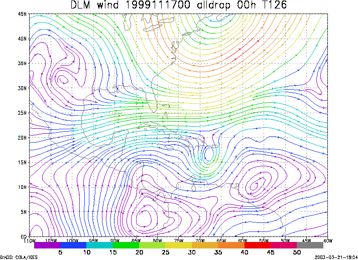
Figure 1. NCEP 850 - 200 hPa mean wind analysis for 17 November 1999 0000 UTC (Hurricane Lenny).
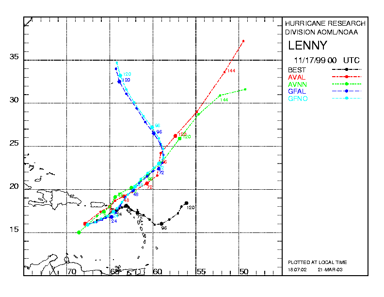
Figure 2. Track forecasts for the no dropwindsonde (NO or NN) and the all dropwindsonde (AL) runs for the AVN and GFDL models initialized on 17 November 1999 0000 UTC. The best track is shown in black.
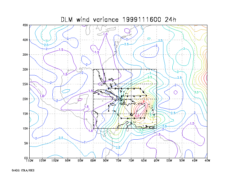
Figure 3. Ensemble perturbation variance at the nominal sampling time 17 November 1999 0000 UTC from the previous day NCEP ensemble forecast. The green circles represent the dropwindsonde locations.
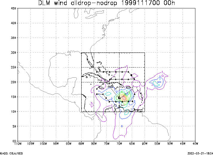
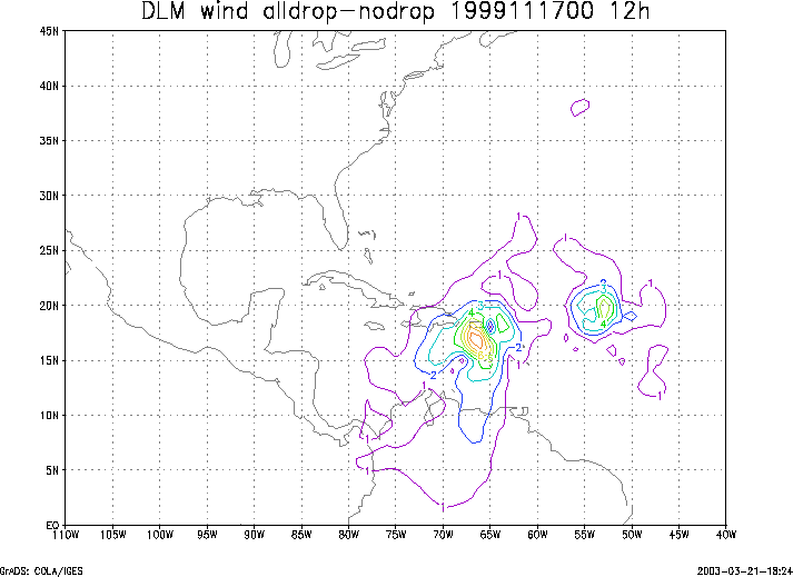
Figure 4. Initial condition differences in the 850 - 200 hPa mean wind between the no and all dropwindsonde cases for 17 November 1999 0000 UTC. The green circles represent the dropwindsonde locations.