Effects of Synoptic Surveillance on model forecasts for
04 October 2000 1800 UTC
KEITH.
QuickTime movie of DLM wind model forecasts
QuickTime movie of DLM wind data increments
| TRACK (km) | |||||||||||||||||||||||||||||||||||||||||||||||||||||||||||||||||||||||||||||||||||||||||||||||||||||||||||||||||||||||||||
| MODEL | 12 h | 24 h | 36 h | 48 h | 60 h | 72 h | 84 h | 96 h | 108 h | 120 h
|
| AVNN | 54. | 75. | 143.
| AVAL | 56. | 51. | 79.
| %IMP | -4% | 32% | 45%
|
| GFNO | 89. | 162. | 256.
| GFAL | 96. | 204. | 385.
| %IMP | -8% | -26% | -50%
|
| VBNO | 80. | 54. | 156.
| VBAL | 70. | 63. | 161.
| %IMP | 13% | -17% | -3%
| INTENSITY (kt)
| MODEL | 12 h | 24 h | 36 h | 48 h | 60 h | 72 h | 84 h | 96 h | 108 h | 120 h
|
| AVNN | -43. | -55. | -10.
| AVAL | -36. | -52. | -9.
| %IMP | 16% | 5% | 10%
|
| GFNO | -19. | -44. | -8.
| GFAL | -26. | -52. | -6.
| %IMP | -37% | -18% | 25%
|
| SHNO | -16. | -23. | 33.
| SHAL | -16. | -22. | 35.
| %IMP | 0% | 4% | -6%
|
| DSNO | -16. | -23. | 21.
| DSAL | -16. | -22. | 22.
| %IMP | 0% | 4% | -5%
| | ||||||||||
| 05/1800 UTC 22.6N 97.9W 20 nm north of Tampico, Mexico 24 h into the forecast | |||||||||||||||||||||||||||||||||||||||||||||||||||||||||||
| MODEL | LAT | LON | TIME | ERROR | LOCATION
|
| AVNN | 23.34 | 97.70 | 29.5 | 84.7 | Near Los Lavaderos, Tamaulipas, MX
| AVAL | 22.90 | 97.75 | 26.5 | 36.7 | Barra del Tordo, Tamaulipas, MX
| %IMP | 55% | 57%
|
| GFNO | 21.55 | 97.31 | 26.5 | 131.5 | Cabo Rojo, Veracruz, MX
| GFAL | 21.30 | 97.10 | 36.0 | 166.3 | Tamiahua, Veracruz, MX
| %IMP | -380% | -26%
|
| VBNO | 23.13 | 97.76 | 25.0 | 60.6 | Barra del Tordo, Tamaulipas, MX
| VBAL | 23.24 | 97.76 | 25.0 | 72.5 | Barra del Tordo, Tamaulipas, MX
| %IMP | 0% | -20%
| | ||||||
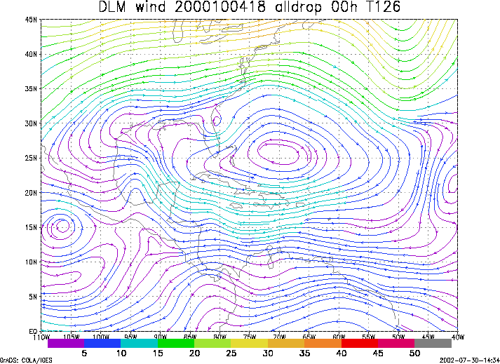
Figure 1. NCEP 850 - 200 hPa mean wind analysis for 04 October 2000 1800 UTC (Tropical Storm Keith).
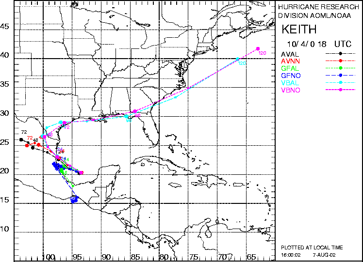
Figure 2. Track forecasts for the no dropwindsonde (NO or NN) and the all dropwindsonde (AL) runs for the AVN, GFDL, and VBAR models initialized on 04 October 2000 1800 UTC. The best track is shown in black.
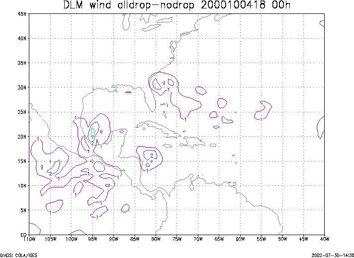
Figure 3. Initial condition differences in the 850 - 200 hPa mean wind between the no and all dropwindsonde cases for 04 October 2000 1800 UTC.
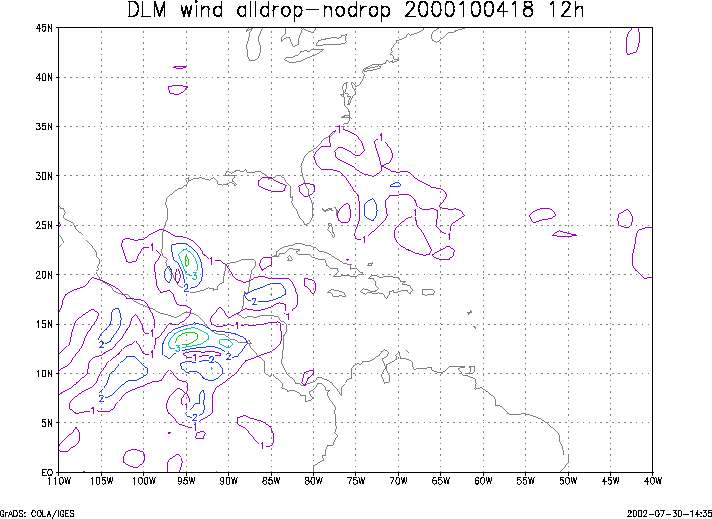
Figure 4. 12-h forecast differences in the 850 - 200 hPa mean wind between the no and all dropwindsonde cases for 04 October 2000 1800 UTC.