Effects of Synoptic Surveillance on model forecasts for
02 October 2000 1800 UTC
KEITH.
QuickTime movie of DLM wind model forecasts
QuickTime movie of DLM wind data increments
| TRACK (km) | |||||||||||||||||||||||||||||||||||||||||||||||||||||||||||||||||||||||||||||||||||||||||||||||||||||||||||||||||||||||||||||||||||||||||||||||||||||||||||||||||||||||||||||||||||||||||||||||||||||||||||||||||||
| MODEL | 12 h | 24 h | 36 h | 48 h | 60 h | 72 h | 84 h | 96 h | 108 h | 120 h
|
| AVNN | 84. | 199. | 358. | 561. | 794. | 1057.
| AVAL | 42. | 62. | 168. | 244. | 396. | 564.
| %IMP | 50% | 69% | 53% | 57% | 50% | 47%
|
| GFNO | 70. | 100. | 172. | 250. | 321. | 332. | 535. |
| GFAL | 84. | 138. | 212. | 276. | 393. | 538. | 868. |
| %IMP | -20% | -38% | -23% | -10% | -22% | -62% | -62%
|
| VBNO | 11. | 33. | 88. | 152. | 285. | 403. | 701. |
| VBAL | 11. | 35. | 67. | 143. | 261. | 356. | 590. |
| %IMP | 0% | -6% | 24% | 6% | 8% | 12% | 16%
| INTENSITY (kt)
| MODEL | 12 h | 24 h | 36 h | 48 h | 60 h | 72 h | 84 h | 96 h | 108 h | 120 h
|
| AVNN | -24. | -8. | -5. | -18. | -45. | -55.
| AVAL | -20. | -5. | -5. | -19. | -40. | -53.
| %IMP | 17% | 38% | 0% | -6% | 11% | 4%
|
| GFNO | -6. | 9. | 2. | 1. | -15. | -6. | 64. |
| GFAL | 1. | 9. | 4. | -7. | -24. | -27. | 50. |
| %IMP | 83% | 0% | -100% | -600% | -60% | -350% | 22%
|
| SHNO | 5. | 17. | 16. | 8. | -10. | -18. | 38. |
| SHAL | 5. | 16. | 17. | 11. | -8. | -16. | 40. |
| %IMP | 0% | 6% | -6% | -38% | 20% | 11% | -5%
|
| DSNO | -1. | 2. | -2. | -8. | -27. | -34. | 22. |
| DSAL | -1. | 2. | -2. | -7. | -25. | -33. | 22. |
| %IMP | 0% | 0% | 0% | 13% | 7% | 3% | 0%
| | ||||||||||
| 02/2300 UTC 17.9N 88.0W near Ambergris Cay, Belize 5 h into the forecast | ||||||||||||||||||||||||||||||||||||||||||||||||||||||||||||||||||||||||||||||||||||||||||||||||||||||||||||||||||||||||||||||||||||||||||||||||||||||||||||||||||||||||||||||||||||||||||||||||||||||||||||||
| MODEL | LAT | LON | TIME | ERROR | LOCATION
|
| AVNN | 18.74 | 87.69 | 18.0 | 98.9 | Majahual, Quintana Roo, Mexico
| AVAL | 17.96 | 87.94 | 11.0 | 9.2 | San Pedro, Ambergris Cay, Corozal, Belize
| %IMP | 54% | 91%
|
| GFNO | 17.48 | 88.26 | 3.5 | 54.2 | Near Gales Point, Belize, Belize
| GFAL | 17.48 | 88.01 | 3.0 | 46.7 | Turneffe Islands, Belize, Belize
| %IMP | -33% | 14%
|
| VBNO | 17.86 | 88.04 | 5.5 | 9.6 | San Pedro, Ambergris Cay, Corozal, Belize
| VBAL | 17.85 | 88.06 | 6.0 | 9.5 | San Pedro, Ambergris Cay, Corozal, Belize
| %IMP | -100% | 1%
|
|
| 03/0300 UTC 17.9N 88.2W 25 nm north of Belize City, Belize 9 h into the forecast
| MODEL | LAT | LON | TIME | ERROR | LOCATION
|
| AVNN | 19.20 | 87.82 | 21.0 | 149.9 | Bahia del Espiritu Santo, Quintana Roo, Mexico
| AVAL | 18.27 | 88.36 | 17.0 | 44.4 | Corozal, Corozal, Belize
| %IMP | 33% | 70%
|
| GFNO | 17.48 | 88.26 | 3.5 | 47.1 | Near Gales Point, Belize, Belize
| GFAL | 17.53 | 88.12 | 17.5 | 42.0 | Belize City, Belize, Belize
| %IMP | -55% | 11%
|
| VBNO | 18.15 | 88.47 | 13.5 | 39.8 | Near Corozal, Corozal, Belize
| VBAL | 18.15 | 88.47 | 13.5 | 39.8 | Near Corozal, Corozal, Belize
| %IMP | 0% | 0%
|
|
| 05/1800 UTC 22.6N 97.9W 20 nm north of Tampico, Mexico 72 h into the forecast
| MODEL | LAT | LON | TIME | ERROR | LOCATION
|
|
| AVNN | 29.15 | 90.86 | 70.5 | 1012.3 | Caillou Bay, LA
| AVAL | 29.80 | 93.60 | 87.0 |
907.5 | Near Port Arthur, TX
| %IMP | -900% | 10%
|
| GFNO | 28.16 | 96.44 | 97.5 | 634.9 | Near Port Lavaca, TX
| GFAL | 29.79 | 93.28 | 88.0 | 922.1 | Cameron, LA
| %IMP | 37% | -45%
|
| VBNO | 26.21 | 97.13 | 72.5 | 408.6 | Near Brownsville, TX
| VBAL | 26.81 | 97.34 | 72.5 | 471.1 | South Padre Island, TX
| %IMP | 0% | -15%
| | ||||||||||||||||||||||||||||||||||||||
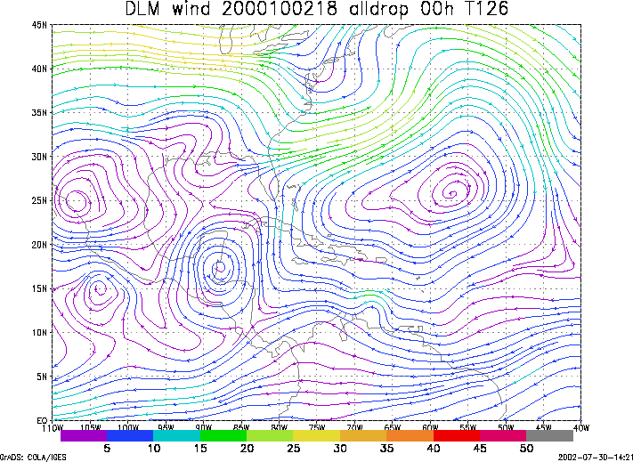
Figure 1. NCEP 850 - 200 hPa mean wind analysis for 02 October 2000 1800 UTC (Hurricane Keith).
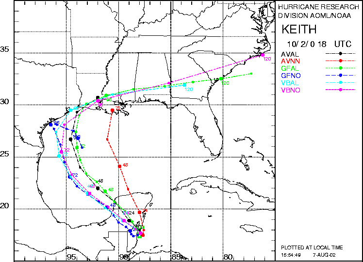
Figure 2. Track forecasts for the no dropwindsonde (NO or NN) and the all dropwindsonde (AL) runs for the AVN, GFDL, and VBAR models initialized on 02 October 2000 1800 UTC. The best track is shown in black.
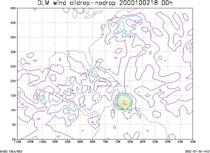
Figure 3. Initial condition differences in the 850 - 200 hPa mean wind between the no and all dropwindsonde cases for 02 October 2000 1800 UTC.
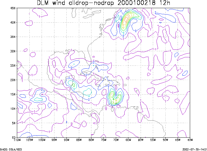
Figure 4. 12-h forecast differences in the 850 - 200 hPa mean wind between the no and all dropwindsonde cases for 02 October 2000 1800 UTC.