Effects of Synoptic Surveillance on model forecasts for
27 August 2005 0600 UTC
Katrina.
Quicktime movie of AVN DLM wind model
forecast
Quicktime movie of DLM wind data
increment
| TRACK (km) | ||||||||||||||||||||||||||||||||||||||||||||||||||||||||||||||||||||||||||||||||||||||||||||||||||||||||||||||||||||||||||||||||||||||||||||||||||||||||||||||||||||||||
| MODEL | 12 h | 24 h | 36 h | 48 h | 60 h | 72 h | 84 h | 96 h | 108 h | 120 h
|
| AVNN | 56 | 83 | 61 | 97 | 176 | 255 | 226 | 301 | |
| AVNO | 84 | 45 | 113 | 116 | 95 | 83 | 145 | 177 | |
| %IMP | -50% | 46% | -85% | -20% | 46% | 67% | 36% | 41% | |
|
| GFNO | 63 | 69 | 60 | 59 | 155 | 287 | 346 | 624 | |
| GFDL | 49 | 33 | 107 | 110 | 57 | 96 | 45 | 259 | |
| %IMP | 22% | 52% | -78% | -86% | 63% | 67% | 87% | 58% | |
| INTENSITY (kt)
| MODEL | 12 h | 24 h | 36 h | 48 h | 60 h | 72 h | 84 h | 96 h | 108 h | 120 h
|
| AVNN | -49 | -69 | -92 | -55 | -5 | 0 | -8 | -10 | |
| AVNO | -24 | -43 | -67 | -32 | -14 | -10 | -12 | -3 | |
| %IMP | 51% | 38% | 27% | 42% | -180% | und% | -50% | 70% | |
|
| GFNO | 1 | -6 | -23 | -9 | 28 | 19 | -2 | -6 | |
| GFDL | 3 | -10 | -35 | -5 | 13 | -9 | -4 | 3 | |
| %IMP | -200% | -67% | -52% | 44% | 54% | 53% | -100% | 50% | |
| | ||||||||||
| 29/1110 UTC 29.3N 89.6W Near Buras, LA 53.0 h into the forecast | ||||||||||||||||||||||||||||||||||||||||||||||||||||||||||||||||||||||||||||||||||||||||||
| MODEL | LAT | LON | TIME | ERROR | LOCATION
|
| AVNN | 29.13 | 90.23 | 57.5 | 63.9 | Grand Isle, LA
| AVNO | 30.40 | 88.65 | 57.0 | 152.7 | Pascagoula, MS
| %IMP | 11% | -139%
|
| GFNO | 29.28 | 90.49 | 56.0 | 86.3 | Cocodrie, LA
| GFDL | 30.37 | 89.03 | 56.0 | 131.0 | Gulfport, MS
| %IMP | 0% | -52%
|
|
29/1445 UTC 30.2N 89.6W Near LA/MS border 56.75 h into the forecast
| MODEL | LAT | LON | TIME | ERROR | LOCATION
|
| AVNN | 29.13 | 90.23 | 57.5 | 133.5 | Grand Isle, LA
| AVNO | 30.40 | 88.65 | 57.0 | 93.8 | Pascagoula, MS
| %IMP | -200% | 30%
|
| GFNO | 29.28 | 90.49 | 56.0 | 133.5 | Cocodrie, LA
| GFDL | 30.37 | 89.03 | 56.0 | 57.9 | Gulfport, MS
| %IMP | 0% | 57%
| | |||||||||||||
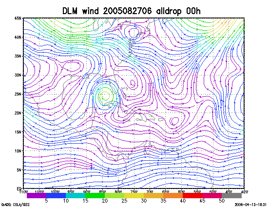
Figure 1. NCEP 850 - 200 hPa mean wind analysis for 27 August 2005 0600 UTC (Hurricane Katrina).
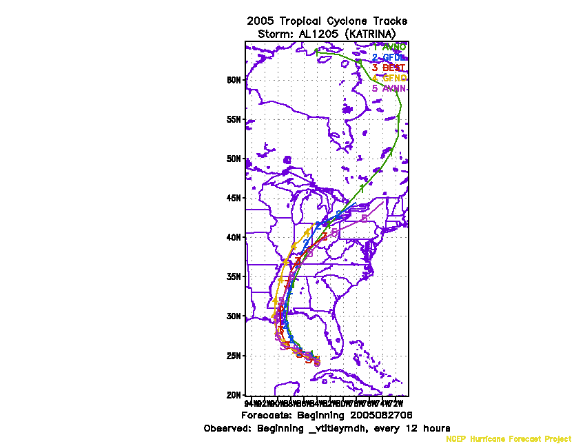
Figure 2. Track forecasts for the no dropwindsonde (NO or NN) and the all dropwindsonde (AL) runs for the AVN and GFDL models initialized on 27 August 2005 0600 UTC.
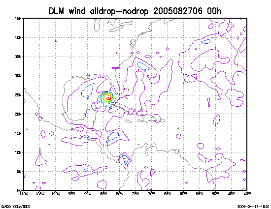
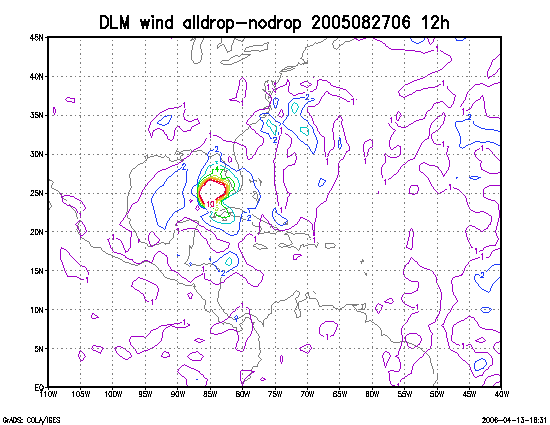
Figure 3. Initial condition differences in the 850 - 200 hPa mean wind between the no and all dropwindsonde cases for 27 August 2005 0600 UTC.