Effects of Synoptic Surveillance on model forecasts for
27 August 2005 0000 UTC
Katrina.
Quicktime movie of AVN DLM wind model
forecast
Quicktime movie of DLM wind data
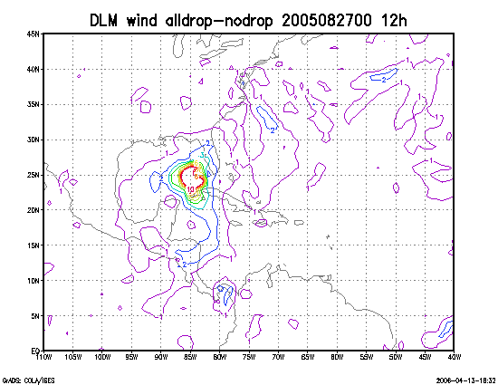
increment
| TRACK (km) | ||||||||||||||||||||||||||||||||||||||||||||||||||||||||||||||||||||||||||||||||||||||||||||||||||||||||||||||||||||||||||||||||||||||||||||||||||||||||||||||||||||||||
| MODEL | 12 h | 24 h | 36 h | 48 h | 60 h | 72 h | 84 h | 96 h | 108 h | 120 h
|
| AVNN | 87 | 113 | 211 | 233 | 301 | 451 | 528 | 572 | |
| AVNO | 49 | 35 | 24 | 44 | 83 | 131 | 118 | 110 | |
| %IMP | 45% | 69% | 89% | 81% | 72% | 71% | 78% | 81% | |
|
| GFNO | 38 | 90 | 105 | 99 | 156 | 290 | 395 | 568 | |
| GFDL | 30 | 35 | 39 | 35 | 89 | 176 | 250 | 347 | |
| %IMP | 21% | 61% | 63% | 69% | 43% | 39% | 37% | 39% | |
| INTENSITY (kt)
| MODEL | 12 h | 24 h | 36 h | 48 h | 60 h | 72 h | 84 h | 96 h | 108 h | 120 h
|
| AVNN | -51 | -43 | -94 | -81 | -32 | 27 | 1 | -7 | |
| AVNO | -38 | -28 | -63 | -51 | -14 | 1 | -4 | -12 | |
| %IMP | 25% | 35% | 33% | 37% | 56% | 96% | -300% | -71% | |
|
| GFNO | -3 | 8 | -23 | -16 | 13 | 45 | 2 | -4 | |
| GFDL | 10 | 7 | -23 | -19 | 17 | 38 | -5 | -3 | |
| %IMP | -233% | 12% | 0% | -19% | -31% | 16% | -150% | 25% | |
| | ||||||||||
| 29/1110 UTC 29.3N 89.6W Near Buras, LA 59.0 h into the forecast | ||||||||||||||||||||||||||||||||||||||||||||||||||||||||||||||||||||||||||||||||||||||||||
| MODEL | LAT | LON | TIME | ERROR | LOCATION
|
| AVNN | 29.53 | 92.31 | 71.5 | 263.5 | Pecan Island, LA
| AVNO | 29.42 | 89.90 | 63.0 | 32.0 | Grand Isle, LA
| %IMP | 68% | 88%
|
| GFNO | 29.33 | 91.12 | 63.5 | 147.3 | Near Morgan City, LA
| GFDL | 29.38 | 89.74 | 63.5 | 16.2 | Buras, LA
| %IMP | 0% | 89%
|
|
29/1445 UTC 30.2N 89.6W Near LA/MS border 62.75 h into the forecast
| MODEL | LAT | LON | TIME | ERROR | LOCATION
|
| AVNN | 29.53 | 92.31 | 71.5 | 271.5 | Pecan Island, LA
| AVNO | 29.42 | 89.90 | 63.0 | 91.4 | Grand Isle, LA
| %IMP | 97% | 66%
|
| GFNO | 29.33 | 91.12 | 63.5 | 182.7 | Near Morgan City, LA
| GFDL | 29.38 | 89.74 | 63.5 | 92.1 | Buras, LA
| %IMP | 0% | 50%
| | |||||||||||||
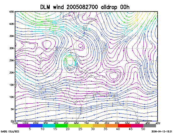
Figure 1. NCEP 850 - 200 hPa mean wind analysis for 27 August 2005 0000 UTC (Hurricane Katrina).
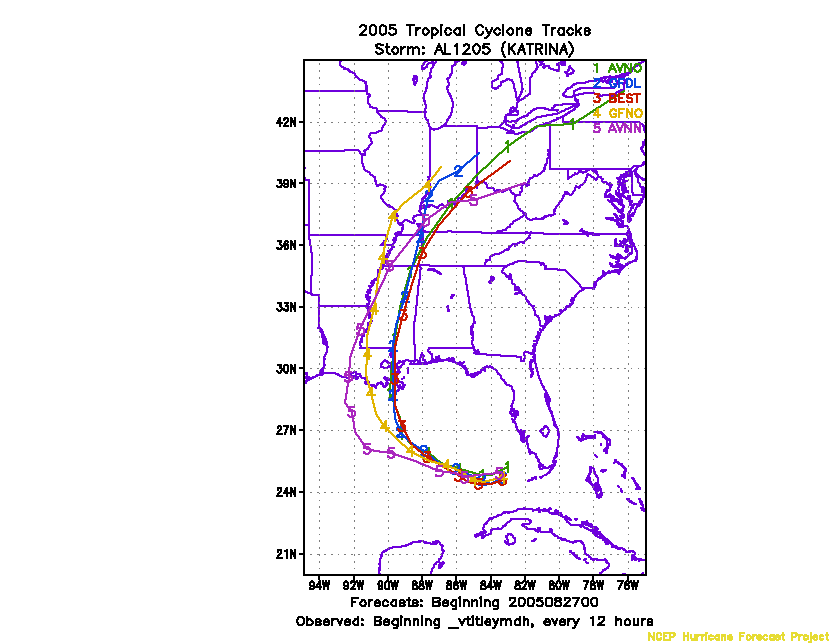
Figure 2. Track forecasts for the no dropwindsonde (NO or NN) and the all dropwindsonde (AL) runs for the AVN and GFDL models initialized on 27 August 2005 0000 UTC.
Figure 3. NCEP Global Ensemble Prediction System track forecasts for all cyclones in the Atlantic basin initialized from 25 August 2005 0600 UTC to 26 August 2005 0000 UTC, showing the tracks of Hurricane Katrina.
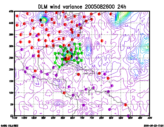
Figure 4. Ensemble perturbation variance at the nominal sampling time 27 August 2005 0000 UTC from the previous day NCEP ensemble forecast. The green circles represent the dropwindsonde locations.
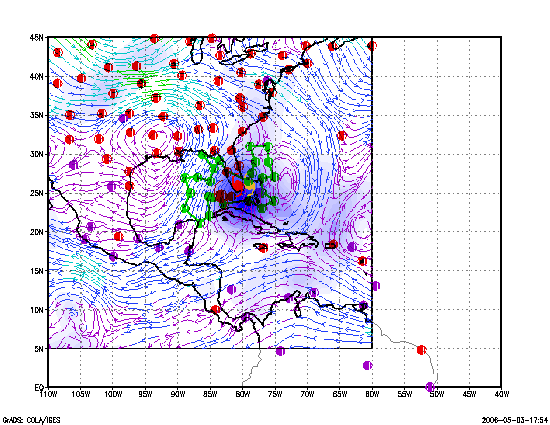
Figure 5. Variance explained within the verification region (large red circle) for observations taken at the sampling time 27 August 2005 0000 UTC from the Ensemble Transform Kalman Filter run from the previous day NCEP ensemble forecast. The green circles represent the dropwindsonde locations.
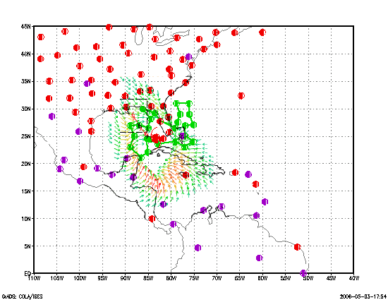
Figure 6. Adjoint-Derived Steering Sensitivity Vector for observations taken at the sampling time 27 August 2005 0000 UTC. The green circles represent the dropwindsonde locations.
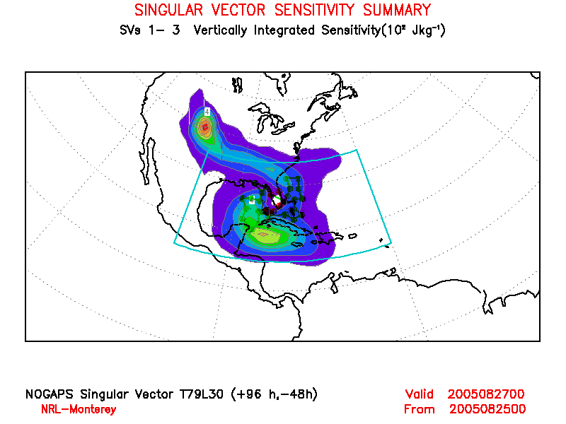
Figure 7. NOGAPS Singular Vector for observations taken at the sampling time 27 August 2005 0000 UTC. The green circles represent the dropwindsonde locations.
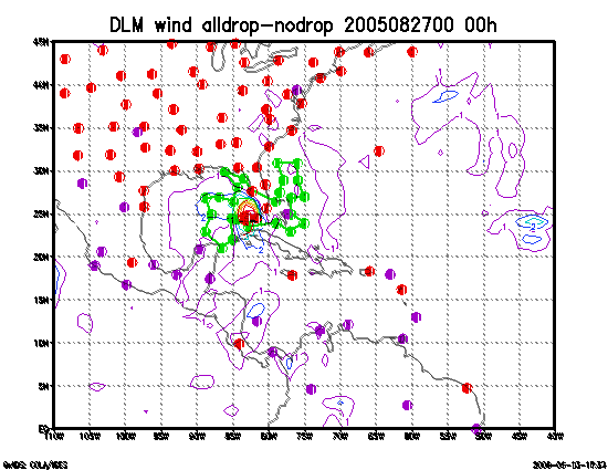
Figure 8. Initial condition differences in the 850 - 200 hPa mean wind between the no and all dropwindsonde cases for 27 August 2005 0000 UTC. The circles represent the dropwindsonde locations.