Effects of Synoptic Surveillance on model forecasts for
25 August 2005 1800 UTC
Katrina.
Quicktime movie of AVN DLM wind model
forecast
Quicktime movie of DLM wind data
increment
| TRACK (km) | ||||||||||||||||||||||||||||||||||||||||||||||||||||||||||||||||||||||||||||||||||||||||||||||||||||||||||||||||||||||||||||||||||||||||||||||||||||||||||||||||||||||||
| MODEL | 12 h | 24 h | 36 h | 48 h | 60 h | 72 h | 84 h | 96 h | 108 h | 120 h
|
| AVNN | 132 | 203 | 246 | 314 | 391 | 618 | 792 | 981 | 1063 | 1099
| AVNO | 104 | 143 | 179 | 201 | 260 | 498 | 617 | 758 | 967 | 1115
| %IMP | 21% | 30% | 27% | 36% | 34% | 19% | 22% | 23% | 9% | -1%
|
| GFNO | 40 | 135 | 248 | 330 | 346 | 428 | 470 | 497 | 541 | 605
| GFDL | 92 | 151 | 258 | 328 | 306 | 383 | 432 | 453 | 501 | 559
| %IMP | -130% | -12% | -4% | 1% | 12% | 11% | 8% | 9% | 7% | 8%
| INTENSITY (kt)
| MODEL | 12 h | 24 h | 36 h | 48 h | 60 h | 72 h | 84 h | 96 h | 108 h | 120 h
|
| AVNN | -33 | -53 | -65 | -69 | -95 | -130 | -94 | -47 | -7 | 3
| AVNO | -33 | -52 | -64 | -69 | -94 | -118 | -101 | -51 | -10 | 1
| %IMP | 0% | 2% | 2% | 0% | 1% | -9% | -7% | -9% | -43% | 67%
|
| GFNO | -6 | -1 | -15 | -15 | -26 | -41 | -22 | 15 | 7 | 16
| GFDL | 9 | -10 | -9 | 1 | -19 | -43 | -23 | 9 | 3 | 7
| %IMP | -50% | -900% | 40% | 93% | 27% | -5% | -5% | 40% | 57% | 56%
| | ||||||||||
| 25/2230 UTC 26.0N 80.1W at Broward/Miami-Dade County line, FL 4.5 h into the forecast | ||||||||||||||||||||||||||||||||||||||||||||||||||||||||||||||||||||||||||||||||||||||||||||||||||||||||||||||||||||||||||||||||||||||||||
| MODEL | LAT | LON | TIME | ERROR | LOCATION
|
| AVNN | 25.90 | 80.13 | 12.5 | 11.5 | Miami, FL
| AVNO | 26.18 | 80.08 | 6.5 | 20.1 | Fort Lauderdale, FL
| %IMP | 75% | -75%
|
| GFNO | 25.85 | 80.17 | 4.0 | 18.1 | Miami, FL
| GFDL | 26.01 | 80.13 | 7.0 | 3.2 | Hollywood, FL
| %IMP | -400% | 82%
|
|
29/1110 UTC 29.3N 89.6W Near Buras, LA 89.0 h into the forecast
| MODEL | LAT | LON | TIME | ERROR | LOCATION
|
| AVNN | 29.17 | 83.05 | 73.0 | 635.2 | Cedar Key, FL
| AVNO | 30.09 | 84.04 | 81.0 | 543.7 | St. Marks, FL
| %IMP | 50% | 14%
|
| GFNO | 29.89 | 84.61 | 94.0 | 486.5 | Carrabelle, FL
| GFDL | 29.75 | 85.12 | 91.5 | 426.4 | Apalachicola, FL
| %IMP | 50% | 12%
|
29/1445 UTC 30.2N 89.6W Near LA/MS border 92.75 h into the forecast
| MODEL | LAT | LON | TIME | ERROR | LOCATION
|
| AVNN | 29.17 | 83.05 | 73.0 | 642.5 | Cedar Key, FL
| AVNO | 30.09 | 84.04 | 81.0 | 534.3 | St. Marks, FL
| %IMP | 41% | 17%
|
| GFNO | 29.89 | 84.61 | 94.0 | 481.1 | Carrabelle, FL
| GFDL | 29.75 | 85.12 | 91.5 | 434.0 | Apalachicola, FL
| %IMP | 0% | 10%
| | ||||||||||||||||||||||
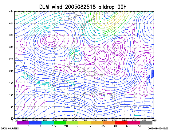
Figure 1. NCEP 850 - 200 hPa mean wind analysis for 25 August 2005 1800 UTC (Tropical Storm Katrina).
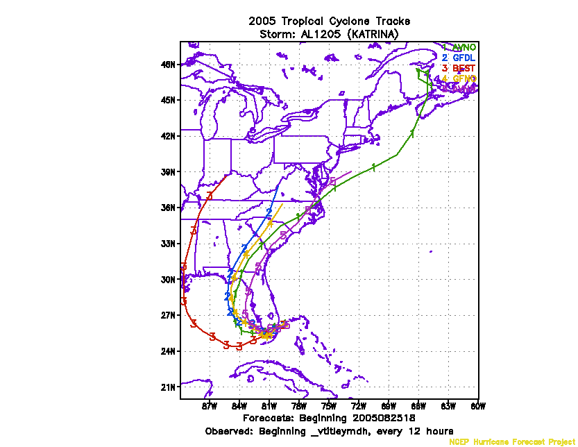
Figure 2. Track forecasts for the no dropwindsonde (NO or NN) and the all dropwindsonde (AL) runs for the AVN and GFDL models initialized on 25 August 2005 1800 UTC.
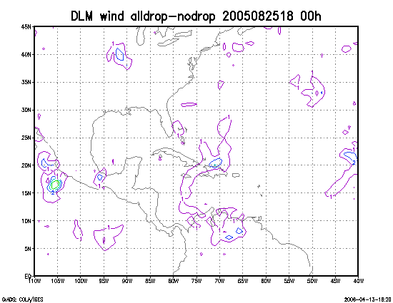
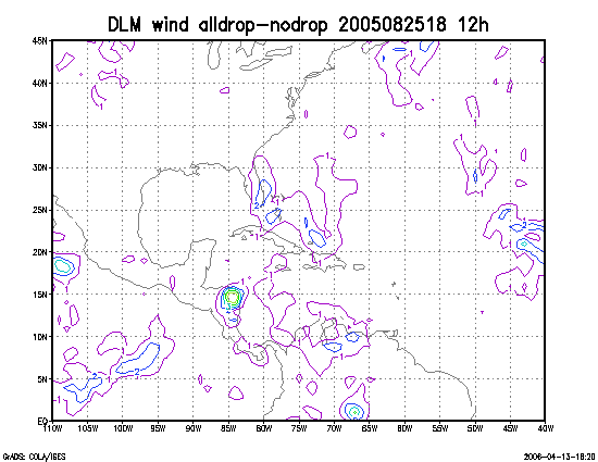
Figure 3. Initial condition differences in the 850 - 200 hPa mean wind between the no and all dropwindsonde cases for 25 August 2005 1800 UTC.