Effects of Synoptic Surveillance on model forecasts for
12 September 2004 0600 UTC
Ivan.
Quicktime movie of AVN DLM wind model
forecast
Quicktime movie of DLM wind data
increment
| TRACK (km) | ||||||||||||||||||||||||||||||||||||||||||||||||||||||||||||||||||||||||||||||||||||||||||||||||||||||||||||||||||||||||||||||||||||||||||||||||||||||||||||||||||||||||||
| MODEL | 12 h | 24 h | 36 h | 48 h | 60 h | 72 h | 84 h | 96 h | 108 h | 120 h
|
| AVNN | 15 | 53 | 73 | 131 | 182 | 198 | 266 | 320 | 389 | 403
| AVNO | 15 | 84 | 172 | 204 | 266 | 277 | 353 | 375 | 490 | 402
| %IMP | 0% | -59% | -136% | -56% | -46% | -40% | -33% | -17% | -26% | 0%
|
| GFNO | 25 | 10 | 56 | 56 | 135 | 163 | 163 | 102 | 87 | 111
| GFDL | 25 | 78 | 125 | 115 | 178 | 191 | 169 | 67 | 19 | 177
| %IMP | 0% | -680% | -125% | -103% | -32% | -17% | -4% | 34% | 78% | -59%
|
| INTENSITY (kt)
| MODEL | 12 h | 24 h | 36 h | 48 h | 60 h | 72 h | 84 h | 96 h | 108 h | 120 h
|
| AVNN | -64 | -65 | -60 | -62 | -41 | -46 | -44 | -24 | -4 | 17
| AVNO | -45 | -51 | -66 | -69 | -50 | -40 | -42 | -45 | -6 | 7
| %IMP | 30% | 22% | -10% | -11% | -22% | 13% | 5% | -88% | -50% | 59%
|
| GFNO | -17 | -13 | -5 | -19 | -3 | -9 | -18 | -15 | 3 | 11
| GFDL | -9 | -10 | -12 | -21 | -9 | -14 | -18 | -18 | 5 | 10
| %IMP | 47% | 23% | -140% | -11% | -200% | -56% | 0% | -20% | -67% | 9%
|
| | ||||||||||
| 12/1415 UTC 18.9N 81.5W 22 n mi SSW of Georgetown, Grand Cayman Island 8.25 h into the forecast | ||||||||||||||||||||||||||||||||||||||||||||||||||||||||||||||||||||||||||||||||||||||||||||||||||||||||||||||||||||||||||||||||||||||||||
| MODEL | LAT | LON | TIME | ERROR | LOCATION
|
| AVNN | 18.80 | 81.68 | 9.0 | 21.9 | Near Georgetown, Grand Cayman Island
| AVNO | 18.83 | 81.81 | 10.0 | 33.5 | Near Georgetown, Grand Cayman Island
| %IMP | -133% | -53%
|
| GFNO | 18.74 | 81.63 | 9.0 | 22.4 | Near Georgetown, Grand Cayman island
| GFDL | 19.03 | 81.62 | 9.0 | 19.2 | Near Georgetown, Grand Cayman Island
| %IMP | 0% | 14%
|
|
14/0100 UTC 21.7N 85.2W 15 n mi SW of Cabo San Antonio, Cuba 43.0 h into the forecast
| MODEL | LAT | LON | TIME | ERROR | LOCATION
|
| AVNN | 22.13 | 84.33 | 43.0 | 101.6 | La Fe, Pinar del Rio, Cuba
| AVNO | 22.20 | 83.80 | 36.0 | 154.6 | Galafre, Pinar del Rio, Cuba
| %IMP | und% | -52%
|
| GFNO | 21.82 | 85.04 | 39.5 | 21.2 | Near La Fe, Pinar del Rio, Cuba
| GFDL | 21.89 | 84.89 | 35.0 | 38.3 | Near La Fe, Pinar del Rio, Cuba
| %IMP | -78% | -81%
|
16/0650 UTC 30.2N 87.9W Near Pine Beach, AL 97.0 h into the forecast
| MODEL | LAT | LON | TIME | ERROR | LOCATION
|
| AVNN | 29.88 | 84.34 | 102.5 | 353.5 | St. Teresa, FL
| AVNO | 30.03 | 83.95 | 95.5 | 380.1 | St. Marks, FL
| %IMP | 73% | -7%
|
| GFNO | 30.42 | 86.96 | 93.5 | 93.4 | Pensacola, FL
| GFDL | 30.46 | 87.40 | 93.5 | 56.0 | Pensacola, FL
| %IMP | 0% | 40%
| | ||||||||||||||||||||||
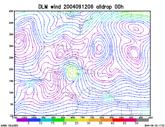
Figure 1. NCEP 850 - 200 hPa mean wind analysis for 12 September 2004 0600 UTC (Hurricane Ivan).
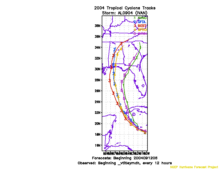
Figure 2. Track forecasts for the no dropwindsonde (NO or NN) and the all dropwindsonde (AL) runs for the AVN and GFDL models initialized on 12 September 2004 0600 UTC.
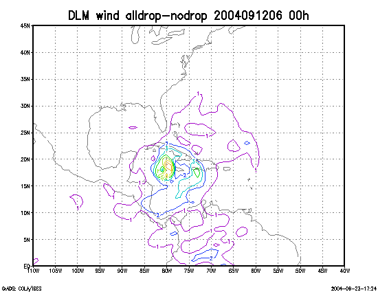
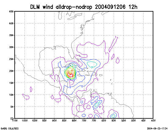
Figure 3. Initial condition differences in the 850 - 200 hPa mean wind between the no and all dropwindsonde cases for 12 September 2004 0600 UTC.