Effects of Synoptic Surveillance on model forecasts for
10 September 2004 0000 UTC
Ivan.
Quicktime movie of AVN DLM wind model
forecast
Quicktime movie of DLM wind data
increment
| TRACK (km) | ||||||||||||||||||||||||||||||||||||||||||||||||||||||||||||||||||||||||||||||||||||||||||||||||||||||||||||||||||||||||||||||||||||||||||||||||||||||||||||||||||||||||||
| MODEL | 12 h | 24 h | 36 h | 48 h | 60 h | 72 h | 84 h | 96 h | 108 h | 120 h
|
| AVNN | 24 | 15 | 54 | 109 | 100 | 190 | 346 | 423 | 582 | 748
| AVNO | 81 | 64 | 111 | 100 | 162 | 335 | 466 | 595 | 748 | 777
| %IMP | -238% | -307% | -106% | 8% | -62% | -76% | -35% | -41% | -29% | -4%
|
| GFNO | 54 | 81 | 54 | 92 | 164 | 255 | 352 | 446 | 544 | 613
| GFDL | 46 | 24 | 39 | 126 | 231 | 355 | 489 | 594 | 706 | 776
| %IMP | 15% | 70% | 28% | -37% | -41% | -39% | -40% | -33% | -30% | -27%
|
| INTENSITY (kt)
| MODEL | 12 h | 24 h | 36 h | 48 h | 60 h | 72 h | 84 h | 96 h | 108 h | 120 h
|
| AVNN | -82 | -86 | -79 | -88 | -71 | -76 | -83 | -88 | -74 | -66
| AVNO | -75 | -72 | -70 | -80 | -58 | -71 | -84 | -85 | -69 | -75
| %IMP | 9% | 16% | 11% | 9% | 18% | 7% | -1% | 3% | 7% | -14%
|
| GFNO | -8 | -9 | -5 | -26 | -15 | -23 | -33 | -40 | -26 | -36
| GFDL | -13 | -14 | -6 | -25 | -13 | -30 | -33 | -45 | -39 | -42
| %IMP | -63% | -56% | -20% | 4% | 13% | -30% | 0% | -13% | -50% | -17%
|
| | ||||||||||
| 11/0330 UTC 17.4N 77.2W 20 n mi S of Portland Point, Jamaica 27.5 h into the forecast | ||||||||||||||||||||||||||||||||||||||||||||||||||||||||||||||||||||||||||||||||||||||||||||||||||||||||||||||||||||||||||||||||||||||||||||||||||||||||||||||||||||||||||||||||||||||||||
| MODEL | LAT | LON | TIME | ERROR | LOCATION
|
| AVNN | 17.86 | 77.78 | 30.0 | 79.9 | Black River, Jamaica
| AVNO | 17.88 | 76.94 | 25.0 | 60.0 | Kingston, Jamaica
| %IMP | 0% | 25%
|
| GFNO | 17.35 | 78.03 | 29.5 | 88.2 | Near Brokenbank, Jamaica
| GFDL | 17.49 | 77.37 | 29.0 | 20.6 | Near Kingston, Jamaica
| %IMP | 25% | 77%
|
|
12/1415 UTC 18.9N 81.5W 22 n mi SSW of Georgetown, Grand Cayman Island 62.25 h into the forecast
| MODEL | LAT | LON | TIME | ERROR | LOCATION
|
| AVNN | 19.61 | 80.93 | 64.5 | 99.0 | Near Georgetown, Grand Cayman Island
| AVNO | 19.70 | 80.33 | 56.5 | 151.5 | Little Cayman Island
| %IMP | -229% | -53%
|
| GFNO | 19.46 | 80.95 | 54.0 | 84.9 | Near Georgetown, Grand Cayman Island
| GFDL | 20.41 | 80.28 | 57.0 | 210.8 | Offshore Cayman Brac
| %IMP | 36% | -148%
|
14/0100 UTC 21.7N 85.2W 15 n mi SW of Cabo San Antonio, Cuba 97.0 h into the forecast
| MODEL | LAT | LON | TIME | ERROR | LOCATION
|
| AVNN | 22.10 | 81.30 | 84.0 | 404.5 | Near Cienfuegos, Cienfuegos, Cuba
| AVNO | 22.09 | 81.03 | 72.5 | 432.0 | Near Cienfuegos, Cienfuegos, Cuba
| %IMP | -88% | -7%
|
| GFNO | 22.43 | 83.09 | 76.5 | 231.9 | Los Palacios, Pinar del Rio, Cuba
| GFDL | 22.58 | 81.63 | 72.5 | 380.2 | Guira de Macurijes, Matanzas, Cuba
| %IMP | -19% | -64%
|
|
16/0650 UTC 30.2N 87.9W Near Pine Beach, AL 151.0 h into the forecast
| MODEL | LAT | LON | TIME | ERROR | LOCATION
|
| AVNN | 25.72 | 81.28 | 107.0 | 818.4 | Chokoloskee, FL
| AVNO | 25.51 | 81.22 | 95.5 | 837.9 | Near Chokoloskee, FL
| %IMP | -18% | -2%
|
| GFNO | No landfall forecast
| GFDL | 26.88 | 82.09 | 100.0 | 676.5 | Port Charlotte, FL
| %IMP |
| | |||||||||||||||||||||||||||||||||||
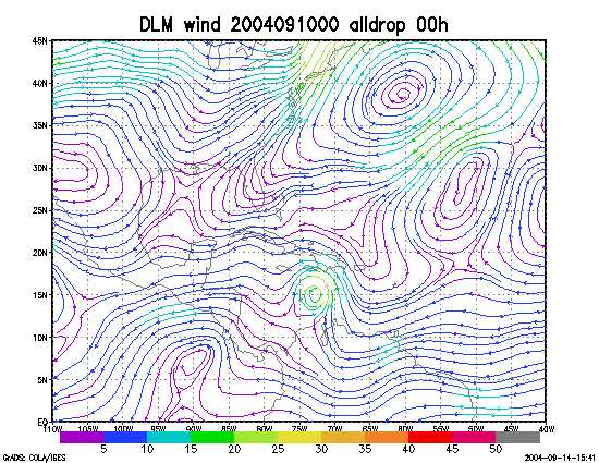
Figure 1. NCEP 850 - 200 hPa mean wind analysis for 10 September 2004 0000 UTC (Hurricane Ivan).
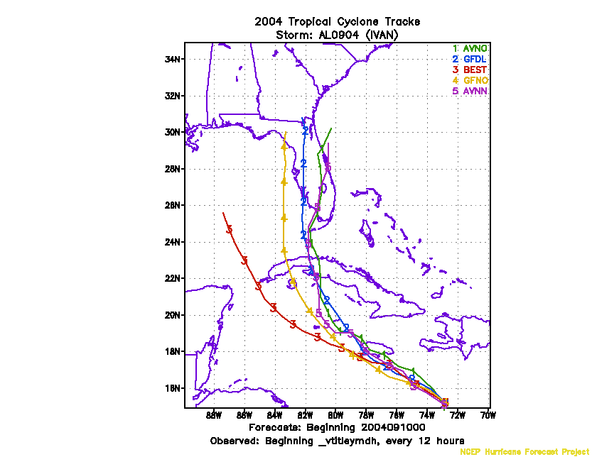
Figure 2. Track forecasts for the no dropwindsonde (NO or NN) and the all dropwindsonde (AL) runs for the AVN and GFDL models initialized on 10 September 2004 0000 UTC.
Figure 3. NCEP Global Ensemble Predction System track forecasts for all cyclones in the Atlantic basin initialized from 08 september 2004 0600 UTC to 09 September 2004 0000 UTC, showing the tracks of Hurricane Ivan.
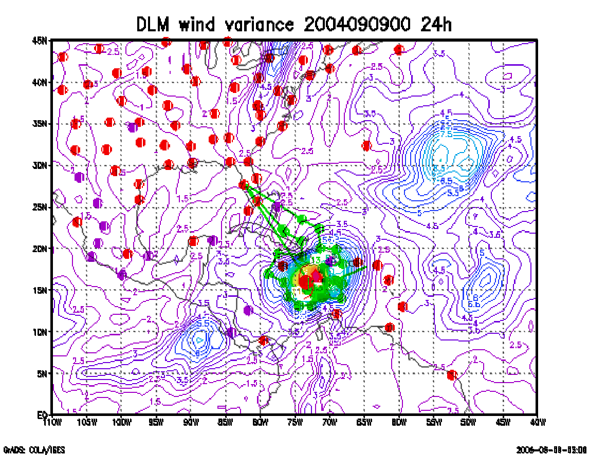
Figure 4. Ensemble perturbation variance at the nominal sampling time 10 September 2004 0000 UTC from the previous day NCEP ensemble forecast. The green circles represent the dropwindsonde locations.
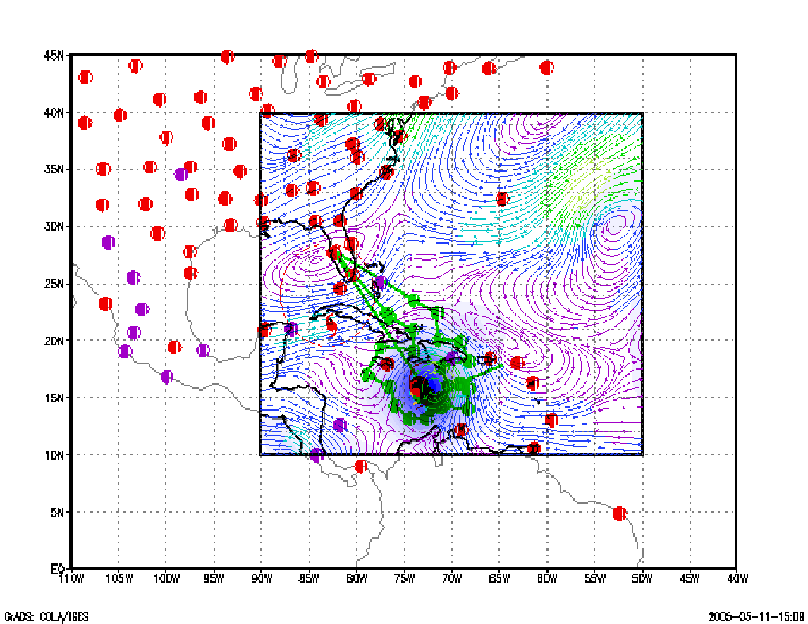
Figure 5. Variance explained within the verification region (large red circle) for observations taken at the sampling time 10 September 2004 0000 UTC from the Ensemble Transform Kalman Filter run from the previous day NCEP ensemble forecast. The green circles represent the dropwindsonde locations.
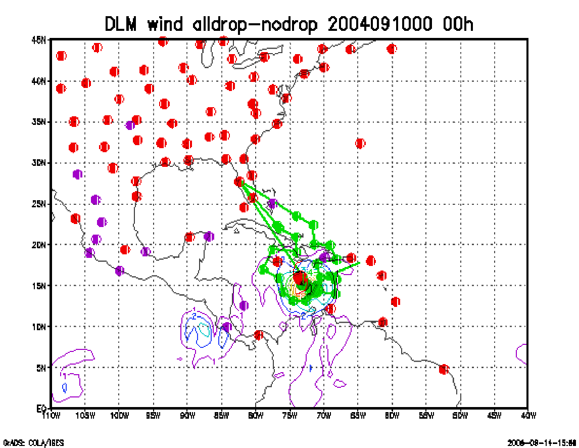
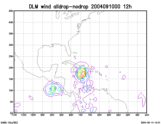
Figure 6. Initial condition differences in the 850 - 200 hPa mean wind between the no and all dropwindsonde cases for 10 September 2004 0000 UTC. The circles represent the dropwindsonde locations.