Effects of Synoptic Surveillance on model forecasts for
08 September 2004 1800 UTC
Ivan.
Quicktime movie of AVN DLM wind model
forecast
Quicktime movie of DLM wind data
increment
| TRACK (km) | ||||||||||||||||||||||||||||||||||||||||||||||||||||||||||||||||||||||||||||||||||||||||||||||||||||||||||||||||||||||||||||||||||||||||||||||||||||||||||||||||||||||||||
| MODEL | 12 h | 24 h | 36 h | 48 h | 60 h | 72 h | 84 h | 96 h | 108 h | 120 h
|
| AVNN | 54 | 100 | 112 | 149 | 239 | 335 | 484 | 618 | 704 | 815
| AVNO | 63 | 156 | 223 | 308 | 398 | 520 | 604 | 781 | 959 | 1153
| %IMP | -17% | -56% | -99% | -107% | -67% | -55% | -25% | -26% | -36% | -41%
|
| GFNO | 84 | 178 | 267 | 289 | 300 | 344 | 413 | 488 | 620 | 780
| GFDL | 123 | 193 | 290 | 315 | 306 | 346 | 401 | 484 | 604 | 703
| %IMP | -46% | -8% | -9% | -9% | -2% | -1% | 3% | 1% | 3% | 10%
|
| INTENSITY (kt)
| MODEL | 12 h | 24 h | 36 h | 48 h | 60 h | 72 h | 84 h | 96 h | 108 h | 120 h
|
| AVNN | -101 | -91 | -84 | -78 | -77 | -96 | -84 | -81 | -93 | -89
| AVNO | -88 | -72 | -72 | -73 | -85 | -93 | -87 | -85 | -87 | -84
| %IMP | 13% | 21% | 14% | 6% | -10% | 3% | -4% | -5% | 5% | 6%
|
| GFNO | -20 | -1 | 1 | -2 | -28 | -51 | -46 | -50 | -57 | -57
| GFDL | -22 | -12 | -9 | -15 | -37 | -60 | -56 | -47 | -55 | -55
| %IMP | -8% | -1100% | -800% | -650% | -32% | -18% | -22% | 6% | 4% | 4%
|
| | ||||||||||
| 11/0330 UTC 17.4N 77.2W 20 n mi S of Portland Point, Jamaica 57.5 h into the forecast | ||||||||||||||||||||||||||||||||||||||||||||||||||||||||||||||||||||||||||||||||||||||||||||||||||||||||||||||||||||||||||||||||||||||||||||||||||||||||||||||||||||||||||||||||||||||||||||
| MODEL | LAT | LON | TIME | ERROR | LOCATION
|
| AVNN | 18.51 | 75.76 | 65.5 | 194.9 | Near Boston Bay, Jamaica
| AVNO | 18.24 | 73.28 | 43.5 | 425.0 | Anguin, Haiti
| %IMP | -75% | -118%
|
| GFNO | 18.23 | 74.07 | 37.0 | 343.7 | Port-A-Piment, Haiti
| GFDL | 18.23 | 73.42 | 35.5 | 410.3 | Anguin, Haiti
| %IMP | -7% | -19%
|
|
12/1415 UTC 18.9N 81.5W 22 n mi SSW of Georgetown, Grand Cayman Island 92.25 h into the forecast
| MODEL | LAT | LON | TIME | ERROR | LOCATION
|
| AVNN | 20.00 | 76.10 | 84.0 | 578.8 | Santiago de Cuba, Santiago de Cuba, Cuba
| AVNO | 20.02 | 74.80 | 63.5 | 712.8 | Vateras, Guantanamo, Cuba
| %IMP | -248% | -23%
|
| GFNO | 19.89 | 77.15 | 56.5 | 468.9 | Near Bartolome Maso, Granma, Cuba
| GFDL | 19.95 | 76.56 | 56.5 | 530.6 | Near Guisa, Granma, Cuba
| %IMP | 0% | -13%
|
14/0100 UTC 21.7N 85.2W 15 n mi SW of Cabo San Antonio, Cuba 127.0 h into the forecast
| MODEL | LAT | LON | TIME | ERROR | LOCATION
|
| AVNN | 20.00 | 76.10 | 84.0 | 963.5 | Santiago de Cuba, Santiago de Cuba, Cuba
| AVNO | 20.02 | 74.80 | 63.5 | 1095.7 | Vateras, Guantanamo, Cuba
| %IMP | -48% | -14%
|
| GFNO | 21.64 | 79.52 | 78.5 | 586.7 | Banao, Sancti Spiritus, Cuba
| GFDL | 21.59 | 78.86 | 81.0 | 654.8 | Near Ciego de Avila, Ciego de Avila, Cuba
| %IMP | 5% | -12%
|
|
16/0650 UTC 30.2N 87.9W Near Pine Beach, AL 186.0 h into the forecast
| MODEL | LAT | LON | TIME | ERROR | LOCATION
|
| AVNN | No landfall forecast
| AVNO | No landfall forecast
| %IMP | |
|
| GFNO | 24.95 | 80.58 | 109.0 | 927.3 | Plantation Key, FL
| GFDL | 25.50 | 80.11 | 118.5 | 926.4 | South Miami Heights, FL
| %IMP | 12% | 0%
|
| | |||||||||||||||||||||||||||||||||||||||
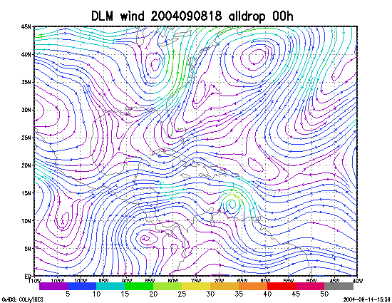
Figure 1. NCEP 850 - 200 hPa mean wind analysis for 08 September 2004 1800 UTC (Hurricane Ivan).
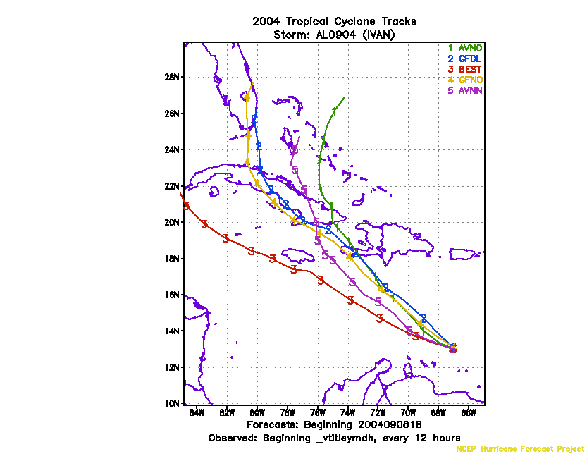
Figure 2. Track forecasts for the no dropwindsonde (NO or NN) and the all dropwindsonde (AL) runs for the AVN and GFDL models initialized on 08 September 2004 1800 UTC.
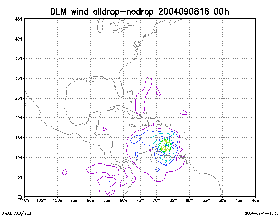
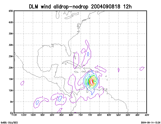
Figure 3. Initial condition differences in the 850 - 200 hPa mean wind between the no and all dropwindsonde cases for 08 September 2004 1800 UTC.