Effects of Synoptic Surveillance on model forecasts for
07 September 2004 1200 UTC
Ivan.
Quicktime movie of AVN DLM wind model
forecast
Quicktime movie of DLM wind data
increment
| TRACK (km) | ||||||||||||||||||||||||||||||||||||||||||||||||||||||||||||||||||||||||||||||||||||||||||||||||||||||||||||||||||||||||||||||||||||||||||||||||||||||||||||||||||||||||||
| MODEL | 12 h | 24 h | 36 h | 48 h | 60 h | 72 h | 84 h | 96 h | 108 h | 120 h
|
| AVNN | 116 | 102 | 67 | 31 | 48 | 82 | 113 | 31 | 84 | 156
| AVNO | 55 | 86 | 55 | 48 | 97 | 130 | 93 | 48 | 67 | 244
| %IMP | 53% | 16% | 18% | -55% | -102% | -56% | 18% | -55% | 20% | -156%
|
| GFNO | 93 | 69 | 46 | 56 | 184 | 188 | 242 | 295 | 381 | 423
| GFDL | 34 | 89 | 133 | 174 | 215 | 287 | 329 | 344 | 428 | 466
| %IMP | 63% | -29% | -189% | -211% | -17% | -55% | -36% | -17% | -12% | -10%
|
| INTENSITY (kt)
| MODEL | 12 h | 24 h | 36 h | 48 h | 60 h | 72 h | 84 h | 96 h | 108 h | 120 h
|
| AVNN | -80 | -86 | -89 | -102 | -90 | -82 | -91 | -79 | -96 | -87
| AVNO | -59 | -61 | -74 | -86 | -59 | -57 | -75 | -69 | -90 | -74
| %IMP | 26% | 29% | 17% | 16% | 34% | 30% | 18% | 13% | 6% | 15%
|
| GFNO | -14 | -7 | -7 | -11 | -9 | -5 | -24 | -19 | -36 | -28
| GFDL | -4 | 11 | -8 | -18 | -16 | -17 | -34 | -20 | -39 | -34
| %IMP | 71% | -57% | -14% | -64% | -78% | -240% | -42% | -5% | -8% | -21%
|
| | ||||||||||
| 07/2130 UTC 11.9N 61.8W 6 n mi SW of Prickly Point, Grenada 9.5 h into the forecast | |||||||||||||||||||||||||||||||||||||||||||||||||||||||||||||||||||||||||||||||||||||||||||||||||||||||||||||||||||||||||||||||||||||||||||||||||||||||||||||||||||||||||||||||||||||||||||||||||||||||||||||||||||||||||||||||||||||||||||
| MODEL | LAT | LON | TIME | ERROR | LOCATION
|
| AVNN | 10.99 | 61.92 | 7.0 | 101.9 | Offshore Port Of Spain, Trinidad, Trinidad and Tobago
| AVNO | 11.93 | 61.81 | 7.5 | 3.5 | St. George's, Grenada
| %IMP | 20% | 97%
|
| GFNO | 11.80 | 60.67 | 6.0 | 123.4 | Near Grenville, Grenada
| GFDL | 11.92 | 61.77 | 10.0 | 3.9 | St. George's, Grenada
| %IMP | 86% | 97%
|
|
11/0330 UTC 17.4N 77.2W 20 n mi S of Portland Point, Jamaica 87.5 h into the forecast
| MODEL | LAT | LON | TIME | ERROR | LOCATION
|
| AVNN | 17.28 | 78.35 | 94.0 | 122.7 | Offshore Black River, Jamaica
| AVNO | 16.94 | 77.52 | 86.5 | 61.4 | Offshore May Pen, Jamaica
| %IMP | 85% | 50%
|
| GFNO | 17.49 | 77.26 | 77.0 | 11.3 | Near May Pen, Jamaica
| GFDL | 17.82 | 77.36 | 74.0 | 49.6 | May Pen, Jamaica
| %IMP | -29% | -339%
|
|
12/1415 UTC 18.9N 81.5W 22 n mi SSW of Georgetown, Grand Cayman Island 122.25 h into the forecast
| MODEL | LAT | LON | TIME | ERROR | LOCATION
|
| AVNN | 19.74 | 80.75 | 115.5 | 122.0 | Near Georgetown, Grand Cayman Island
| AVNO | No landfall forecast
| %IMP | |
|
| GFNO | 18.55 | 81.64 | 99.0 | 41.6 | Offshore Georgetown, Grand Cayman Island
| GFDL | 18.30 | 81.50 | 96.0 | 66.7 | Offshore Georgetown, Grand Cayman Island
| %IMP | -13% | -60%
|
|
14/0100 UTC 21.7N 85.2W 15 n mi SW of Cabo San Antonio, Cuba 157.0 h into the forecast
| MODEL | LAT | LON | TIME | ERROR | LOCATION
|
| AVNN | No landfall forecast
| AVNO | No landfall forecast
| %IMP | |
|
| GFNO | No landfall forecast
| GFDL | No landfall forecast
| %IMP |
|
|
16/0650 UTC 30.2N 87.9W Near Pine Beach, AL 216.0 h into the forecast
| MODEL | LAT | LON | TIME | ERROR | LOCATION
|
| AVNN | No landfall forecast
| AVNO | No landfall forecast
| %IMP | |
|
| GFNO | No landfall forecast
| GFDL | No landfall forecast
| %IMP |
| | ||||||||||||||||||||||||||||||||||||||||||||||||||||||||||||||||||||||||||||
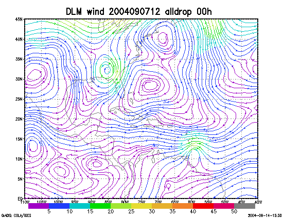
Figure 1. NCEP 850 - 200 hPa mean wind analysis for 07 September 2004 1200 UTC (Hurricane Ivan).
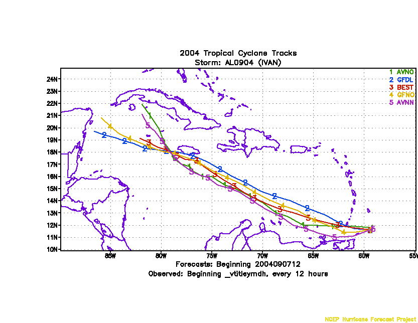
Figure 2. Track forecasts for the no dropwindsonde (NO or NN) and the all dropwindsonde (AL) runs for the AVN and GFDL models initialized on 07 September 2004 1200 UTC.
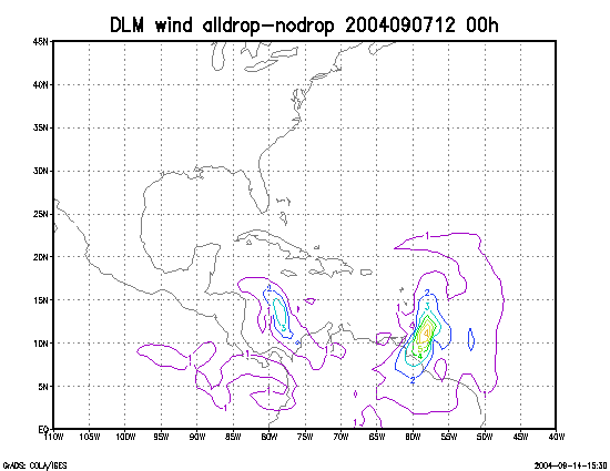
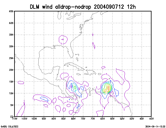
Figure 3. Initial condition differences in the 850 - 200 hPa mean wind between the no and all dropwindsonde cases for 07 September 2004 1200 UTC.