Effects of Synoptic Surveillance on model forecasts for
15 October 1999 0600 UTC
IRENE.
QuickTime movie of DLM wind model
forecasts
QuickTime movie of DLM wind data
increments
| TRACK (km) | ||||||||||||||||||||||||||||||||||||||||||||||||||||||||||||||||||||||||||||||||||||||||||||||||||||||||||||||||||||||||||||||||||||||||||||||||||||||||||||||||||||||||||||||||||||||||||||||||||
| MODEL | 12 h | 24 h | 36 h | 48 h | 60 h | 72 h | 84 h | 96 h | 108 h | 120 h
|
| AVNN | 285. | 386. | 376. | 316. | 143.
| AVAL | 129. | 196. | 138. | 153. | 211.
| %IMP | 55% | 49% | 63% | 52% | -48%
|
| GFNO | 123. | 298. | 370. | 357. | 284. | 274. | 411. | 807. | 601.
| GFAL | 101. | 228. | 248. | 169. | 191. | 318. | 557. | 807. | 625.
| %IMP | 18% | 23% | 33% | 53% | 33% | -16% | -36% | 0% | -4%
| INTENSITY (kt)
| MODEL | 12 h | 24 h | 36 h | 48 h | 60 h | 72 h | 84 h | 96 h | 108 h | 120 h
|
| AVNN | -36. | -37. | -40. | -44. | -43.
| AVAL | -34. | -33. | -35. | -39. | -36.
| %IMP | 6% | 11% | 13% | 11% | 16%
|
| GFNO | 11. | 6. | 10. | -19. | -27. | -47. | -10. | -17. | -27.
| GFAL | 12. | -7. | -29. | -8. | -11. | -26. | -7. | -14. | -20.
| %IMP | -9% | -17% | -190% | 58% | 59% | 45% | 30% | 18% | 26%
|
| SHNO | 1. | 1. | 1. | 1. | -5. | -34. | -18. | -17. | -18.
| SHAL | 1. | 1. | -1. | -1. | -7. | -35. | -19. | -18. | -18.
| %IMP | 0% | 0% | 0% | 0% | -47% | -3% | -6% | -6% | 0%
|
| DSNO | 1. | 1. | -27. | -35. | -42. | -68. | -53. | -53. | -53.
| DSAL | 1. | 1. | -27. | -35. | -42. | -68. | -53. | -53. | -53.
| %IMP | 0% | 0% | 0% | 0% | 0% | 0% | 0% | 0% | 0%
| | ||||||||||
| 15/1300 UTC 24.6N 81.6W Key West, FL 7 h into the forecast | ||||||||||||||||||||||||||||||||||||||||||||||||||||||||||||||||||||||||||||||||||||||||||
| MODEL | LAT | LON | TIME | ERROR | LOCATION
|
| AVNN | 25.02 | 83.09 | 26.0 | 157.3 | Near Dry Tortugas, FL
| AVAL | 24.74 | 82.49 | 12.5 | 91.2 | Near Dry Tortugas, FL
| %IMP | 71% | 42%
|
| GFNO | 24.47 | 82.23 | 5.0 | 65.3 | Dry Tortugas, FL
| GFAL | 24.49 | 82.20 | 6.0 | 61.9 | Dry Tortugas, FL
| %IMP | 50% | 5%
|
|
15/2000 UTC 25.3N 81.1W Cape Sable, FL 14 h into the forecast
| MODEL | LAT | LON | TIME | ERROR | LOCATION
|
| AVNN | 27.68 | 82.75 | 43.5 | 311.2 | St. Petersburg, FL
| AVAL | 26.29 | 81.84 | 25.0 | 132.6 | Naples Park, FL
| %IMP | 63% | 57%
|
| GFNO | 29.94 | 83.69 | 44.0 | 575.1 | Dekle Beach, FL
| GFAL | 26.53 | 82.41 | 25.0 | 189.2 | Captiva Island, FL
| %IMP | 63% | 67%
| | |||||||||||||
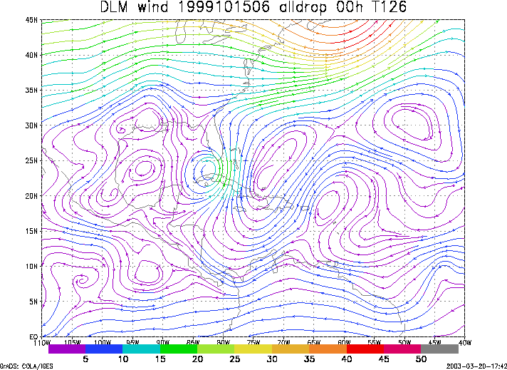
Figure 1. NCEP 850 - 200 hPa mean wind analysis for 15 October 1999 0600 UTC (Hurricane Irene).
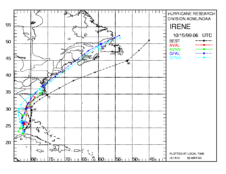
Figure 2. Track forecasts for the no dropwindsonde (NO or NN) and the all dropwindsonde (AL) runs for the AVN and GFDL models initialized on 15 October 1999 0600 UTC. The best track is shown in black.
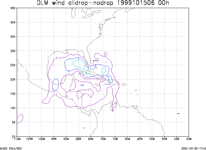
Figure 3. Initial condition differences in the 850 - 200 hPa mean wind between the no and all dropwindsonde cases for 15 October 1999 0600 UTC.
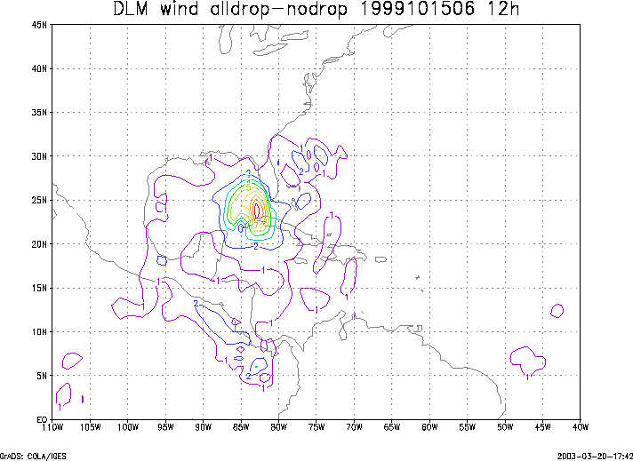
Figure 4. 12-h forecast differences in the 850 - 200 hPa mean wind between the no and all dropwindsonde cases for 15 October 1999 0600 UTC.