Effects of Synoptic Surveillance on model forecasts for
14 October 1999 1800 UTC
IRENE.
QuickTime movie of DLM wind model
forecasts
QuickTime movie of DLM wind data
increments
| TRACK (km) | |||||||||||||||||||||||||||||||||||||||||||||||||||||||||||||||||||||||||||||||||||||||||||||||||||||||||||||||||||||||||||||||||||||||||||||||||||||||||||||||||||||||||||||||||||||||||||||||||||||||||||||||||||
| MODEL | 12 h | 24 h | 36 h | 48 h | 60 h | 72 h | 84 h | 96 h | 108 h | 120 h
|
| AVNN | 122. | 203. | 312. | 320. | 289. | 182.
| AVAL | 89. | 61. | 37. | 56. | 173. | 346.
| %IMP | 27% | 70% | 88% | 83% | 40% | -90%
|
| GFNO | 38. | 111. | 184. | 225. | 285. | 322. | 434. | 1151. | 1345. | 1079.
| GFAL | 24. | 83. | 178. | 147. | 142. | 186. | 357. | 1043. | 1453. | 1093.
| %IMP | 37% | 25% | 3% | 35% | 50% | 42% | 20% | 9% | -8% | -1%
| INTENSITY (kt)
| MODEL | 12 h | 24 h | 36 h | 48 h | 60 h | 72 h | 84 h | 96 h | 108 h | 120 h
|
| AVNN | -34. | -37. | -38. | -37. | -39. | -39.
| AVAL | -24. | -30. | -30. | -29. | -25. | -29.
| %IMP | 29% | 19% | 21% | 22% | 36% | 26%
|
| GFNO | 31. | 24. | 2. | -5. | 2. | -22. | -22. | -55. | -30. | -38.
| GFAL | 21. | 21. | -4. | 2. | 16. | 2. | -35. | -44. | -30. | -39.
| %IMP | 32% | 13% | -100% | 60% | -700% | -91% | -59% | 20% | 0% | -3%
|
| SHNO | 4. | 8. | 10. | 10. | 10. | -1. | -26. | -11. | -13. | -15.
| SHAL | 4. | 8. | 10. | 10. | 10. | -2. | -27. | -11. | -13. | -15.
| %IMP | 0% | 0% | 0% | 0% | 0% | -100% | -4% | 0% | 0% | 0%
|
| DSNO | -11. | -7. | -25. | -34. | -37. | -43. | -68. | -53. | -53. | -53.
| DSAL | -11. | -8. | -25. | -34. | -37. | -43. | -68. | -53. | -53. | -53.
| %IMP | 0% | -14% | 0% | 0% | 0% | 0% | 0% | 0%0% | 0%
| | ||||||||||
| 14/1900 UTC 22.7N 82.5W Batabano, Cuba 1 h into the forecast | |||||||||||||||||||||||||||||||||||||||||||||||||||||||||||||||||||||||||||||||||||||||||||||||||||||||||||||||||||||||||||||||||||||||||||||
| MODEL | LAT | LON | TIME | ERROR | LOCATION
|
| AVNN | 22.58 | 82.82 | 2.0 | 35.4 | Near San Cristobal, Pinar del Rio, Cuba
| AVAL | 22.64 | 82.51 | 1.5 | 6.7 | Batabano, La Habana, Cuba
| %IMP | 50% | 81%
|
| GFNO | 22.67 | 82.43 | 4.0 | 7.9 | Batabano, La Habana, Cuba
| GFAL | 22.67 | 82.40 | 3.5 | 10.8 | Batabano, La Habana, Cuba
| %IMP | 17% | -37%
|
|
|
15/1300 UTC 24.6N 81.6W Key West, FL 19 h into the forecast
| MODEL | LAT | LON | TIME | ERROR | LOCATION
|
| AVNN | 25.03 | 82.36 | 36.5 | 90.3 | Near Key West, FL
| AVAL | 24.56 | 82.10 | 11.5 | 50.7 | Dry Tortugas, FL
| %IMP | 57% | 44%
|
| GFNO | 24.59 | 82.48 | 20.5 | 88.9 | Near Dry Tortugas, FL
| GFAL | 24.61 | 82.03 | 23.0 | 43.4 | Dry Tortugas, FL
| %IMP | -167% | 51%
|
|
15/2000 UTC 25.3N 81.1W Cape Sable, FL 26 h into the forecast
| MODEL | LAT | LON | TIME | ERROR | LOCATION
|
|
| AVNN | 26.01 | 81.76 | 46.5 | 102.9 | Marco, FL
| AVAL | 25.78 | 81.32 | 29.5 | 57.7 | Chokoloskee, FL
| %IMP | 83% | 44%
|
| GFNO | 26.52 | 82.01 | 35.5 | 163.2 | Cape Coral, FL
| GFAL | 25.93 | 81.62 | 35.5 | 87.3 | Goodland, FL
| %IMP | 0% | 47%
| | ||||||||||||||||||||||
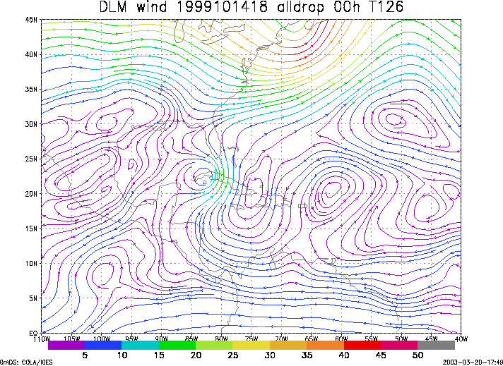
Figure 1. NCEP 850 - 200 hPa mean wind analysis for 14 October 1999 1800 UTC (Tropical Storm Irene).
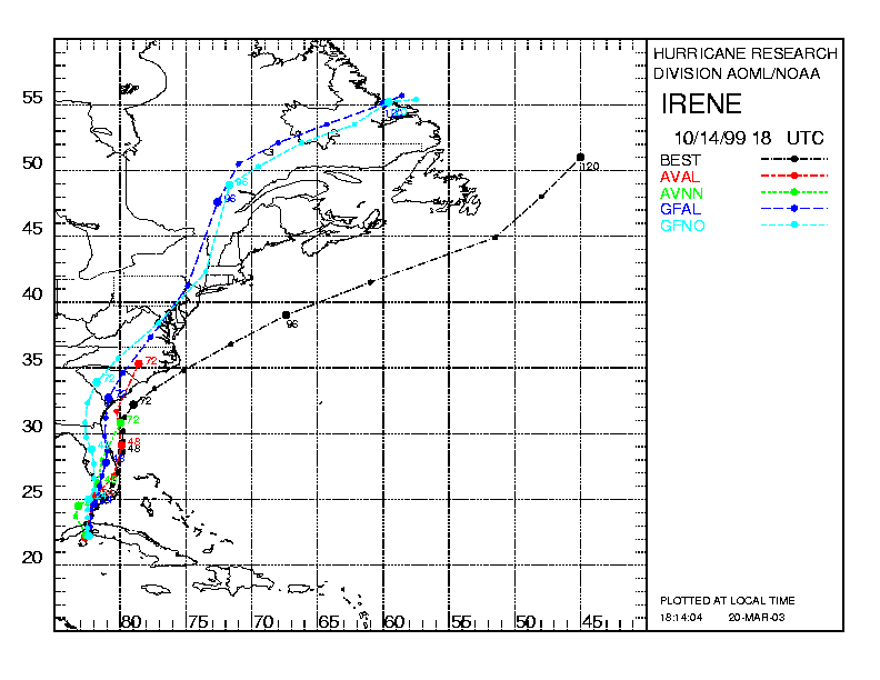
Figure 2. Track forecasts for the no dropwindsonde (NO or NN) and the all dropwindsonde (AL) runs for the AVN and GFDL models initialized on 14 October 1999 1800 UTC. The best track is shown in black.
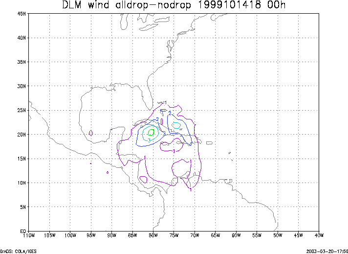
Figure 3. Initial condition differences in the 850 - 200 hPa mean wind between the no and all dropwindsonde cases for 14 October 1999 1800 UTC.
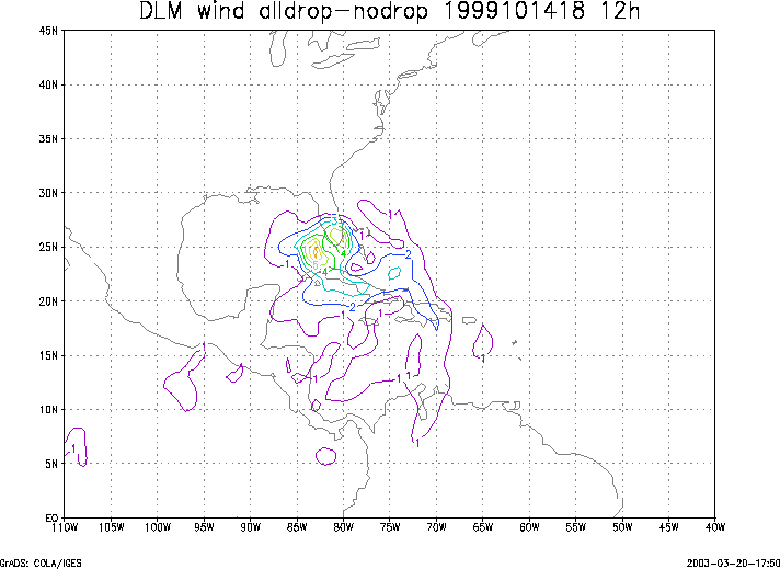
Figure 4. 12-h forecast differences in the 850 - 200 hPa mean wind between the no and all dropwindsonde cases for 14 October 1999 1800 UTC.