Effects of Synoptic Surveillance on model forecasts for
15 September 2000 0000 UTC
GORDON.
QuickTime movie of DLM wind model forecasts
QuickTime movie of DLM wind data increments
| TRACK (km) | ||||||||||||||||||||||||||||||||||||||||||||||||||||||||||||||||||||||||||||||||||||||||||||||||||||||||||||||||||||||||||||||||||||||||||||||||||||||||||||||||||||||||||||||||||||||||||||||||||||||||||||||||||||||||||||||||||||||||||||
| MODEL | 12 h | 24 h | 36 h | 48 h | 60 h | 72 h | 84 h | 96 h | 108 h | 120 h
|
| AVNN | 98. | 84. | 102. | 121. | 201. | 273. | 392. | 614. | 886. | 1169.
| AVAL | 70. | 181. | 171. | 200. | 282. | 333. | 444. | 671. | 971. | 1259.
| %IMP | 29% | -115% | -68% | -65% | -40% | -22% | -13% | -9% | -10% | -8%
|
| GFNO | 11. | dissipated
| GFAL | 78.
| %IMP | -609%
|
| VBNO | 68. | 220. | 316. | 428. | 500. | 462. | 370. | 274. | 256. | 482.
| VBAL | 68. | 224. | 311. | 423. | 482. | 425. | 325. | 211. | 250. | 505.
| %IMP | 0% | -2% | 2% | 1% | 4% | 8% | 12% | 23% | 2% | -5%
| INTENSITY (kt)
| MODEL | 12 h | 24 h | 36 h | 48 h | 60 h | 72 h | 84 h | 96 h | 108 h | 120 h
|
| AVNN | -5. | -13. | -20. | -32. | -28. | -18. | 2. | -2. | 0. | -18.
| AVAL | -4. | -13. | -20. | -31. | -29. | -24. | 2. | 0. | 1. | -18.
| %IMP | 20% | 0% | 0% | 3% | -4% | -33% | 0% | 100% | und% | 0%
|
| GFNO | -2. | dissipated
| GFAL | -6.
| %IMP | -200%
|
| SHNO | 6. | -1. | -7. | -9. | -1. | 7. | 40. | 45. | 51. | 47.
| SHAL | 6. | 0. | -6. | -9. | -1. | 7. | 40. | 45. | 51. | 47.
| %IMP | 0% | 100% | 14% | 0% | 0% | 0% | 0% | 0% | 0% | 0%
|
| DSNO | 0. | -7. | -13. | -15. | -7. | 1. | 34. | 39. | 45. | 41.
| DSAL | 0. | -7. | -13. | -15. | -8. | 0. | 33. | 39. | 44. | 40.
| %IMP | 0% | 0% | 0% | 0% | -14% | 100% | 3% | 0% | 2% | 2%
| | ||||||||||||||||||||||||||||
18/0300 UTC 29.3N 83.2W near Cedar Key, FL 75 h into the forecast
| MODEL | LAT | LON | TIME | ERROR | LOCATION
|
| AVNN | 30.19 | 85.81 | 91.5 | 270.5 | Panama City Beach, FL
| AVAL | 30.27 | 85.99 | 99.5 | 289.8 | Laguna Beach, FL
| %IMP | -40% | -7%
|
| GFNO | 29.88 | 84.61 | 61.5 | 150.7 | Carrabelle, FL
| GFAL | dissipated before landfall
| %IMP
|
| VBNO | 30.03 | 85.38 | 86.0 | 225.5 | Callaway, FL
| VBAL | 29.80 | 85.40 | 74.0 | 219.8 | Port St. Joe, FL
| %IMP | 89% | 3%
| | |||||||||||||
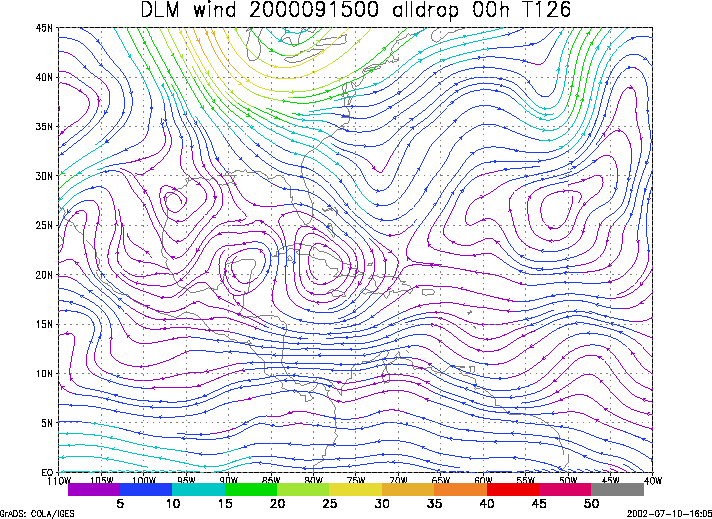
Figure 1. NCEP 850 - 200 hPa mean wind analysis for 15 September 2000 0000 UTC (Tropical Depression Eleven).
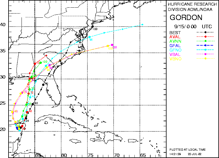
Figure 2. Track forecasts for the no dropwindsonde (NO or NN) and the all dropwindsonde (AL) runs for the AVN, GFDL, and VBAR models initialized on 15 September 2000 0000 UTC. The best track is shown in black.
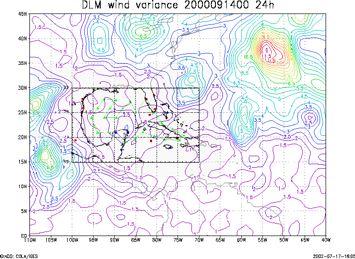
Figure 3. Ensemble perturbation variance at the nominal sampling time 15 September 2000 0000 UTC from the previous day NCEP ensemble forecast. The green circles represent the dropwindsonde locations.
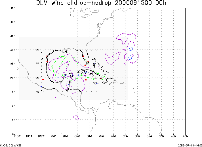
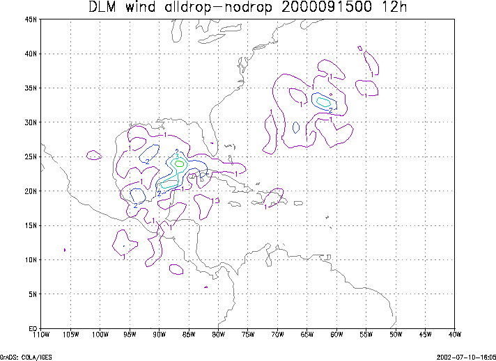
Figure 4. Initial condition differences in the 850 - 200 hPa mean wind between the no and all dropwindsonde cases for 15 September 2000 0000 UTC. The green circles represent the dropwindsonde locations.