Effects of Synoptic Surveillance on model forecasts for
02 September 2004 1800 UTC
Frances.
Quicktime movie of AVN DLM wind model
forecast
Quicktime movie of DLM wind data
increment
| TRACK (km) | ||||||||||||||||||||||||||||||||||||||||||||||||||||||||||||||||||||||||||||||||||||||||||||||||||||||||||||||||||||||||||||||||||||||||||||||||||||||||||||||||||||||||||
| MODEL | 12 h | 24 h | 36 h | 48 h | 60 h | 72 h | 84 h | 96 h | 108 h | 120 h
|
| AVNN | 38 | 24 | 39 | 15 | 32 | 45 | 73 | 0 | 15 | 173
| AVNO | 30 | 39 | 56 | 23 | 60 | 94 | 129 | 40 | 100 | 186
| %IMP | 29% | -63% | -44% | -53% | -88% | -109% | -77% | und% | -567% | -9%
|
| GFNO | 11 | 75 | 35 | 73 | 98 | 148 | 226 | 191 | 221 | 370
| GFDL | 23 | 35 | 39 | 24 | 37 | 99 | 161 | 135 | 104 | 171
| %IMP | -109% | 53% | 11% | 67% | 62% | 33% | 29% | 29% | 53% | 54%
|
| INTENSITY (kt)
| MODEL | 12 h | 24 h | 36 h | 48 h | 60 h | 72 h | 84 h | 96 h | 108 h | 120 h
|
| AVNN | -55 | -47 | -32 | -22 | -24 | -2 | -6 | 1 | 0 | -4
| AVNO | -26 | -23 | -9 | -11 | -17 | 2 | -1 | 4 | -2 | -3
| %IMP | 53% | 51% | 72% | 50% | 29% | 0% | 83% | -300% | und% | 25%
|
| GFNO | 15 | 18 | 21 | 19 | 7 | 36 | 29 | 24 | 11 | 18
| GFDL | 5 | 12 | 20 | 12 | 3 | 22 | 26 | 28 | 12 | 10
| %IMP | 67% | 33% | 5% | 37% | 57% | 39% | 10% | -16% | -9% | 44%
|
| | ||||||||||
| 03/0530 UTC 24.6N 75.6W Northern end of Cat Island, Bahamas 11.5 h into the forecast | |||||||||||||||||||||||||||||||||||||||||||||||||||||||||||||||||||||||||||||||||||||||||||||||||||||||||||||||||||||||||||||||||||||||||||||||||||||||||||||||||||||||||||||||||||||||||||||||||||||||||||||||||||||||||||||||||||||||||||
| MODEL | LAT | LON | TIME | ERROR | LOCATION
|
| AVNN | 24.52 | 75.59 | 8.5 | 8.9 | Cat Island, Bahamas
| AVNO | 24.66 | 75.64 | 9.5 | 7.8 | Cat Island, Bahamas
| %IMP | 33% | 12%
|
| GFNO | 24.68 | 75.62 | 11.0 | 9.1 | Cat Island, Bahamas
| GFDL | 24.49 | 75.56 | 9.0 | 12.9 | Cat Island, Bahamas
| %IMP | -400% | -42%
|
|
03/1000 UTC 25.1N 76.1W Eleuthera Island, Bahamas 16.0 h into the forecast
| MODEL | LAT | LON | TIME | ERROR | LOCATION
|
| AVNN | 25.17 | 76.26 | 14.5 | 17.9 | Eleuthera Island, Bahamas
| AVNO | 25.22 | 76.24 | 15.5 | 19.4 | Eleuthera Island, Bahamas
| %IMP | 67% | -8%
|
| GFNO | 25.22 | 75.96 | 15.5 | 19.4 | Eleuthera Island, Bahamas
| GFDL | 25.01 | 76.12 | 14.0 | 10.2 | Eleuthera Island, Bahamas
| %IMP | -300% | 47%
|
04/1000 UTC 26.6N 78.2W Grand Bahama Island, Bahamas 40.0 h into the forecast
| MODEL | LAT | LON | TIME | ERROR | LOCATION
|
| AVNN | 26.65 | 78.63 | 43.0 | 43.1 | Grand Bahama Island, Bahamas
| AVNO | 26.88 | 77.96 | 35.5 | 39.2 | Grand Bahama Island, Bahamas
| %IMP | -50% | 9%
|
| GFNO | 26.76 | 77.89 | 37.0 | 35.5 | Grand Bahama Island, Bahamas
| GFDL | 26.70 | 78.10 | 36.0 | 14.9 | Grand Bahama Island, Bahamas
| %IMP | -33% | 58%
|
|
05/0430 UTC 27.2N 80.2W South end of Hutchinson Island, FL 58.5 h into the forecast
| MODEL | LAT | LON | TIME | ERROR | LOCATION
|
| AVNN | 27.18 | 80.20 | 62.0 | 2.2 | Port St. Lucie, FL
| AVNO | 27.80 | 80.41 | 68.0 | 69.8 | Sebastian, FL
| %IMP | -171% | -3073%
|
| GFNO | 28.97 | 80.86 | 73.5 | 207.0 | Port Orange, FL
| GFDL | 27.72 | 80.38 | 66.0 | 60.4 | Vero Beach, FL
| %IMP | 50% | 71%
|
06/1800 UTC 30.1N 84.0W Mouth of Aucilla River, FL 96.0 h into the forecast
| MODEL | LAT | LON | TIME | ERROR | LOCATION
|
| AVNN | 30.10 | 84.00 | 95.0 | 0.0 | Mandalay, FL
| AVNO | No landfall forecast
| %IMP | |
|
| GFNO | No landfall forecast
| GFDL | No landfall forecast
| %IMP | |
| | ||||||||||||||||||||||||||||||||||||||||||||||||||||
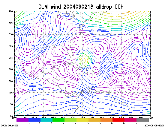
Figure 1. NCEP 850 - 200 hPa mean wind analysis for 02 September 2004 1800 UTC (Hurricane Frances).
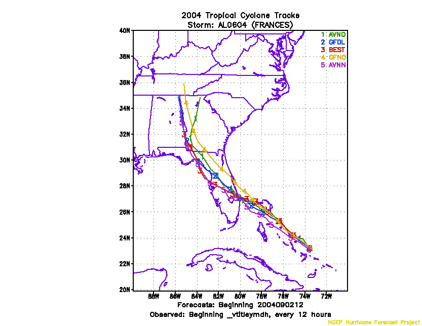
Figure 2. Track forecasts for the no dropwindsonde (NO or NN) and the all dropwindsonde (AL) runs for the AVN and GFDL models initialized on 02 September 2004 1800 UTC.
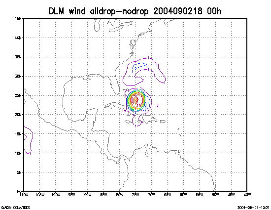
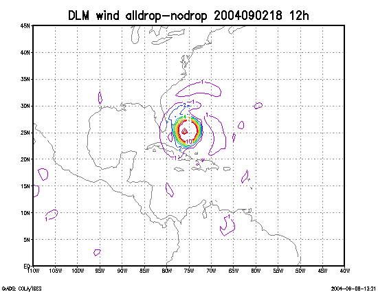
Figure 3. Initial condition differences in the 850 - 200 hPa mean wind between the no and all dropwindsonde cases for 02 September 2004 1800 UTC.