Effects of Synoptic Surveillance on model forecasts for
31 August 2004 0000 UTC
Frances.
Quicktime movie of AVN DLM wind model
forecast
Quicktime movie of DLM wind data
increment
| TRACK (km) | ||||||||||||||||||||||||||||||||||||||||||||||||||||||||||||||||||||||||||||||||||||||||||||||||||||||||||||||||||||||||||||||||||||||||||||||||||||||||||||||||||||||||||
| MODEL | 12 h | 24 h | 36 h | 48 h | 60 h | 72 h | 84 h | 96 h | 108 h | 120 h
|
| AVNN | 43 | 76 | 108 | 169 | 202 | 219 | 212 | 237 | 201 | 316
| AVNO | 43 | 46 | 67 | 88 | 153 | 209 | 229 | 230 | 311 | 400
| %IMP | 0% | 39% | 38% | 48% | 24% | 5% | -8% | 3% | -55% | -27%
|
| GFNO | 46 | 54 | 102 | 144 | 212 | 255 | 278 | 370 | 460 | 662
| GFDL | 38 | 39 | 56 | 124 | 204 | 237 | 273 | 342 | 403 | 587
| %IMP | 17% | 25% | 48% | 14% | 4% | 7% | 2% | 8% | 12% | 11%
|
| INTENSITY (kt)
| MODEL | 12 h | 24 h | 36 h | 48 h | 60 h | 72 h | 84 h | 96 h | 108 h | 120 h
|
| AVNN | -77 | -81 | -78 | -75 | -80 | -67 | -49 | -35 | -36 | -29
| AVNO | -72 | -73 | -75 | -70 | -77 | -60 | -35 | -29 | -21 | -17
| %IMP | 6% | 10% | 4% | 7% | 4% | 10% | 29% | 17% | 42% | 41%
|
| GFNO | -6 | -8 | -5 | -8 | -21 | -19 | -7 | 4 | -4 | 1
| GFDL | 2 | -1 | -6 | -5 | -17 | -17 | -9 | 0 | -2 | -3
| %IMP | 67% | 88% | -20% | 38% | 19% | 11% | -29% | 100% | 50% | -200%
|
| | ||||||||||
| 02/1930 UTC 24.0N 74.5W San Salvador Island, Bahamas 67.5 h into the forecast | ||||||||||||||||||||||||||||||||||||||||||||||||||||||||||||||||||||||||||||||||||||||||||||||||||||||||||||||||||||||||||||||||||||||||||||||||||||||||||||||||||||||||||||||||||||||||||||||||||||||||||||||||||||||||||||||||||||||||||||||||||||||||||||||||||||||||||||||||||||||||||||||||||
| MODEL | LAT | LON | TIME | ERROR | LOCATION
|
| AVNN | 25.09 | 73.30 | 61.0 | 171.4 | Well offshore San Salvador Island, Bahamas
| AVNO | 24.98 | 73.17 | 65.5 | 173.0 | Well offshore San Salvador Island, Bahamas
| %IMP | 69% | -1%
|
| GFNO | 25.16 | 73.37 | 60.5 | 172.2 | Well offshore San Salvador Island, Bahamas
| GFDL | 25.23 | 73.37 | 62.0 | 178.0 | Well offshore San Salvador Island, Bahamas
| %IMP | 21% | -4%
|
|
03/0530 UTC 24.6N 75.6W Northern end of Cat Island, Bahamas 77.5 h into the forecast
| MODEL | LAT | LON | TIME | ERROR | LOCATION
|
| AVNN | 25.09 | 73.30 | 61.0 | 238.2 | Well offshore San Salvador Island, Bahamas
| AVNO | 26.51 | 74.42 | 78.0 | 242.9 | Well offshore Eleuthera Island, Bahamas
| %IMP | 97% | 2%
|
| GFNO | 25.16 | 73.37 | 60.5 | 233.2 | Well offshore San Salvador Island, Bahamas
| GFDL | 26.36 | 74.55 | 72.5 | 222.1 | Well offshore Eleuthera Island, Bahamas
| %IMP | 71% | 5%
|
|
03/1000 UTC 25.1N 76.1W Eleuthera Island, Bahamas 82.0 h into the forecast
| MODEL | LAT | LON | TIME | ERROR | LOCATION
|
| AVNN | 27.37 | 75.87 | 87.5 | 253.2 | Well offshore Abaco Island, Bahamas
| AVNO | 26.51 | 74.42 | 78.0 | 229.7 | Well offshore Eleuthera Island, Bahamas
| %IMP | 27% | 9%
|
| GFNO | 27.46 | 75.90 | 81.0 | 263.0 | Well offshore Abaco Island, Bahamas
| GFDL | 26.36 | 74.55 | 72.5 | 158.4 | Well offshore Eleuthera Island, Bahamas
| %IMP | -850% | 40%
|
|
|
04/1000 UTC 26.6N 78.2W Grand Bahama Island, Bahamas 106.0 h into the forecast
| MODEL | LAT | LON | TIME | ERROR | LOCATION
|
| AVNN | 28.14 | 77.06 | 105.5 | 204.8 | Well offshore Abaco Island, Bahamas
| AVNO | 27.30 | 75.70 | 96.0 | 259.5 | Well offshore Abaco Island, Bahamas
| %IMP | -1900% | -27%
|
| GFNO | 27.46 | 75.90 | 81.0 | 315.8 | Well offshore Abaco Island, Bahamas
| GFDL | 27.53 | 75.56 | 82.5 | 346.0 | Well offshore Abaco Island, Bahamas
| %IMP | 6% | -10%
|
|
|
05/0430 UTC 27.2N 80.2W South end of Hutchinson Island, FL 124.5 h into the forecast
| MODEL | LAT | LON | TIME | ERROR | LOCATION
|
| AVNN | No landfall forecast
| AVNO | No landfall forecast
| %IMP | |
|
| GFNO | No landfall forecast
| GFDL | No landfall forecast
| %IMP | |
|
|
|
06/1800 UTC 30.1N 84.0W Mouth of Aucilla River, FL 162.0 h into the forecast
| MODEL | LAT | LON | TIME | ERROR | LOCATION
|
| AVNN | No landfall forecast
| AVNO | No landfall forecast
| %IMP | |
|
| GFNO | No landfall forecast
| GFDL | No landfall forecast
| %IMP | |
|
| | |||||||||||||||||||||||||||||||||||||||||||||||||||||||||||||||||||||||||||||||||
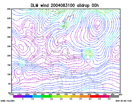
Figure 1. NCEP 850 - 200 hPa mean wind analysis for 31 August 2004 0000 UTC (Hurricane Frances).
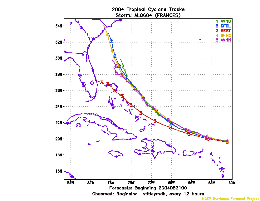
Figure 2. Track forecasts for the no dropwindsonde (NO or NN) and the all dropwindsonde (AL) runs for the AVN and GFDL models initialized on 31 August 2004 0000 UTC.
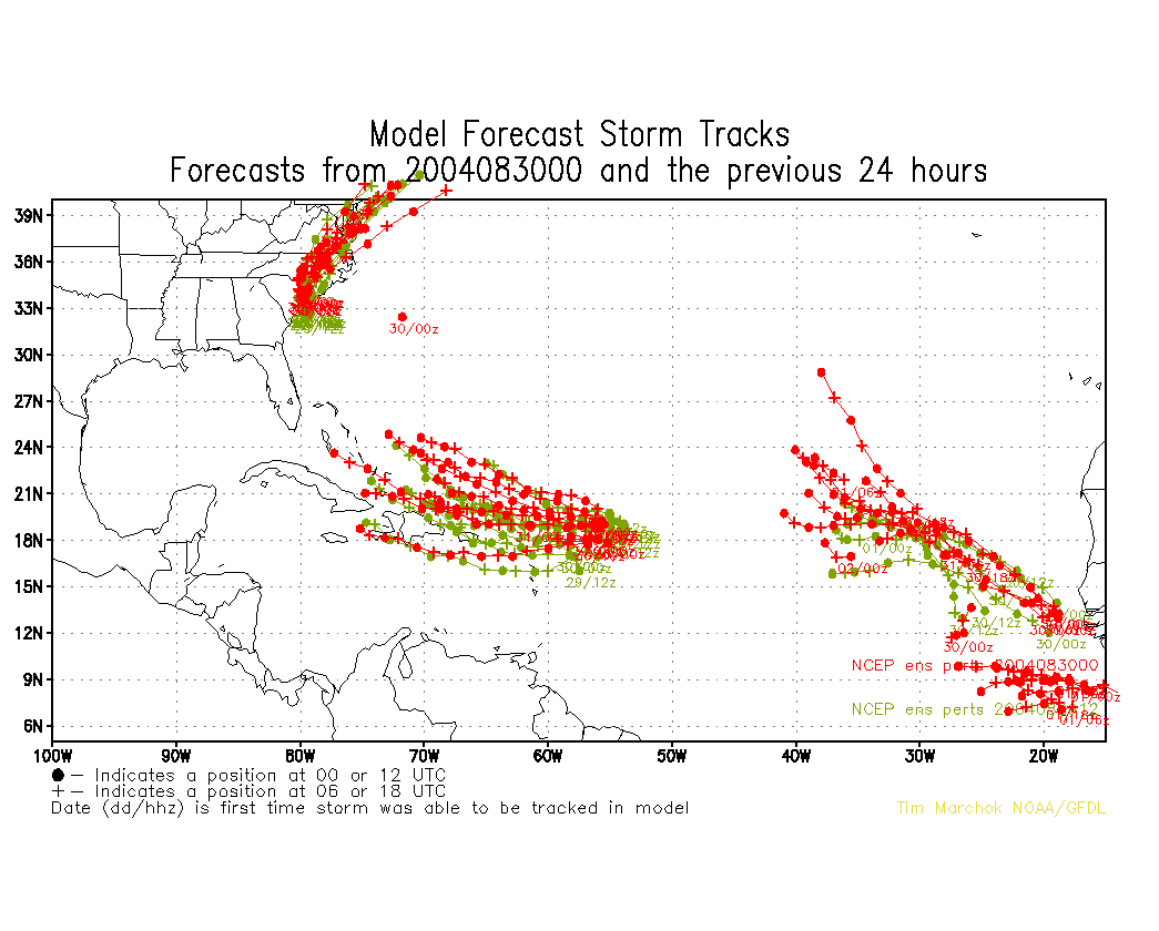
Figure 3. NCEP Global Ensemble Predction System track forecasts for all cyclones in the Atlantic basin initialized from 29 August 2004 0600 UTC to 30 August 2004 0000 UTC, showing the tracks of Hurricane Frances.
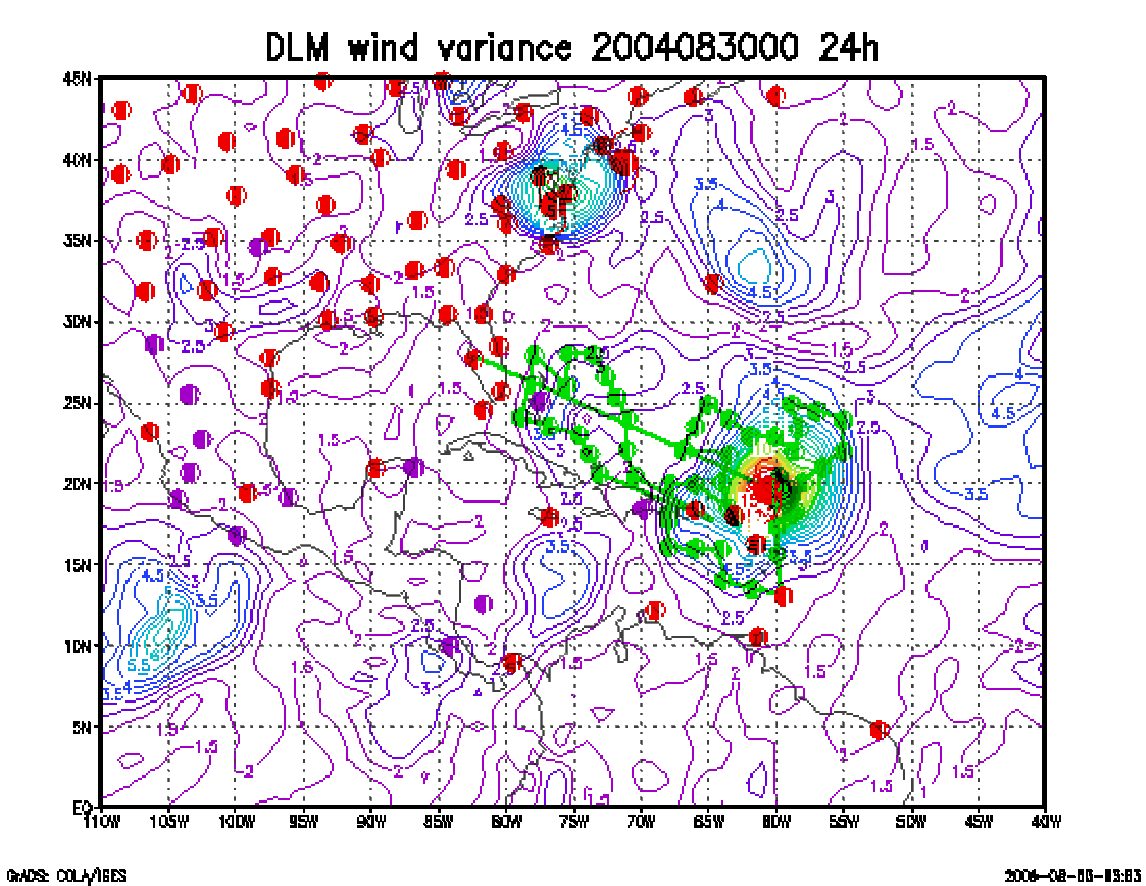
Figure 4. Ensemble perturbation variance at the nominal sampling time 31 August 2004 0000 UTC from the previous day NCEP ensemble forecast. The green circles represent the dropwindsonde locations.
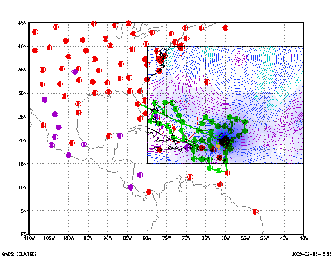
Figure 5. Variance explained within the verification region (large red circle) for observations taken at the sampling time 31 August 2004 0000 UTC from the Ensemble Transform Kalman Filter run from the previous day NCEP ensemble forecast. The green circles represent the dropwindsonde locations.
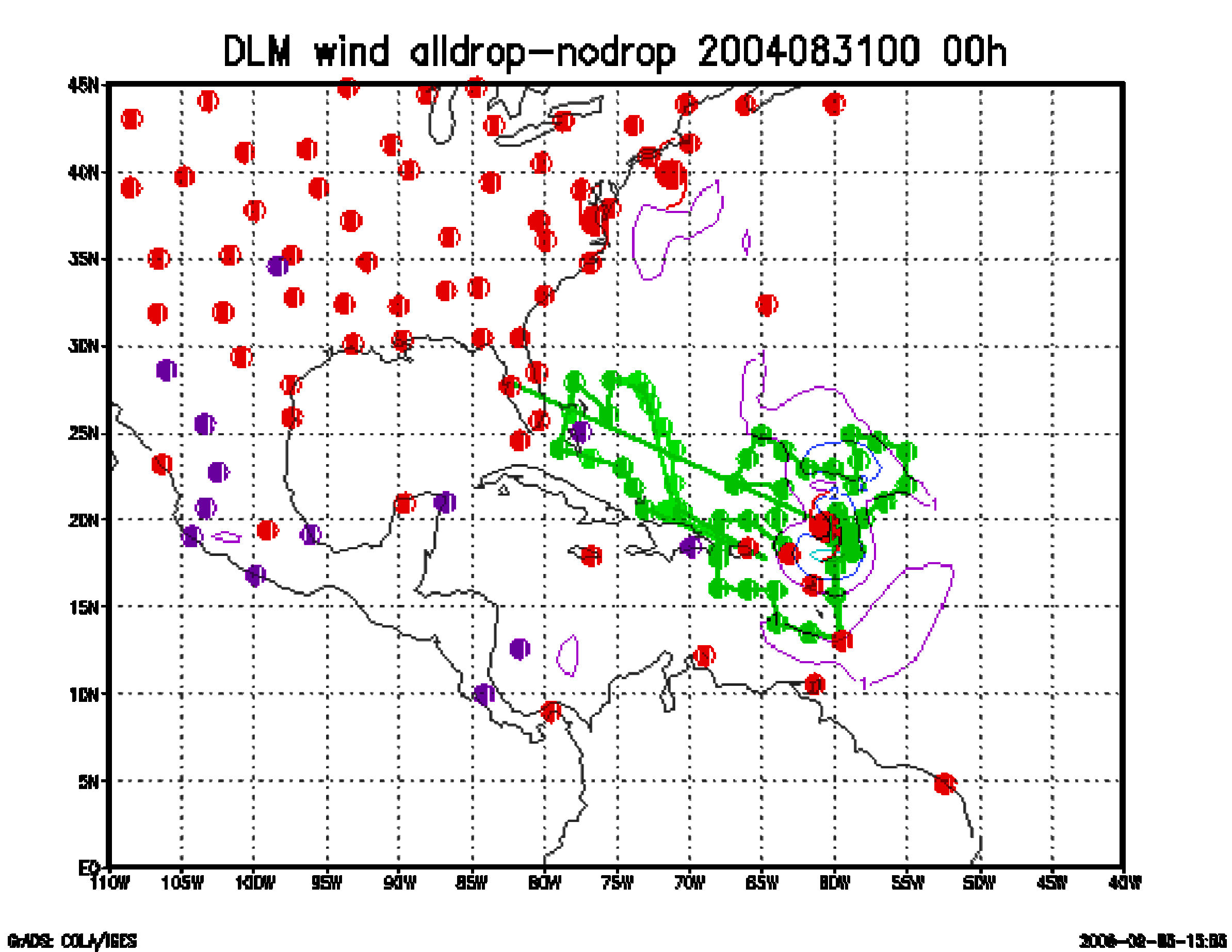
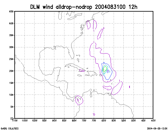
Figure 6. Initial condition differences in the 850 - 200 hPa mean wind between the no and all dropwindsonde cases for 31 August 2004 0000 UTC. The circles represent the dropwindsonde locations.