Effects of Synoptic Surveillance on model forecasts for
29 August 2006 1800 UTC
Ernesto.
Quicktime movie of AVN DLM wind model
forecast
Quicktime movie of DLM wind data
increment
| TRACK (km) | ||||||||||||||||||||||||||||||||||||||||||||||||||||||||||||||||||||||||||||||||||||||||||||||||||||||||||||||||||||||||||||||||||||||||||||||||||||||||||||||||||||
| MODEL | 12 h | 24 h | 36 h | 48 h | 60 h | 72 h | 84 h | 96 h | 108 h | 120 h
| AVNN | 15 | 30 | 59 | 72 | 51 | 69 | 153 | 170 | 159 |
| AVNO | 30 | 32 | 44 | 86 | 78 | 93 | 119 | 112 | 155 |
| %IMP | -100% | -7% | 25% | -19% | -53% | -35% | 22% | 34% | 3% |
| GFNO | 40 | 35 | 22 | 58 | 171 | 283 | 505 | 633 | 531 | 293
| GFDL | 60 | 49 | 22 | 87 | 155 | 230 | 480 | 632 | 569 | 459
| %IMP | -50% | -40% | 0% | -50% | 9% | 19% | 5% | 0% | -7% | -57%
| INTENSITY (kt)
| MODEL | 12 h | 24 h | 36 h | 48 h | 60 h | 72 h | 84 h | 96 h | 108 h | 120 h
| AVNN | -9 | -5 | -13 | -24 | -13 | 0 | -17 | -20 | -5 |
| AVNO | -9 | -4 | -12 | -25 | -16 | 7 | -10 | -4 | 8 |
| %IMP | 0% | 20% | 8% | -4% | -23% | und% | 41% | 80% | -60% |
| GFNO | 6 | 20 | 11 | 8 | -4 | -14 | 13 | 2 | 13 | 10
| GFDL | 4 | 15 | 7 | 9 | -5 | -11 | 16 | 4 | 4 | -3
| %IMP | 33% | 25% | 36% | -13% | -25% | 21% | -23% | -100% | 69% | 70%
| | ||||||||||
| 30/0300 UTC 24.9N 80.6W Plantation Key, FL, 9 h into the forecast | |||||||||||||||||||||||||||||||||||||||||||||||||||||||||||||||||||||||||||||||||||||||||||||||||||||||||||||||||||||||||||||||||||
| MODEL | LAT | LON | TIME | ERROR | LOCATION
| AVNN | 24.81 | 80.74 | 9.0 | 17.3 | Layton, FL
| AVNO | 24.77 | 80.86 | 9.5 | 29.9 | Duck Key, FL
| %IMP | und% | -73%
| GFNO | 24.75 | 80.92 | 6.5 | 36.8 | Duck Key, FL
| GFDL | 24.70 | 81.13 | 10.0 | 57.9 | Marathon, FL
| %IMP | 60% | -57%
|
30/0500 UTC 25.2N 80.7W Southwestern Miami-Dade County, FL, 11 h into the forecast
| MODEL | LAT | LON | TIME | ERROR | LOCATION
| AVNN | 25.27 | 80.92 | 12.5 | 23.4 | Flamingo, FL
| AVNO | 25.24 | 81.05 | 13.0 | 35.5 | Flamingo, FL
| %IMP | -25% | -52%
| GFNO | 25.25 | 81.19 | 11.5 | 49.6 | Flamingo, FL
| GFDL | 25.24 | 81.25 | 15.0 | 55.5 | Flamingo, FL
| %IMP | -700% | -12%
|
01/0340 UTC 33.9N 78.1W Oak Island, NC, 57.75 h into the forecast
| MODEL | LAT | LON | TIME | ERROR | LOCATION
| AVNN | 33.00 | 79.41 | 51.5 | 157.3 | McClellanville, SC
| AVNO | 32.82 | 79.73 | 50.0 | 193.1 | Isle of Pines, SC
| %IMP | -24% | -23%
| GFNO | 32.98 | 79.63 | 51.0 | 174.8 | Bull Bay, SC
| GFDL | 32.81 | 79.91 | 50.0 | 207.1 | Charleston, SC
| %IMP | -15% | -18%
| | ||||||||||||||||||||||
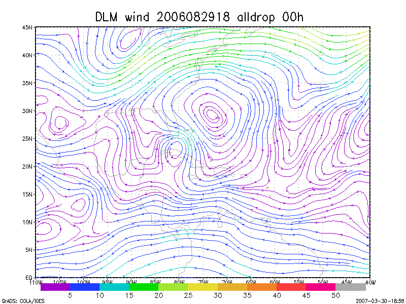
Figure 1. NCEP 850 - 200 hPa mean wind analysis for 29 August 2006 1800 UTC (Tropical Storm Ernesto).
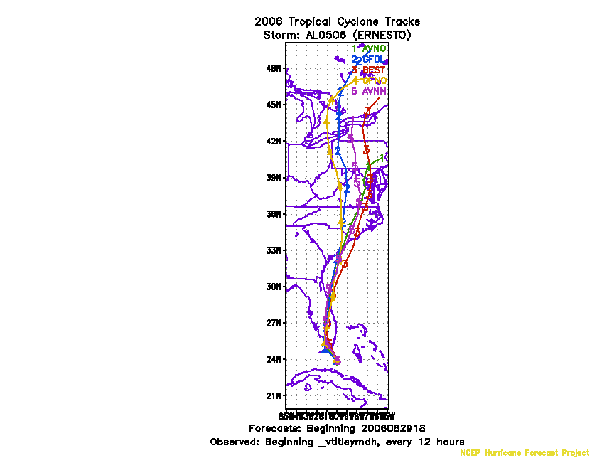
Figure 2. Track forecasts for the no dropwindsonde (NO or NN) and the all dropwindsonde (AL) runs for the AVN and GFDL models initialized on 29 August 2006 1800 UTC.
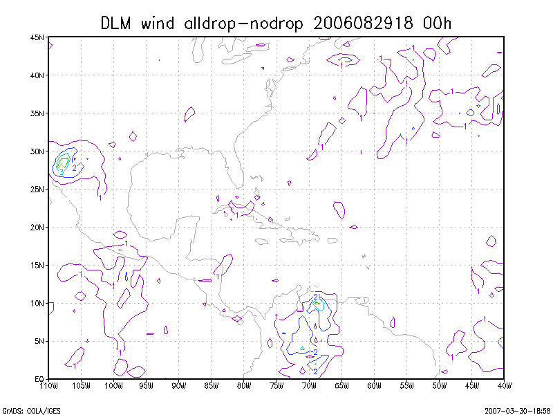
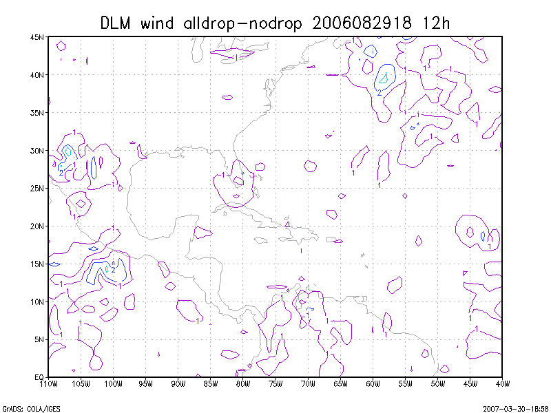
Figure 3. Initial condition differences in the 850 - 200 hPa mean wind between the no and all dropwindsonde cases for 29 August 2006 1800 UTC.