Effects of Synoptic Surveillance on model forecasts for
28 August 2006 0600 UTC
Ernesto.
Quicktime movie of AVN DLM wind model
forecast
Quicktime movie of DLM wind data
increment
| TRACK (km) | ||||||||||||||||||||||||||||||||||||||||||||||||||||||||||||||||||||||||||||||||||||||||||||||||||||||||||||||||||||||||||||||||||||||||||||||||||||||||||||||||||||
| MODEL | 12 h | 24 h | 36 h | 48 h | 60 h | 72 h | 84 h | 96 h | 108 h | 120 h
| AVNN | 33 | 102 | 75 | 78 | 107 | 69 | 24 | 105 | 267 | 404
| AVNO | 24 | 83 | 52 | 50 | 53 | 29 | 104 | 166 | 216 | 374
| %IMP | 27% | 19% | 31% | 36% | 50% | 58% | -333% | -58% | 21% | 7%
| GFNO | 44 | 98 | 56 | 75 | 128 | 176 | 233 | 403 | 619 | 765
| GFDL | 63 | 103 | 52 | 71 | 23 | 68 | 142 | 293 | 520 | 723
| %IMP | -43% | -5% | 7% | 5% | 82% | 61% | 39% | 27% | 16% | 5%
| INTENSITY (kt)
| MODEL | 12 h | 24 h | 36 h | 48 h | 60 h | 72 h | 84 h | 96 h | 108 h | 120 h
| AVNN | -8 | -5 | -8 | -7 | -6 | -15 | -29 | -23 | -17 | -21
| AVNO | -6 | -2 | -6 | -6 | -2 | -13 | -30 | -20 | -15 | -22
| %IMP | 26% | 60% | 25% | 14% | 67% | 13% | -3% | 13% | 12% | -5%
| GFNO | 13 | 5 | 13 | 31 | 22 | 11 | 1 | -15 | -16 | -22
| GFDL | 17 | 8 | 24 | 34 | 19 | 14 | 17 | -8 | -7 | -8
| %IMP | -31% | -60% | -85% | -10% | 14% | -27% | -1600% | 47% | 56% | 64%
| | ||||||||||
| 28/1115 UTC 19.9N 75.5W Playa Cazonal, Cuba, 5.25 h into the forecast | |||||||||||||||||||||||||||||||||||||||||||||||||||||||||||||||||||||||||||||||||||||||||||||||||||||||||||||||||||||||||||||||||||||||||||||||||||||||||||||||||||||||||||||||||
| MODEL | LAT | LON | TIME | ERROR | LOCATION
| AVNN | 19.85 | 75.47 | 5.5 | 6.4 | Santiago de Cuba, Santiago de Cuba, Cuba
| AVNO | 20.01 | 76.14 | 7.0 | 67.9 | Santiago de Cuba, Santiago de Cuba, Cuba
| %IMP | -600% | -1061%
| GFNO | 19.97 | 75.87 | 7.5 | 39.4 | Santiago de Cuba, Santiago de Cuba, Cuba
| GFDL | 19.90 | 75.33 | 6.0 | 17.8 | Near Guantanamo, Santiago de Cuba, Cuba
| %IMP | 67% | 55%
|
30/0300 UTC 24.9N 80.6W Plantation Key, FL, 45 h into the forecast
| MODEL | LAT | LON | TIME | ERROR | LOCATION
| AVNN | 25.42 | 80.22 | 44.5 | 69.3 | Ocean Reef Club, FL
| AVNO | 25.37 | 80.32 | 48.5 | 59.3 | Ocean Reef Club, FL
| %IMP | -600% | 14%
| GFNO | 24.68 | 81.21 | 47.0 | 66.2 | Marathon, FL
| GFDL | 25.50 | 80.20 | 50.0 | 77.8 | Key Largo, FL
| %IMP | -150% | -18%
|
30/0500 UTC 25.2N 80.7W Southwestern Miami-Dade County, FL, 47 h into the forecast
| MODEL | LAT | LON | TIME | ERROR | LOCATION
| AVNN | 25.62 | 80.31 | 46.0 | 60.9 | Perrine, FL
| AVNO | 25.37 | 80.32 | 48.5 | 42.6 | Ocean Reef Club, FL
| %IMP | -50% | 30%
| GFNO | 26.12 | 81.95 | 58.0 | 162.6 | Naples, FL
| GFDL | 25.50 | 80.20 | 50.0 | 55.0 | Key Largo, FL
| %IMP | 73% | 66%
|
01/0340 UTC 33.9N 78.1W Oak Island, NC, 93.75 h into the forecast
| MODEL | LAT | LON | TIME | ERROR | LOCATION
| AVNN | 33.88 | 78.54 | 98.0 | 40.6 | Sunset Beach, NC
| AVNO | 32.50 | 80.13 | 85.5 | 244.6 | Folly Beach, NC
| %IMP | -94% | -502%
| GFNO | 30.78 | 81.59 | 81.5 | 476.9 | Fernandina Beach, FL
| GFDL | 32.16 | 80.71 | 85.5 | 310.6 | Hilton Head Island, SC
| %IMP | 33% | 35%
| | |||||||||||||||||||||||||||||||
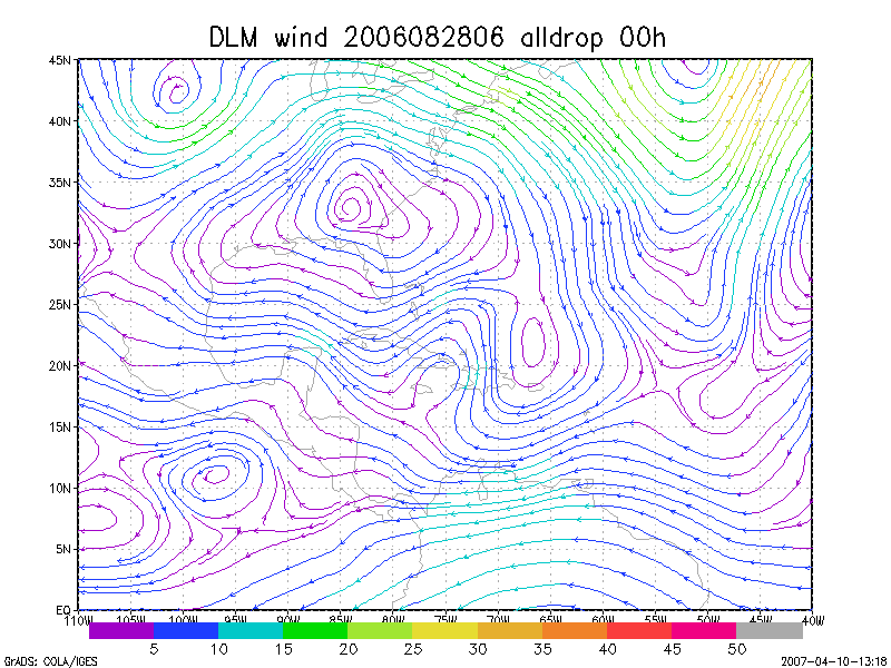
Figure 1. NCEP 850 - 200 hPa mean wind analysis for 28 August 2006 0600 UTC (Tropical Storm Ernesto).
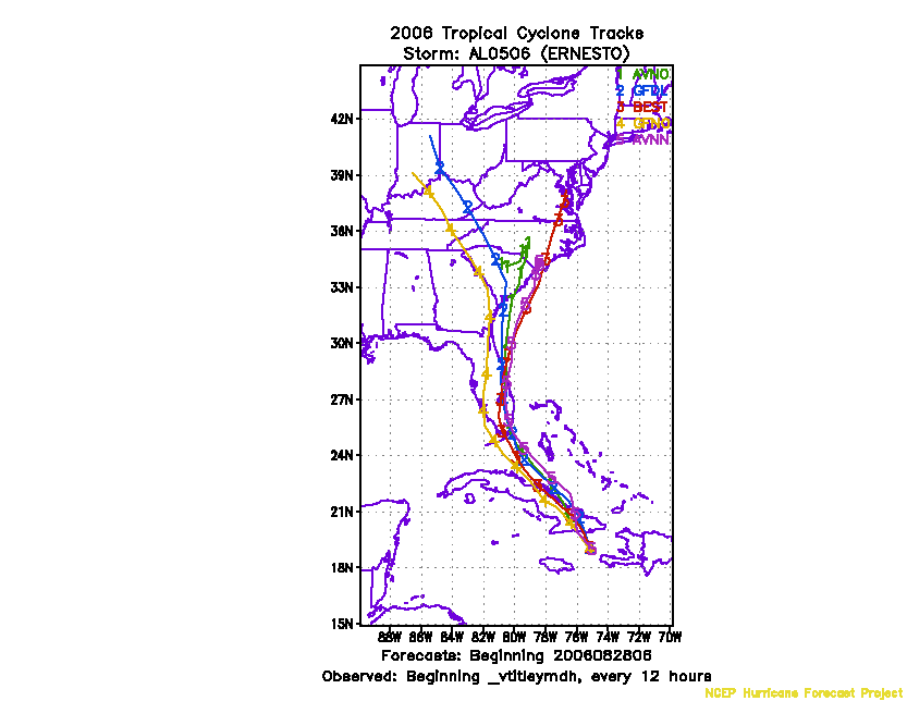
Figure 2. Track forecasts for the no dropwindsonde (NO or NN) and the all dropwindsonde (AL) runs for the AVN and GFDL models initialized on 28 August 2006 0600 UTC.
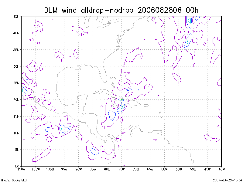
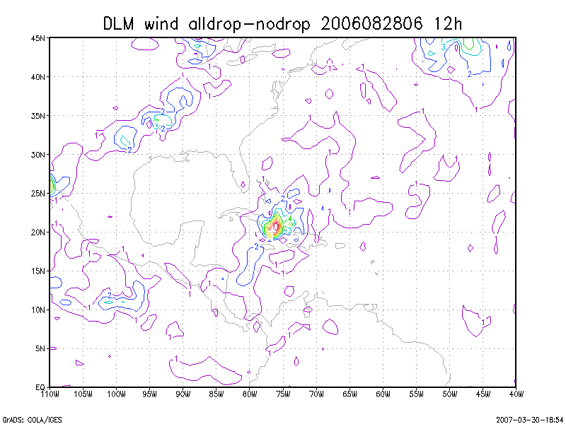
Figure 3. Initial condition differences in the 850 - 200 hPa mean wind between the no and all dropwindsonde cases for 28 August 2006 0600 UTC.