Effects of Synoptic Surveillance on model forecasts for
28 August 2006 0000 UTC
Ernesto.
Quicktime movie of AVN DLM wind model
forecast
Quicktime movie of DLM wind data
increment
| TRACK (km) | |||||||||||||||||||||||||||||||||||||||||||||||||||||||||||||||||||||||||||||||||||||||||||||||||||||||||||||||||||||||||||||||||||||||||||||||||||||||||||||||||||||
| MODEL | 12 h | 24 h | 36 h | 48 h | 60 h | 72 h | 84 h | 96 h | 108 h | 120 h
| AVNN | 43 | 61 | 56 | 35 | 35 | 59 | 67 | 163 | 261 | 148
| AVNO | 33 | 84 | 61 | 32 | 46 | 66 | 176 | 321 | 388 | 300
| %IMP | 23% | -38% | -9% | 9% | -31% | -12% | -163% | -97% | -49% | -103%
| GFNO | 49 | 61 | 63 | 74 | 114 | 155 | 189 | 318 | 530 | 593
| GFDL | 15 | 61 | 93 | 80 | 80 | 102 | 124 | 202 | 306 | 420
| %IMP | 69% | 0% | -48% | -8% | 30% | 34% | 34% | 36% | 42% | 29%
| INTENSITY (kt)
| MODEL | 12 h | 24 h | 36 h | 48 h | 60 h | 72 h | 84 h | 96 h | 108 h | 120 h
|
| AVNN | -9 | -1 | -6 | -10 | -6 | -7 | -20 | -30 | -1 | -4
| AVNO | -2 | -3 | -5 | -9 | -2 | -5 | -24 | -34 | -3 | -11
| %IMP | 78% | -200% | 17% | 10% | 67% | 29% | -20% | -13% | -200% | -175%
| GFNO | 18 | 17 | 6 | 19 | 22 | 16 | 4 | -10 | -6 | -22
| GFDL | 12 | 13 | 7 | 19 | 31 | 25 | 15 | 8 | 14 | -19
| %IMP | 33% | 24% | -17% | 0% | -41% | -56% | -275% | 20% | -133% | 14%
| | ||||||||||
| 28/1115 UTC 19.9N 75.5W Playa Cazonal, Cuba, 11.25 h into the forecast | |||||||||||||||||||||||||||||||||||||||||||||||||||||||||||||||||||||||||||||||||||||||||||||||||||||||||||||||||||||||||||||||||||||||||||||||||||||||||||||||||||||||||||||||
| MODEL | LAT | LON | TIME | ERROR | LOCATION
| AVNN | 19.98 | 76.03 | 12.5 | 56.1 | Santiago de Cuba, Santiago de Cuba, Cuba
| AVNO | 19.96 | 75.74 | 10.0 | 25.9 | Santiago de Cuba, Santiago de Cuba, Cuba
| %IMP | 0% | 54%
| GFNO | 19.98 | 76.04 | 15.0 | 57.1 | antiago de Cuba, Santiago de Cuba, Cuba
| GFDL | 19.90 | 75.50 | 12.0 | 52.2 | Near Guantanamo, Santiago de Cuba, Cuba
| %IMP | 80% | 9%
|
30/0300 UTC 24.9N 80.6W Plantation Key, FL, 51 h into the forecast
| MODEL | LAT | LON | TIME | ERROR | LOCATION
| AVNN | 25.00 | 80.50 | 48.0 | 15.0 | Tavernier, FL
| AVNO | 25.00 | 80.51 | 53.0 | 14.3 | Tavernier, FL
| %IMP | 67% | 5%
| GFNO | 24.71 | 81.06 | 49.5 | 51.0 | Marathon, FL
| GFDL | 24.87 | 80.66 | 55.5 | 6.9 | Islamorada, FL
| %IMP | -200% | 86%
|
30/0500 UTC 25.2N 80.7W Southwestern Miami-Dade County, FL, 53 h into the forecast
| MODEL | LAT | LON | TIME | ERROR | LOCATION
| AVNN | 25.20 | 80.64 | 50.0 | 6.0 | Florida City, FL
| AVNO | 25.17 | 80.64 | 55.0 | 6.9 | Florida City, FL
| %IMP | 33% | -15%
| GFNO | 25.04 | 81.30 | 52.0 | 62.9 | Flamingo, FL
| GFDL | 25.16 | 80.75 | 58.0 | 6.7 | Florida City, FL
| %IMP | -400% | 89%
|
01/0340 UTC 33.9N 78.1W Oak Island, NC, 99.75 h into the forecast
| MODEL | LAT | LON | TIME | ERROR | LOCATION
| AVNN | 32.60 | 80.00 | 96.0 | 228.1 | Folly Beach, SC
| AVNO | No landfall forecast
| %IMP |
| GFNO | No landfall forecast
| GFDL | 32.50 | 80.40 | 96.0 | 264.4 | Edisto Beach, SC
| %IMP |
| | |||||||||||||||||||||||||||||||||||||||
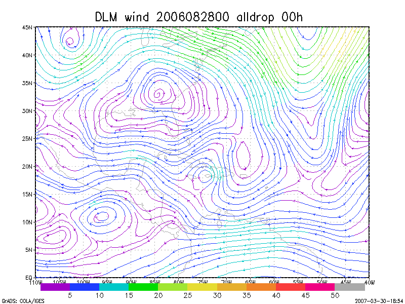
Figure 1. NCEP 850 - 200 hPa mean wind analysis for 28 August 2006 0000 UTC (Tropical Storm Ernesto).
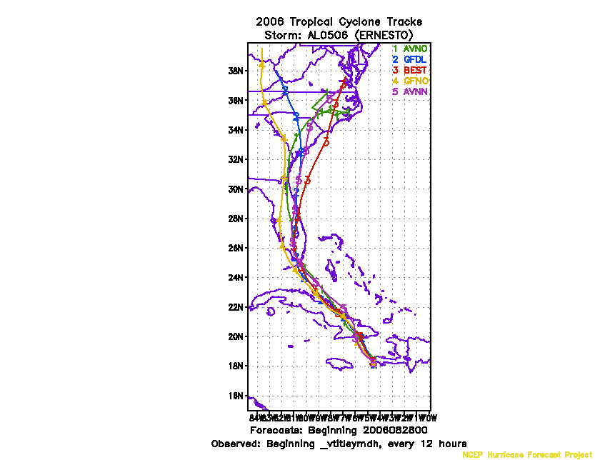
Figure 2. Track forecasts for the no dropwindsonde (NO or NN) and the all dropwindsonde (AL) runs for the AVN and GFDL models initialized on 28 August 2006 0000 UTC.
Figure 3. NCEP Global Ensemble Prediction System track forecasts for all cyclones in the Atlantic basin initialized from 26 August 2006 0600 UTC to 27 August 2006 0000 UTC, showing the tracks of Tropical Storm Ernesto.
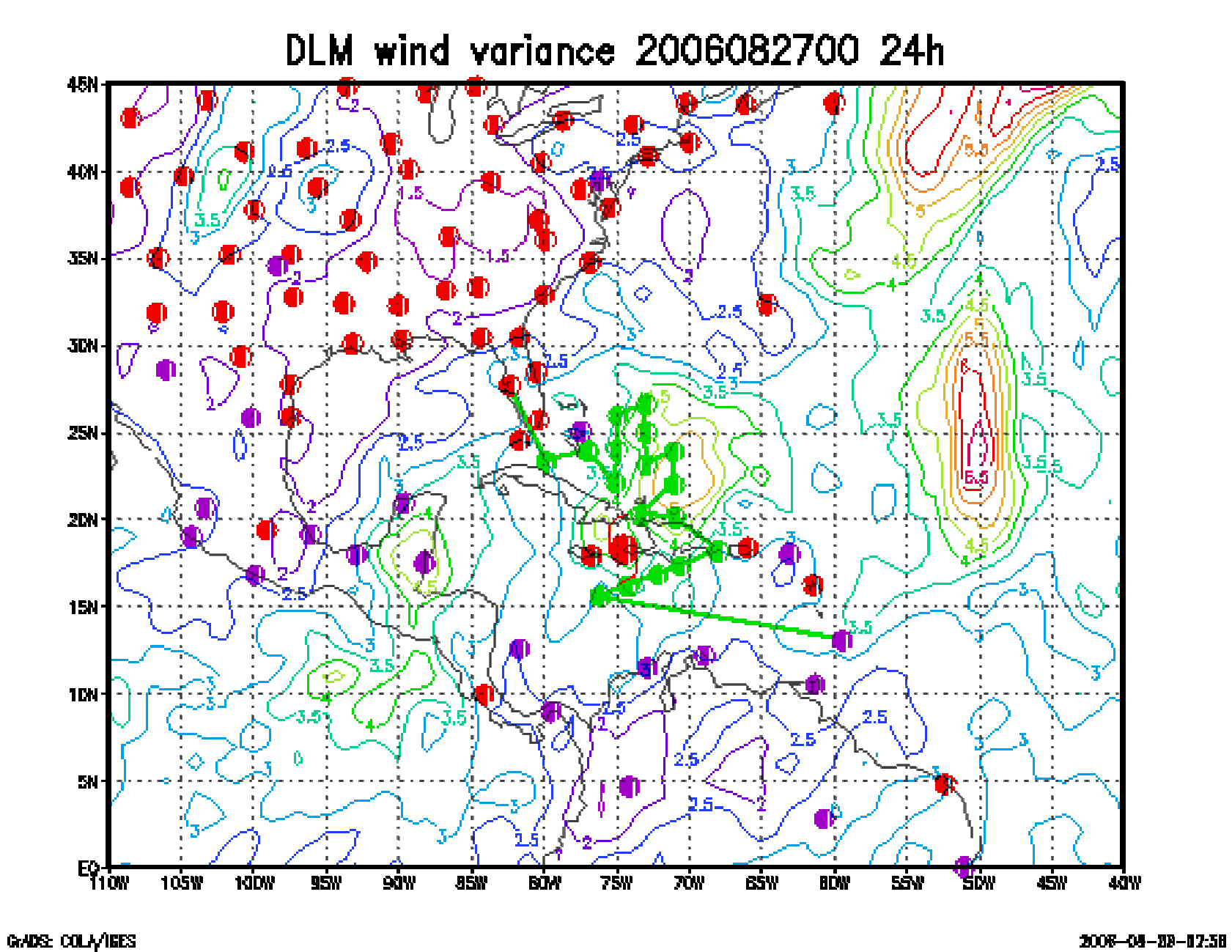
Figure 4. Ensemble perturbation variance at the nominal sampling time 28 August 2006 0000 UTC from the previous day NCEP ensemble forecast. The green circles represent the dropwindsonde locations.
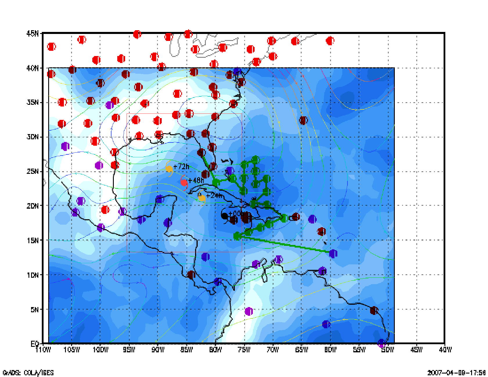
Figure 5. Variance explained within the verification region (large red circle) for observations taken at the sampling time 28 August 2006 0000 UTC from the Ensemble Transform Kalman Filter run from the previous day NCEP ensemble forecast. The green circles represent the dropwindsonde locations.
Figure 6. Adjoint-Derived Steering Sensitivity Vector for observations taken at the sampling time 28 August 2006 0000 UTC. The green circles represent the dropwindsonde locations. [not available]
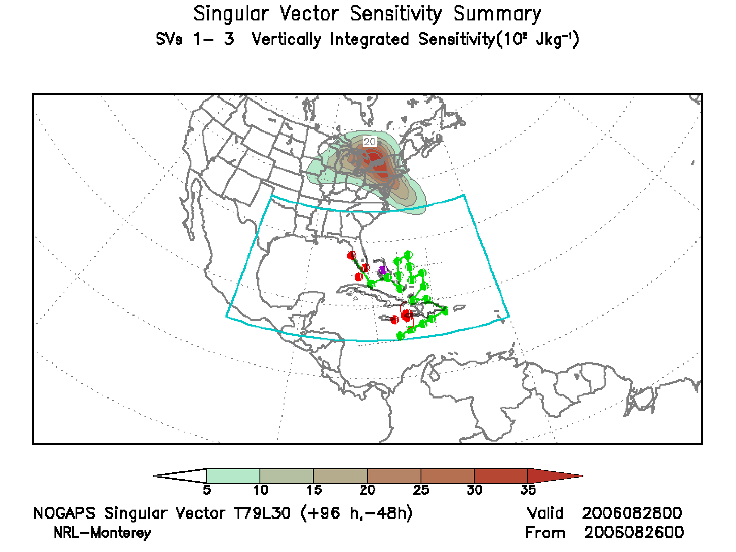
Figure 7. NOGAPS Singular Vector for observations taken at the sampling time 28 August 2006 0000 UTC. The green circles represent the dropwindsonde locations.
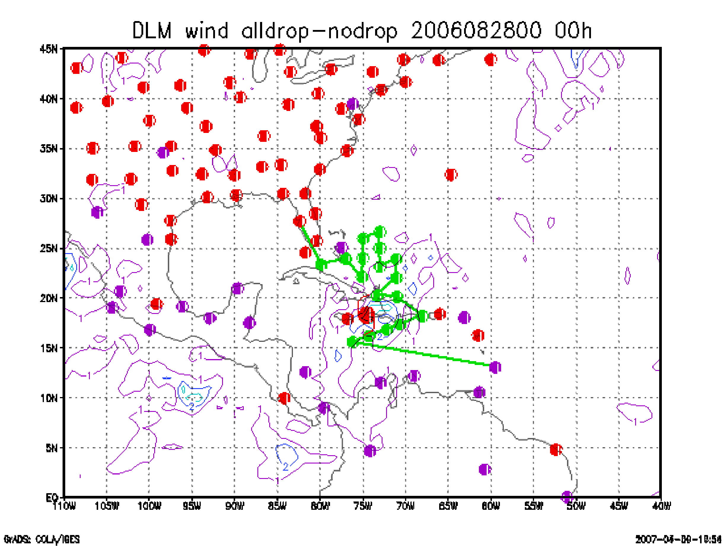
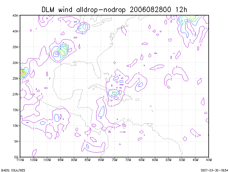
Figure 8. Initial condition differences in the 850 - 200 hPa mean wind between the no and all dropwindsonde cases for 28 August 2006 0000 UTC. The circles represent the dropwindsonde locations.