Effects of Synoptic Surveillance on model forecasts for
07 July 2005 0600 UTC
Dennis.
Quicktime movie of AVN DLM wind model
forecast
Quicktime movie of DLM wind data
increment
| TRACK (km) | ||||||||||||||||||||||||||||||||||||||||||||||||||||||||||||||||||||||||||||||||||||||||||||||||||||||||||||||||||||||||||||||||||||||||||||||||||||||||||||||||||||||||||
| MODEL | 12 h | 24 h | 36 h | 48 h | 60 h | 72 h | 84 h | 96 h | 108 h | 120 h
|
| AVNN | 94 | 105 | 188 | 129 | 83 | 104 | 187 | 282 | 271 | 379
| AVNO | 126 | 111 | 144 | 122 | 100 | 89 | 78 | 66 | 93 | 38
| %IMP | -34% | -6% | 23% | 5% | -20% | 14% | 58% | 77% | 66% | 90%
|
| GFNO | 35 | 148 | 153 | 151 | 169 | 200 | 211 | 171 | 167 | 145
| GFDL | 35 | 166 | 126 | 133 | 202 | 249 | 238 | 237 | 266 | 193
| %IMP | 0% | -12% | 18% | 12% | -20% | -25% | -13% | -39% | -59% | -33%
|
| INTENSITY (kt)
| MODEL | 12 h | 24 h | 36 h | 48 h | 60 h | 72 h | 84 h | 96 h | 108 h | 120 h
|
| AVNN | -65 | -73 | -81 | -36 | -54 | -87 | -72 | 8 | 0 | 1
| AVNO | -59 | -52 | -75 | -7 | -23 | -54 | -46 | -5 | -4 | 0
| %IMP | 9% | 29% | 7% | 81% | 57% | 38% | 36% | 38% | und% | 100%
|
| GFNO | -8 | -33 | -42 | 13 | 5 | -31 | -56 | -10 | 2 | 2
| GFDL | -9 | -28 | -59 | -2 | -6 | -38 | -62 | -5 | 1 | 4
| %imp | -13% | 15% | -40% | 85% | -20% | -23% | -11% | 50% | 50% | -100%
|
| | ||||||||||
| 08/0245 UTC 19.9N 77.6W Punta del Ingles, Cuba, 20.75 h into the forecast | ||||||||||||||||||||||||||||||||||||||||||||||||||||||||||||||||||||||||||||||||||||||||||||||||||||||||||||||||||||||||||||||||||||||||||
| MODEL | LAT | LON | TIME | ERROR | LOCATION
|
| AVNN | 19.89 | 77.15 | 16.0 | 47.0 | Near Bartolome Maso, Granma, Cuba
| AVNO | 19.91 | 76.66 | 14.0 | 98.2 | Near Bartolome Maso, Granma, Cuba
| %IMP | -42% | -33%
|
| GFNO | 19.90 | 77.12 | 16.5 | 50.1 | Near Bartolome Maso, Granma, Cuba
| GFDL | 19.89 | 76.75 | 16.0 | 88.8 | Near Bartolome Maso, Granma, Cuba
| %IMP | -12% | -77%
|
|
08/1845 UTC 22.1N 80.7W just west of Punta Mangles Altos, Cuba, 36.75 h into the forecast
| MODEL | LAT | LON | TIME | ERROR | LOCATION
|
| AVNN | 21.67 | 79.11 | 26.0 | 170.7 | Near Sancti Spiritus, Sancti Spiritus, Cuba
| AVNO | 21.51 | 78.67 | 25.5 | 219.4 | Ciego Corojo, Ciego de Avila, Cuba
| %IMP | -5% | -29%
|
| GFNO | 20.74 | 77.86 | 20.0 | 330.3 | Santa Cruz del Sur, Camaguey, Cuba
| GFDL | 20.56 | 77.24 | 18.5 | 396.9 | Near Jobabo, Las Tunas, Cuba
| %IMP | -9% | -20%
|
10/1930 UTC 30.4N 87.1W Santa Rosa Island, FL, 85.5 h into the forecast
| MODEL | LAT | LON | TIME | ERROR | LOCATION
|
| AVNN | 30.30 | 89.11 | 97.0 | 193.0 | Gulfport, MS
| AVNO | 30.39 | 86.72 | 83.0 | 36.4 | Fort Walton Beach, FL
| %IMP | 78% | 71%
|
| GFNO | 30.41 | 86.29 | 78.0 | 77.6 | Destin, FL
| GFDL | 29.72 | 85.07 | 74.0 | 209.3 | Apalachicola, FL
| %IMP | -53% | -170%
| | ||||||||||||||||||||||
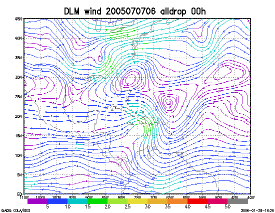
Figure 1. NCEP 850 - 200 hPa mean wind analysis for 07 July 2005 0600 UTC (Hurricane Dennis).
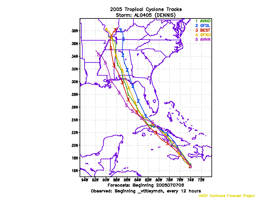
Figure 2. Track forecasts for the no dropwindsonde (NO or NN) and the all dropwindsonde (AL) runs for the AVN and GFDL models initialized on 07 July 2005 0600 UTC.
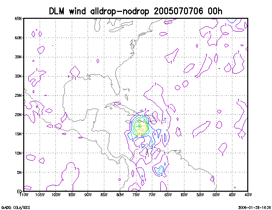
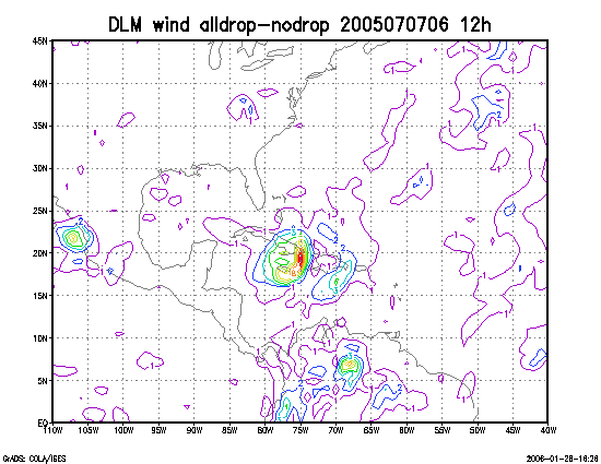
Figure 3. Initial condition differences in the 850 - 200 hPa mean wind between the no and all dropwindsonde cases for 07 July 2005 0600 UTC.