Effects of Synoptic Surveillance on model forecasts for
07 July 2005 0000 UTC
Dennis.
Quicktime movie of AVN DLM wind model
forecast
Quicktime movie of DLM wind data
increment
| TRACK (km) | ||||||||||||||||||||||||||||||||||||||||||||||||||||||||||||||||||||||||||||||||||||||||||||||||||||||||||||||||||||||||||||||||||||||||||||||||||||||||||||||||||||||||||
| MODEL | 12 h | 24 h | 36 h | 48 h | 60 h | 72 h | 84 h | 96 h | 108 h | 120 h
|
| AVNN | 49 | 98 | 153 | 76 | 111 | 165 | 271 | 372 | 359 | 337
| AVNO | 46 | 70 | 127 | 75 | 156 | 89 | 69 | 88 | 104 | 129
| %IMP | 6% | 29% | 17% | 1% | -41% | 46% | 75% | 76% | 71% | 62%
|
| GFNO | 77 | 100 | 144 | 135 | 127 | 147 | 189 | 135 | 145 | 136
| GFDL | 74 | 113 | 152 | 147 | 195 | 267 | 312 | 255 | 275 | 238
| %IMP | 4% | -13% | -6% | -9% | -54% | -82% | -65% | -89% | -90% | -75%
|
| INTENSITY (kt)
| MODEL | 12 h | 24 h | 36 h | 48 h | 60 h | 72 h | 84 h | 96 h | 108 h | 120 h
|
| AVNN | -58 | -81 | -84 | -63 | -41 | -75 | -78 | -3 | 13 | 4
| AVNO | -49 | -77 | -83 | -46 | -21 | -34 | -47 | 6 | -2 | -2
| %IMP | 16% | 5% | 1% | 27% | 49% | 55% | 40% | -100% | 85% | 50%
|
| GFNO | -10 | -17 | -6 | 6 | 30 | -4 | -28 | -6 | -0 | 3
| GFDL | -4 | -18 | -32 | 2 | 16 | -21 | -57 | -14 | -8 | 5
| %imp | 60% | -6% | -433% | 67% | 47% | -425% | -104% | -133% | und% | -67%
|
| | ||||||||||
| 08/0245 UTC 19.9N 77.6W Punta del Ingles, Cuba, 26.75 h into the forecast | ||||||||||||||||||||||||||||||||||||||||||||||||||||||||||||||||||||||||||||||||||||||||||||||||||||||||||||||||||||||||||||||||||||||||||
| MODEL | LAT | LON | TIME | ERROR | LOCATION
|
| AVNN | 19.92 | 77.19 | 22.5 | 42.9 | Near Bartolome Maso, Granma, Cuba
| AVNO | 19.91 | 77.19 | 23.5 | 42.8 | Near Bartolome Maso, Granma, Cuba
| %IMP | 24% | 0%
|
| GFNO | 19.82 | 77.79 | 23.5 | 21.8 | Near Niquero, Granma, Cuba
| GFDL | 19.88 | 77.07 | 21.5 | 55.4 | Near Bartolome Maso, Granma, Cuba
| %IMP | 62% | -154%
|
|
08/1845 UTC 22.1N 80.7W just west of Punta Mangles Altos, Cuba, 42.75 h into the forecast
| MODEL | LAT | LON | TIME | ERROR | LOCATION
|
| AVNN | 21.57 | 79.09 | 31.5 | 176.2 | Near Banao, Sancti Spiritus, Cuba
| AVNO | 22.14 | 80.46 | 38.0 | 25.1 | Cienfuegos, Cienfuegos, Cuba
| %IMP | 58% | 86%
|
| GFNO | 22.08 | 81.22 | 39.0 | 53.6 | Near Jaguey Grande, Matanzas, Cuba
| GFDL | 21.60 | 79.48 | 32.5 | 137.5 | Near Banao, Sancti Spiritus, Cuba
| %IMP | -173% | -157%
|
10/1930 UTC 30.4N 87.1W Santa Rosa Island, FL, 91.5 h into the forecast
| MODEL | LAT | LON | TIME | ERROR | LOCATION
|
| AVNN | 29.78 | 89.38 | 103.5 | 229.8 | St. Malo, LA
| AVNO | 30.22 | 87.95 | 93.0 | 83.9 | Gulf Shores, AL
| %IMP | 87% | 63%
|
| GFNO | 30.42 | 86.49 | 85.0 | 58.5 | Destin, FL
| GFDL | 29.68 | 85.34 | 77.0 | 187.2 | Port St. Joe, FL
| %IMP | -123% | -220%
| | ||||||||||||||||||||||
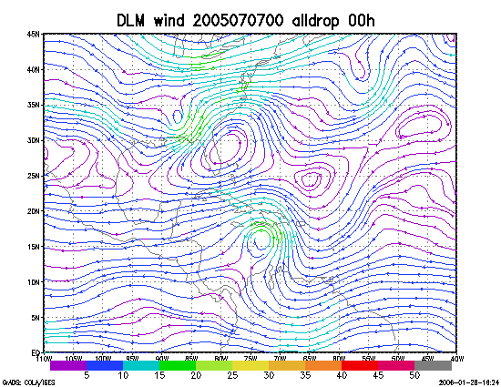
Figure 1. NCEP 850 - 200 hPa mean wind analysis for 07 July 2005 0000 UTC (Hurricane Dennis).
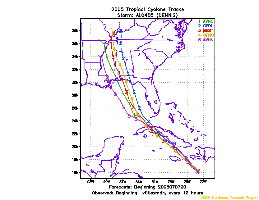
Figure 2. Track forecasts for the no dropwindsonde (NO or NN) and the all dropwindsonde (AL) runs for the AVN and GFDL models initialized on 07 July 2005 0000 UTC.
Figure 3. NCEP Global Ensemble Prediction System track forecasts for all cyclones in the Atlantic basin initialized from 05 July 2005 0600 UTC to 06 July 2005 0000 UTC, showing the tracks of Hurricane Dennis. [No ensemble tracks available]
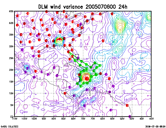
Figure 4. Ensemble perturbation variance at the nominal sampling time 07 July 2005 0000 UTC from the previous day NCEP ensemble forecast. The green circles represent the dropwindsonde locations.
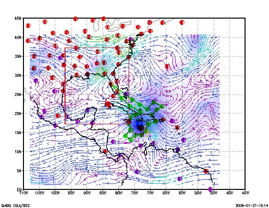
Figure 5. Variance explained within the verification region (large red circle) for observations taken at the sampling time 07 July 2005 0000 UTC from the Ensemble Transform Kalman Filter run from the previous day NCEP ensemble forecast. The green circles represent the dropwindsonde locations.
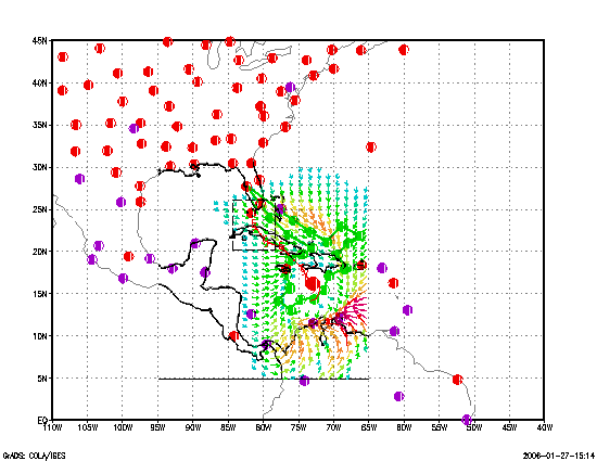
Figure 6. Adjoint-Derived Steering Sensitivity Vector for observations taken at the sampling time 07 July 2005 0000 UTC. The green circles represent the dropwindsonde locations.
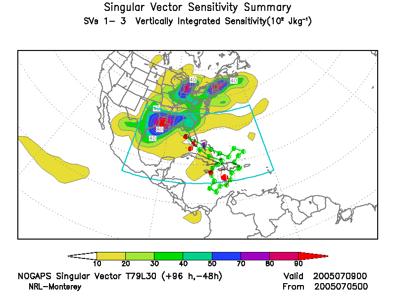
Figure 7. NOGAPS Singular Vector for observations taken at the sampling time 07 July 2005 0000 UTC. The green circles represent the dropwindsonde locations.
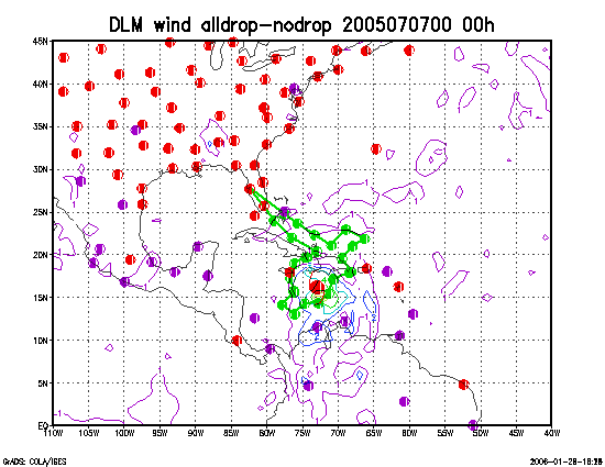
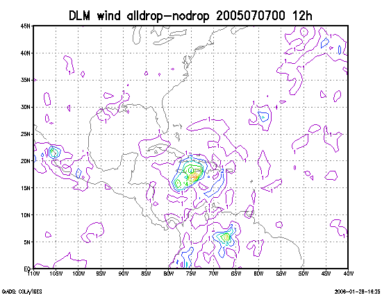
Figure 8. Initial condition differences in the 850 - 200 hPa mean wind between the no and all dropwindsonde cases for 07 July 2005 0000 UTC. The circles represent the dropwindsonde locations.