Effects of Synoptic Surveillance on model forecasts for
22 August 2000 0000 UTC
DEBBY.
QuickTime movie of DLM wind model forecasts
QuickTime movie of DLM wind data increments
| TRACK (km) | ||||||||||||||||||||||||||||||||||||||||||||||||||||||||||||||||||||||||||||||||||||||||||||||||||||||||||||||||||||||||||||||||||||||||||||||||||||||||||||||||||||||||||||
| MODEL | 12 h | 24 h | 36 h | 48 h | 60 h | 72 h | 84 h | 96 h | 108 h | 120 h
|
| AVNN | 92. | 133. | 128. | 42. | 241.
| AVAL | 77. | 183. | 300. | 252. | 216.
| %IMP | 16% | -38% | -134% | -500% | 11%
|
| GFNO | 100. | 100. | 105. | 312. | 512.
| GFAL | 164. | 300. | 370. | 306. | 183.
| %IMP | -64% | -200% | -252% | 2% | 64% |
|
| VBNO | 215. | 309. | 356. | 483. | 643.
| VBAL | 215. | 307. | 341. | 447. | 586.
| %IMP | 0% | 1% | 4% | 7% | 9% |
| INTENSITY (kt)
| MODEL | 12 h | 24 h | 36 h | 48 h | 60 h | 72 h | 84 h | 96 h | 108 h | 120 h
|
| AVNN | -31. | -32. | -30. | -8. | -1.
| AVAL | -28. | -30. | -36. | -17. | -12.
| %IMP | 10% | 6% | -20% | -113%-1100%
|
| GFNO | -3. | 19. | 34. | 61. | 71.
| GFAL | -13. | -14. | 3. | 25. | 43.
| %IMP | -333% | 26% | 91% | 59% | 39% |
|
| SHNO | -6. | -11. | -11. | 9. | 19.
| SHAL | -6. | -13. | -14. | 5. | 14.
| %IMP | 0% | -18% | -27% | 44% | 26% |
|
| DSNO | -6. | -17. | -24. | -3. | 7.
| DSAL | -6. | -18. | -25. | -5. | 5.
| %IMP | 0% | -6% | -4% | -67% | 29%
| | ||||||||||||||
22/0600 UTC 17.5N 61.7W nearBarbuda 6 h into the forecast
| MODEL | LAT | LON | TIME | ERROR | LOCATION
|
| AVNN | 17.04 | 61.88 | 4.5 | 54.6 | Johnsons Point, Antigua
| AVAL | 17.05 | 61.87 | 5.0 | 53.1 | Urlins, Antigua
| %IMP | 33% | 3% |
|
| GFNO | 16.48 | 61.44 | 3.5 | 116.6 | Campeche, Guadeloupe
| GFAL | 16.57 | 61.50 | 3.5 | 105.5 | Pointe de la Grande Vigie, Guadeloupe
| %IMP | 0% | 10%
|
| VBNO | 16.62 | 61.41 | 8.5 | 102.5 | Pointe de la Grande Vigie, Guadeloupe
| VBAL | 16.50 | 61.43 | 8.0 | 114.7 | Pointe de la Grande Vigie, Guadeloupe
| %IMP | 20% | -12%
|
| 22/0915 UTC 17.9N 62.8W near St.-Barthelemy 8.25 h into the forecast
| MODEL | LAT | LON | TIME | ERROR | LOCATION
|
| AVNN | 17.27 | 62.73 | 7.0 | 70.4 | Basseterre, St. Kitts
| AVAL | 17.38 | 62.83 | 8.0 | 57.9 | Sandy Point Town, St. Kitts
| %IMP | 80% | 18%
|
| GFNO | 16.66 | 62.15 | 6.0 | 154.1 | Plymouth, Montserrat
| GFAL | 16.68 | 62.19 | 5.5 | 150.2 | Plymouth, Montserrat
| %IMP | -22% | 3%
|
| VBNO | 16.86 | 62.18 | 13.0 | 132.9 | Plymouth, Montserrat
| VBAL | 16.73 | 62.19 | 12.5 | 145.2 | Plymouth, Montserrat
| %IMP | 11% | -9%
|
|
| 22/1500 UTC 18.5N 64.4W near Virgin Gorda 15 h into the forecast
| MODEL | LAT | LON | TIME | ERROR | LOCATION
|
|
| AVNN | 17.70 | 64.73 | 14.0 | 95.5 | Vagthus Point, St. Croix, U.S. Virgin Islands
| AVAL | 17.79 | 64.57 | 13.5 | 80.9 | East Point, St. Croix, U.S. Virgin Islands
| %IMP | -50% | 15%
|
| GFNO | 17.73 | 64.65 | 17.0 | 89.5 | Grass Point, St. Croix, U.S. Virgin Islands
| GFAL | 16.92 | 64.90 | 13.5 | 183.3 | Near St. Croix, U.S. Virgin Islands
| %IMP | 25% | -105%
|
| VBNO | 17.77 | 64.80 | 26.5 | 91.4 | Davis Beach, St. Croix, U.S. Virgin Islands
| VBAL | 17.65 | 64.94 | 26.5 | 110.3 | Sandy Piont, St. Croix, U.S. Virgin Islands
| %IMP | 0% | -21%
|
| | ||||||||||||||||||||||||||||||||||||||
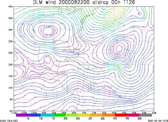
Figure 1. NCEP 850 - 200 hPa mean wind analysis for 22 August 2000 0000 UTC (Hurricane Debby).
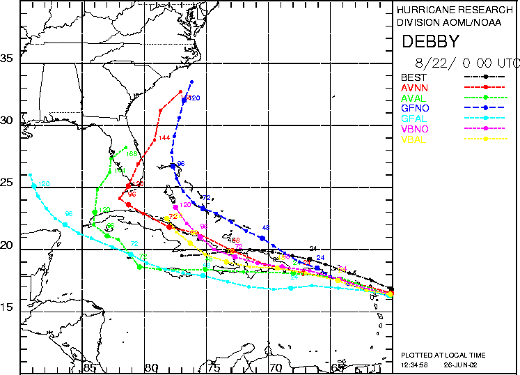
Figure 2. Track forecasts for the no dropwindsonde (NO or NN) and the all dropwindsonde (AL) runs for the AVN, GFDL, and VBAR models initialized on 22 August 2000 0000 UTC. The best track is shown in black.
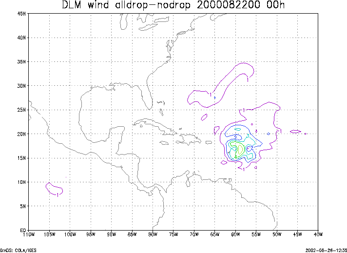
Figure 3. Ensemble perturbation variance at the nominal sampling time 22 August 2000 0000 UTC from the previous day NCEP ensemble forecast. The green circles represent the dropwindsonde locations.
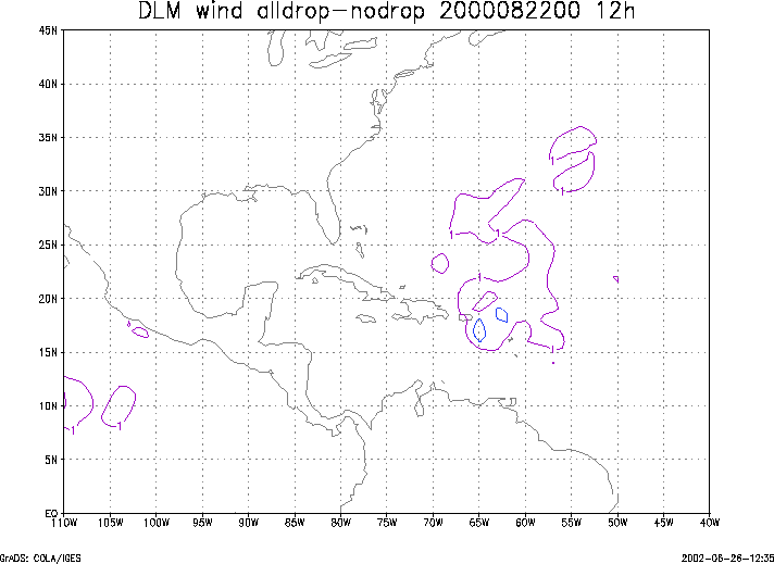
Figure 4. Initial condition differences in the 850 - 200 hPa mean wind between the no and all dropwindsonde cases for 22 August 2000 0000 UTC. The green circles represent the dropwindsonde locations.
