Effects of Synoptic Surveillance on model forecasts for
21 August 2000 0000 UTC
DEBBY.
QuickTime movie of DLM wind model forecasts
QuickTime movie of DLM wind data increments
| TRACK (km) | |||||||||||||||||||||||||||||||||||||||||||||||||||||||||||||||||||||||||||||||||||||||||||||||||||||||||||||||||||||||||||||||||||||||||||||||||||||||||||||||||||||||||||||||||||||||||||||||||||||||||
| MODEL | 12 h | 24 h | 36 h | 48 h | 60 h | 72 h | 84 h | 96 h | 108 h | 120 h
|
| AVNN | 133. | 112. | 125. | 146. | 248. | 196.
| AVAL | 109. | 98. | 195. | 207. | 252. | 206.
| %IMP | 18% | 13% | -56% | -42% | -2% | -5%
|
| GFNO | 119. | 129. | 67. | 146. | 185. | 77. | 252.
| GFAL | 63. | 194. | 237. | 258. | 283. | 453. | 739.
| %IMP | 47% | -50% | -254% | -77% | -53% | -188% | -193%
|
| VBNO | 251. | 345. | 392. | 455. | 523. | 681. | 868.
| VBAL | 218. | 301. | 321. | 378. | 428. | 574. | 759.
| %IMP | 13% | 13% | 18% | 17% | 18% | 16% | 13%
| INTENSITY (kt)
| MODEL | 12 h | 24 h | 36 h | 48 h | 60 h | 72 h | 84 h | 96 h | 108 h | 120 h
|
| AVNN | -41. | -38. | -36. | -39. | -43. | -26.
| AVAL | -30. | -31. | -31. | -35. | -34. | -22.
| %IMP | 27% | 18% | 14% | 10% | 21% | 15%
|
| GFNO | -25. | -13. | -12. | -17. | -18. | 7. | 31.
| GFAL | -28. | 1. | 25. | 40. | 47. | 72. | 70.
| %IMP | -12% | 92% | -108% | -135% | -161% | -929% | -126%
|
| SHNO | -21. | -9. | 3. | 9. | 19. | 41. | 53.
| SHAL | -22. | -10. | 0. | 4. | 12. | 32. | 43.
| %IMP | -5% | -11% | 100% | 56% | 37% | 22% | 19%
|
| DSNO | -21. | -9. | 3. | 9. | 19. | 41. | 53.
| DSAL | -22. | -10. | 0. | 4. | 12. | 32. | 43.
| %IMP | -5% | -11% | 100% | 56% | 37% | 22% | 19%
| | ||||||||||
22/0600 UTC 17.5N 61.7W near Barbuda 30 h into the forecast
| MODEL | LAT | LON | TIME | ERROR | LOCATION
|
| AVNN | 18.16 | 61.71 | 28.0 | 73.3 | Near Barbuda
| AVAL | 17.11 | 61.74 | 26.0 | 43.5 | Parham, Antigua
| %IMP | -100% | 41% |
|
| GFNO | 18.16 | 61.72 | 29.5 | 73.4 | Near Barbuda
| GFAL | 17.88 | 61.82 | 38.0 | 44.1 | Near Barbuda
| %IMP | -1500% | 40%
|
| VBNO | 19.45 | 61.18 | 42.0 | 223.5 | Near Barbuda
| VBAL | 18.88 | 61.40 | 40.0 | 156.6 | Near Barbuda
| %IMP | 17% | 30%
|
|
| 22/0915 UTC 17.9N 62.8W near St.-Barthelemy 33.25 h into the forecast
| MODEL | LAT | LON | TIME | ERROR | LOCATION
|
| AVNN | 18.46 | 62.99 | 31.5 | 65.4 | Near Anguilla
| AVAL | 17.27 | 62.69 | 28.5 | 71.0 | Frigate Bay, St. Kitts
| %IMP | -171% | -9%
|
| GFNO | 18.24 | 63.01 | 33.0 | 43.8 | The Valley, Anguilla
| GFAL | 18.24 | 62.95 | 42.5 | 41.0 | The Valley, Anguilla
| %IMP | -3600% | 6%
|
| VBNO | 19.85 | 62.60 | 49.0 | 217.7 | Near Anguilla
| VBAL | 19.29 | 62.68 | 46.0 | 154.9 | Near Anguilla
| %IMP | 19% | 29%
|
|
| 22/1500 UTC 18.5N 64.4W near Virgin Gorda 39 h into the forecast
| MODEL | LAT | LON | TIME | ERROR | LOCATION
|
|
| AVNN | 18.68 | 64.34 | 35.5 | 21.0 | Anegada
| AVAL | 17.63 | 64.84 | 34.5 | 107.2 | Long Point, St. Croix, U.S. Virgin Islands
| %IMP | -29% | -410%
|
| GFNO | 18.35 | 64.97 | 38.5 | 62.3 | Altona, St. Thomas, British Virgin Islands
| GFAL | 18.70 | 64.30 | 48.0 | 24.6 | Anegada
| %IMP | -1700% | 61%
|
| VBNO | 20.10 | 64.05 | 56.5 | 181.5 | Near Anegada
| VBAL | 19.60 | 64.16 | 53.0 | 124.8 | Near Anegada
| %IMP | 20% | 31%
| | |||||||||||||||||||||||||||||||||||||||||||
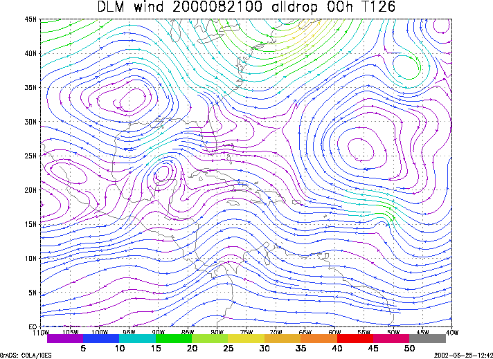
Figure 1.
NCEP 850 - 200 hPa mean wind analysis for 21 August 2000 0000 UTC
(Tropical Storm Debby).
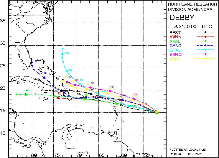
Figure 2. Track forecasts for the no dropwindsonde (NO or NN) and the all dropwindsonde (AL) runs for the AVN, GFDL, and VBAR models initialized on 21 August 2000 0000 UTC. The best track is shown in black.
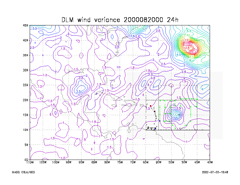
Figure 3. Ensemble perturbation variance at the nominal sampling time 21 August 2000 0000 UTC from the previous day NCEP ensemble forecast. The green circles represent the dropwindsonde locations.
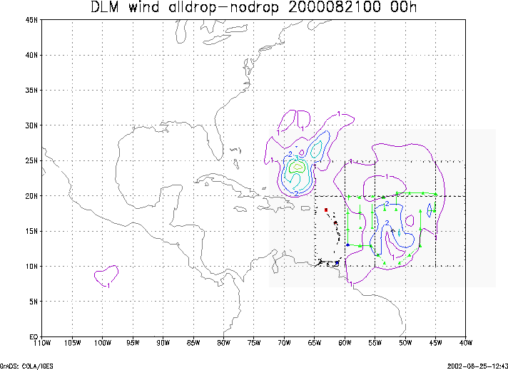
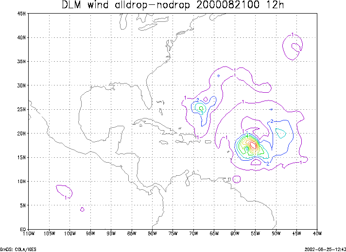
Figure 4.
Initial condition differences in the 850 - 200 hPa mean wind
between the no and all dropwindsonde cases
for 21 August 2000 0000 UTC.
The green circles represent the dropwindsonde locations.