Effects of Synoptic Surveillance on model forecasts for
12 July 2003 1800 UTC
Claudette.
Quicktime movie of GFS DLM wind model
forecast
Quicktime movie of DLM wind data
increment
| TRACK (km) | |||||||||||||||||||||||||||||||||||||||||||||||||||||||||||||||||||||||||||||||||||||||||||||||||||||||||||||||||||||||||||||||||||||||||||||||||||||||||||||||||||||||||||||||||||||||||||||||||||||||||||||||||||||
| MODEL | 12 h | 24 h | 36 h | 48 h | 60 h | 72 h | 84 h | 96 h | 108 h | 120 h
|
| GFSN | 30 | 101 | 243 | 338 | 359 | 349 | 364 | 512
| GFSO | 15 | 74 | 220 | 336 | 365 | 411 | 468 | 694
| %IMP | 50% | 27% | 9% | 1% | -1% | -18% | -29% | -36%
|
| GFNO | 46 | 121 | 251 | 355 | 371 | 337 | 276 | 312
| GFDL | 32 | 120 | 215 | 335 | 352 | 324 | 274 | 301
| %IMP | 30% | 1% | 14% | 6% | 5% | 4% | 1% | 4%
|
| GFSN | -16 | -22 | -25 | -35 | -41 | -44 | -22 | -24
| GFSO | -5 | -12 | -19 | -30 | -36 | -42 | -16 | -16
| %IMP | 69% | 45% | 24% | 14% | 12% | 5% | 27% | 33% |
| INTENSITY (kt)
| MODEL | 12 h | 24 h | 36 h | 48 h | 60 h | 72 h | 84 h | 96 h | 108 h | 120 h
|
| GFNO | 7 | 6 | 1 | -12 | -12 | -32 | -2 | 3
| GFDL | 13 | 2 | 12 | 8 | 7 | -27 | 7 | 3
| %IMP | -86% | 67% | -1100% | 33% | 42% | 16% | -250% | 100%
|
| SHNO | No forecast available
| SHIP | No forecast available
| %IMP | | | | | | | | | |
|
| DSNO | No forecast available
| DSHP | No forecast available
| %IMP | | | | | | | | | |
| | ||||||||||||||||||||||||||||||||||||||||||||||
| 15/1530 UTC 28.3N 96.2W Matagorda Island, TX 69.5 h into the forecast | |||||||||||||||||||||||||||||||||||||||||
| MODEL | LAT | LON | TIME | ERROR | LOCATION
|
| GFSN | 25.47 | 97.27 | 68.0 | 331.8 | El Salado, Tamaulipas, Mexico
| GFSO | 24.59 | 97.63 | 84.5 | 436.0 | Puerto Rico, Tamaulipas, Mexico
| %IMP | -900% | -31%
|
| GFNO | 25.86 | 97.18 | 56.5 | 378.2 | San Vicente, Tamaulipas, Mexico
| GFDL | 26.16 | 97.17 | 56.5 | 256. | South Padre Island, TX
| %IMP | 0% | 32%
| | ||||
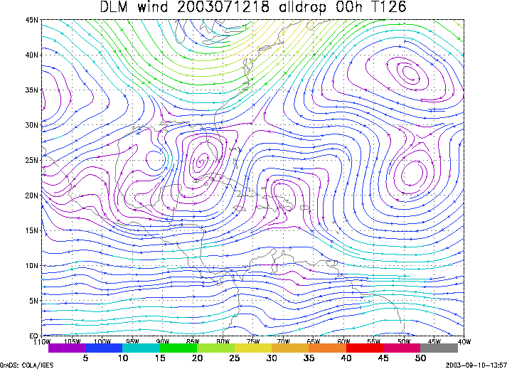
Figure 1. NCEP 850 - 200 hPa mean wind analysis for 12 July 2003 1800 UTC (Tropical Storm Claudette).
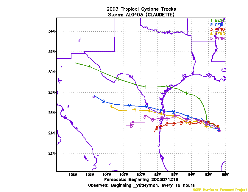
Figure 2. Track forecasts for the no dropwindsonde (NO or NN) and the all dropwindsonde (AL) runs for the GFS and GFDL models initialized on 12 July 2003 1800 UTC.
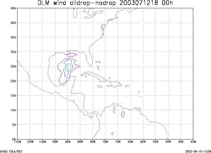
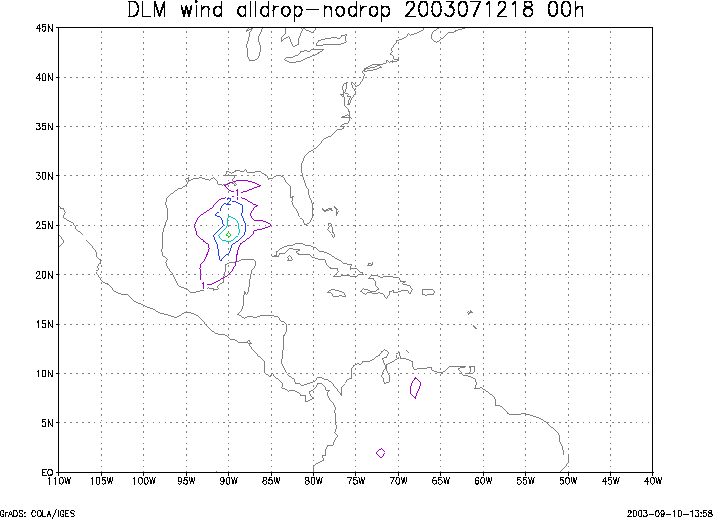
Figure 3. Initial condition differences in the 850 - 200 hPa mean wind between the no and all dropwindsonde cases for 12 July 2003 1800 UTC.