Effects of Synoptic Surveillance on model forecasts for
12 August 2004 0000 UTC
Charley.
Quicktime movie of AVN DLM wind model
forecast
Quicktime movie of DLM wind data
increment
| TRACK (km) | ||||||||||||||||||||||||||||||||||||||||||||||||||||||||||||||||||||||||||||||||||||||||||||||||||||||||||||||||||||||||||||||||||||
| MODEL | 12 h | 24 h | 36 h | 48 h | 60 h | 72 h | 84 h | 96 h | 108 h | 120 h
|
| AVNN | 69 | 53 | 55 | 157 | 209 | 258 | 212
| AVNO | 33 | 38 | 46 | 129 | 179 | 231 | 252
| %IMP | 52% | 28% | 16% | 18% | 14% | 10% | -19%
|
| GFNO | 44 | 103 | 159 | 303 | 492 | 726 | 925
| GFDL | 33 | 112 | 190 | 357 | 588 | 840 | 1062
| %IMP | 25% | -9% | -19% | -18% | -20% | -16% | -15%
| INTENSITY (kt)
| MODEL | 12 h | 24 h | 36 h | 48 h | 60 h | 72 h | 84 h | 96 h | 108 h | 120 h
|
| AVNN | -53 | -61 | -60 | -55 | -28 | -6 | -9
| AVNO | -48 | -55 | -56 | -46 | -12 | -10 | -6
| %IMP | 9% | 10% | 7% | 16% | 51% | -67% | 33%
|
| GFNO | 8 | 15 | 10 | 37 | 48 | 20 | 13
| GFDL | 19 | 4 | 12 | 42 | 47 | 20 | 40
| %IMP | -138% | 73% | -20% | -14% | 2% | 0% | -208%
| | ||||||||||
| 13/0430 UTC 22.7N 82.6W Near Playa del Cajio, Cuba 28.5 h into the forecast | ||||||||||||||||||||||||||||||||||||||||||||||||||||||||||||||||||||||||||||||||||||||||||||||||||||||||||||||||||||||||||||||||||||||||||||||||||||||||||||||||||||||||||||||||||||||||||||||||||||||||||||||||||||||||||||||
| MODEL | LAT | LON | TIME | ERROR | LOCATION
|
| AVNN | 22.50 | 83.05 | 29.5 | 51.2 | Los Palacios, Pinar del Rio, Cuba
| AVNO | 22.53 | 82.95 | 29.0 | 40.6 | San Cristobal, Pinar del Rio, Cuba
| %IMP | 50% | 21%
|
| GFNO | 22.25 | 83.56 | 31.0 | 110.5 | Pinar del Rio, Pinar del Rio, Cuba
| GFDL | 22.21 | 83.58 | 32.5 | 114.4 | San Juan y Martinez, Pinal del Rio, Cuba
| %IMP | -60% | -4%
|
|
13/1945 UTC 26.6N 82.2W Near Cayo Costa, FL 43.75 h into the forecast
| MODEL | LAT | LON | TIME | ERROR | LOCATION
|
| AVNN | 29.21 | 82.96 | 49.5 | 299.4 | Cedar Key, FL
| AVNO | 27.93 | 82.90 | 48.0 | 163.1 | Clearwater Beach, FL
| %IMP | 26% | 46%
|
| GFNO | 29.57 | 83.43 | 61.0 | 351.3 | Steinhatchee, FL
| GFDL | 29.98 | 83.78 | 65.0 | 406.1 | Perry, FL
| %IMP | -23% | -16%
|
13/2045 UTC 26.9N 82.1W Near Punta Gorda, FL 44.75 h into the forecast
| MODEL | LAT | LON | TIME | ERROR | LOCATION
|
| AVNN | 29.21 | 82.96 | 49.5 | 270.1 | Cedar Key, FL
| AVNO | 28.95 | 82.70 | 51.0 | 235.2 | Port Inglis, FL
| %IMP | -32% | 13%
|
| GFNO | 29.57 | 83.43 | 61.0 | 323.9 | Steinhatchee, FL
| GFDL | 29.98 | 83.78 | 65.0 | 379.5 | Perry, FL
| %IMP | -25% | -17%
|
|
14/1400 UTC 33.0N 79.4W Near Cape Romain, SC 62.0 h into the forecast
| MODEL | LAT | LON | TIME | ERROR | LOCATION
|
| AVNN | No landfall forecast
| AVNO | No landfall forecast
| %IMP
|
| GFNO | No landfall forecast
| GFDL | No landfall forecast
| %IMP
|
|
14/1600 UTC 33.8N 78.7W Near North Myrtle Beach, SC 64.0 h into the forecast
| MODEL | LAT | LON | TIME | ERROR | LOCATION
|
| AVNN | No landfall forecast |
| AVNO | No landfall forecast
| %IMP
|
| GFNO | No landfall forecast
| GFDL | No landfall forecast
| %IMP
|
| | ||||||||||||||||||||||||||||||||||||||||||||||||||||||||||||||||
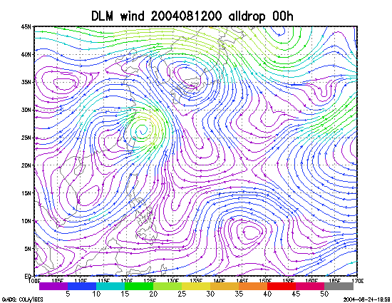
Figure 1. NCEP 850 - 200 hPa mean wind analysis for 12 August 2004 0000 UTC (Hurricane Charley).
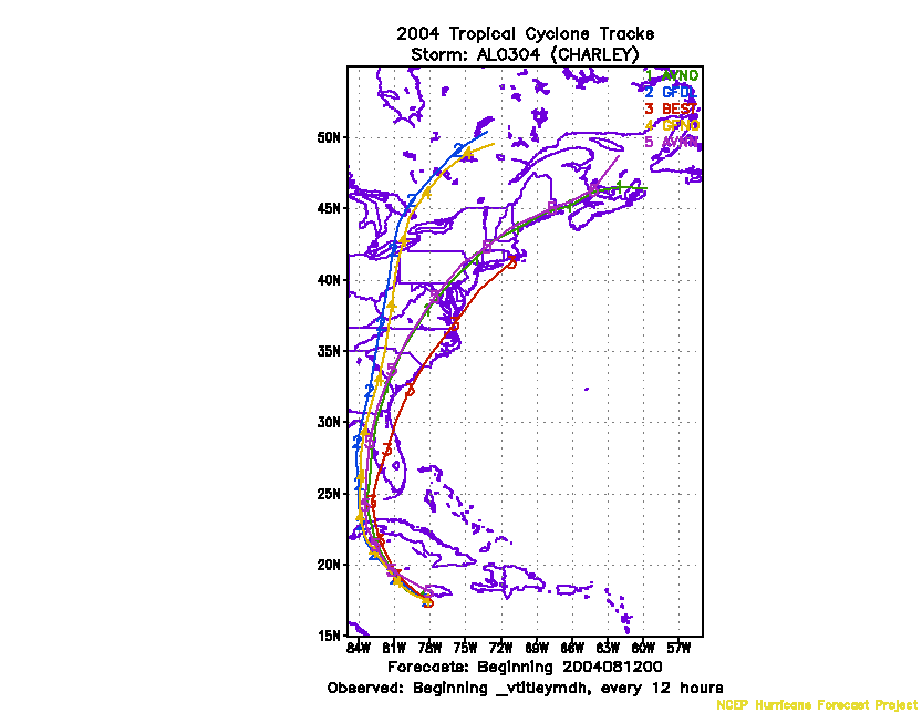
Figure 2. Track forecasts for the no dropwindsonde (NO or NN) and the all dropwindsonde (AL) runs for the AVN and GFDL models initialized on 12 August 2004 0000 UTC.
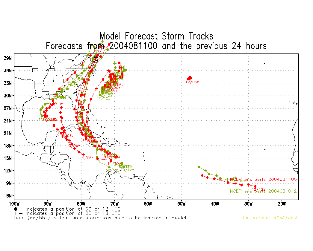
Figure 3. NCEP Global Ensemble Predction System track forecasts for all cyclones in the Atlantic basin initialized from 10 August 2004 0600 UTC to 11 August 2004 0000 UTC, showing the tracks of Hurricane Charley.
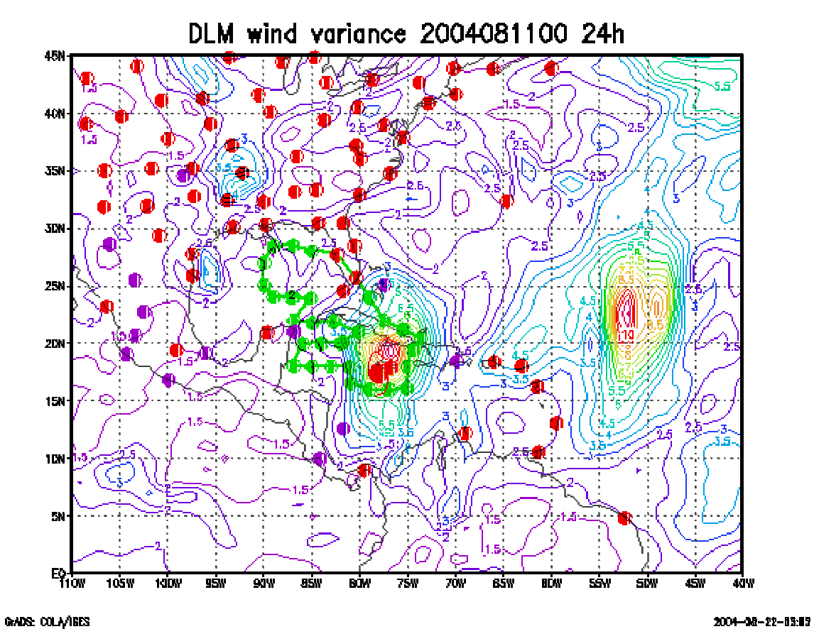
Figure 4. Ensemble perturbation variance at the nominal sampling time 12 August 2004 0000 UTC from the previous day NCEP ensemble forecast. The green circles represent the dropwindsonde locations.
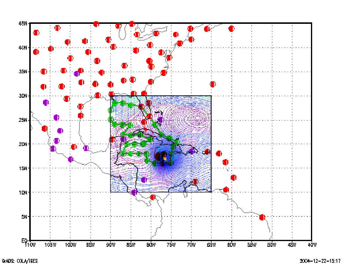
Figure 5. Variance explained within the verification region (large red circle) for observations taken at the sampling time 12 August 2004 0000 UTC from the Ensemble Transform Kalman Filter run from the previous day NCEP ensemble forecast. The green circles represent the dropwindsonde locations.
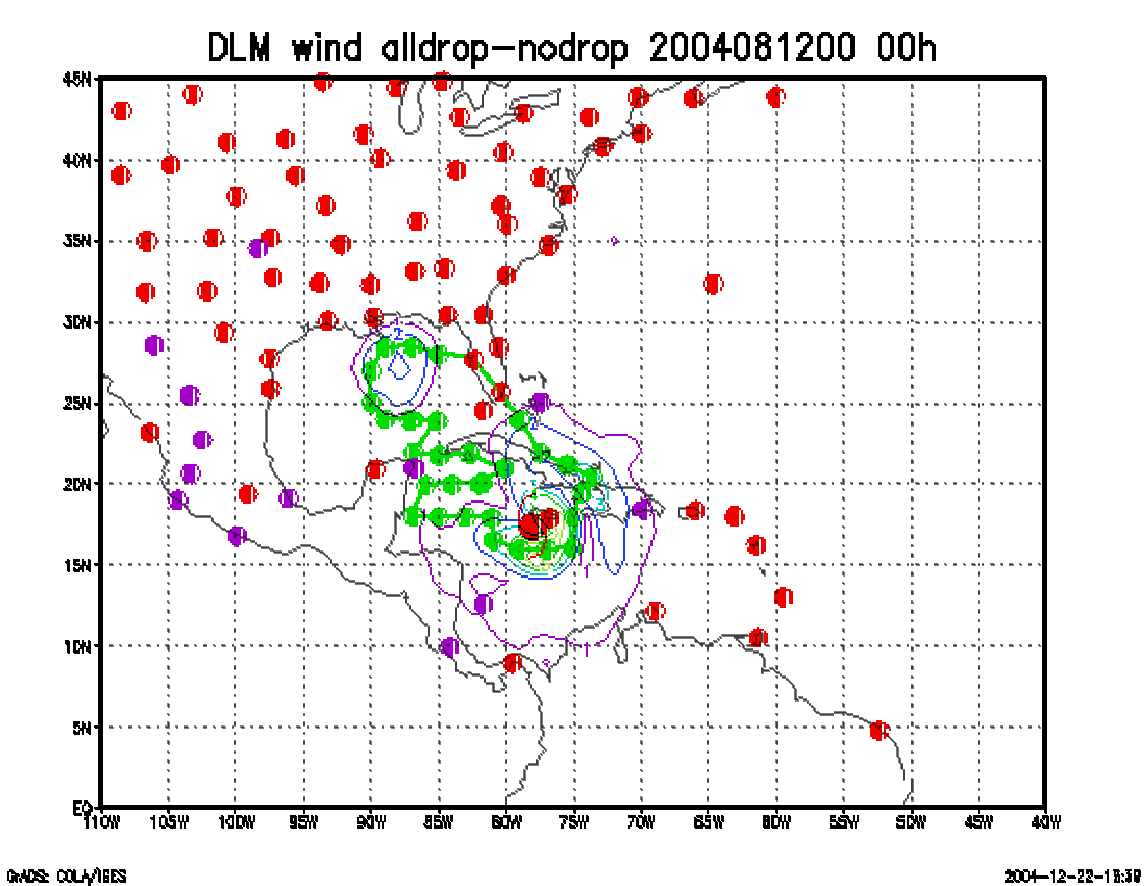
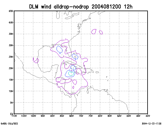
Figure 6. Initial condition differences in the 850 - 200 hPa mean wind between the no and all dropwindsonde cases for 12 August 2004 0000 UTC. The circles represent the dropwindsonde locations.