Effects of Synoptic Surveillance on model forecasts for
11 August 2004 0600 UTC
Bonnie.
Quicktime movie of AVN DLM wind model
forecast
Quicktime movie of DLM wind data
increment
| TRACK (km) | ||||||||||||||||||||||||||||||||||||||||||||||||||||||||||||||||||||||||||||||||||||||||||||||||||||||||||||||||||||||||||||||||||
| MODEL | 12 h | 24 h | 36 h | 48 h | 60 h | 72 h | 84 h | 96 h | 108 h | 120 h
|
| AVNN | 123 | 293 | 339 | 533 | 556 |
| AVNO | 179 | 219 | 232 | 378 | 434 | | |
| %IMP | -46% | 25% | 32% | 29% | 22% | | |
|
| GFNO | 59 | 111 | 160 | 234 | 424 |
| GFDL | 151 | 198 | 235 | 280 | 429 |
| %IMP | -156% | -78% | -47% | -20% | -1% |
| INTENSITY (kt)
| MODEL | 12 h | 24 h | 36 h | 48 h | 60 h | 72 h | 84 h | 96 h | 108 h | 120 h
|
| AVNN | -40 | -23 | -19 | -5 | -2 | | |
| AVNO | -33 | -21 | -13 | -4 | 2 | | |
| %IMP | 17% | 9% | 32% | 20% | 0% | | |
|
| GFNO | -5 | 29 | 15 | 16 | 16 |
| GFDL | -8 | 8 | 5 | 10 | 12 |
| %IMP | -60% | 72% | 67% | 37% | 25% |
| | ||||||||||
| 12/1400 UTC 29.6N 85.1W St. Vincent/St. George Is., FL 32.0 h into the forecast | |||||||||||||||||||||||||||||||||||||||||
| MODEL | LAT | LON | TIME | ERROR | LOCATION
|
| AVNN | 30.30 | 87.60 | 24.0 | 252.9 | Gulf Shores, FL
| AVNO | 30.45 | 86.53 | 27.5 | 166.9 | Fort Walton Beach, FL
| %IMP | 44% | 34%
|
| GFNO | 30.22 | 85.91 | 31.0 | 104.1 | Laguna Beach, FL
| GFDL | 30.22 | 85.96 | 28.5 | 107.7 | Laguna Beach, FL
| %IMP | -250% | -3%
| | ||||
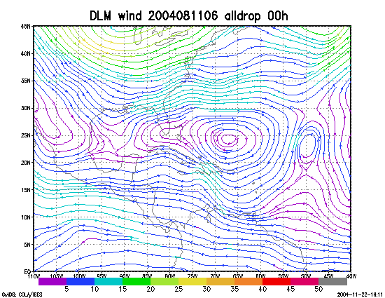
Figure 1. NCEP 850 - 200 hPa mean wind analysis for 11 August 2004 0600 UTC (Tropical Storm Bonnie).
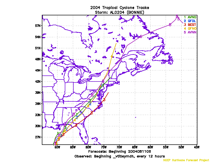
Figure 2. Track forecasts for the no dropwindsonde (NO or NN) and the all dropwindsonde (AL) runs for the AVN and GFDL models initialized on 11 August 2004 0600 UTC.
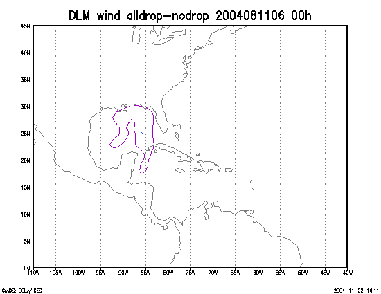
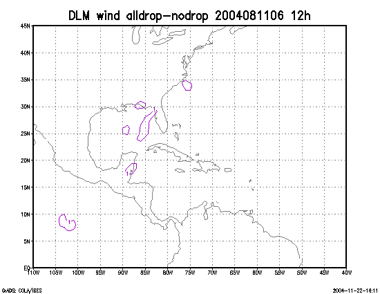
Figure 3. Initial condition differences in the 850 - 200 hPa mean wind between the no and all dropwindsonde cases for 11 August 2004 0600 UTC.