Effects of Synoptic Surveillance on model forecasts for
10 June 2005 1200 UTC
Arlene.
Quicktime movie of AVN DLM wind model
forecast
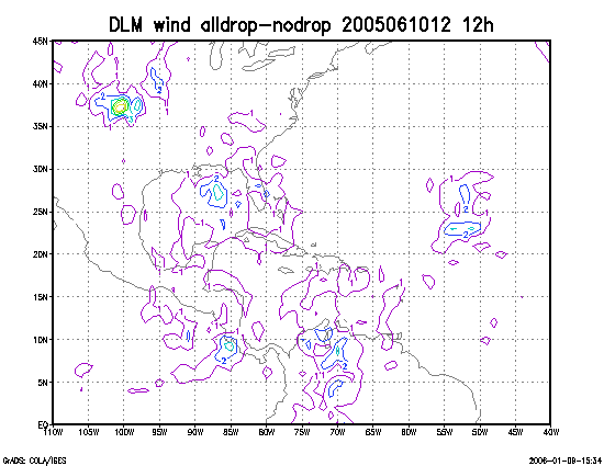
Quicktime movie of DLM wind data increment
| TRACK (km) | ||||||||||||||||||||||||||||||||||||||||||||||||||||||||||||||||||||||||||||||||||||||||||||||||||||||||||||||||||||||||||||||||||||||||||||||||||||||||||||||||||||||||
| MODEL | 12 h | 24 h | 36 h | 48 h | 60 h | 72 h | 84 h | 96 h | 108 h | 120 h
|
| AVNN | 127 | 201 | 224 | 413 | | | | | |
| AVNO | 83 | 100 | 238 | 446 | | | | | |
| %IMP | 31% | 50% | -6% | -8% | | | | | |
|
| GFNO | 128 | 146 | 216 | 346 | 384 | 417 | 339 | | |
| GFDL | 70 | 93 | 197 | 324 | 405 | 425 | 337 | | |
| %IMP | 45% | 36% | 9% | 6% | -5% | -2% | 1% | | |
|
| INTENSITY (kt)
| MODEL | 12 h | 24 h | 36 h | 48 h | 60 h | 72 h | 84 h | 96 h | 108 h | 120 h
|
| AVNN | -23 | -30 | -8 | -2 | | | | | |
| AVNO | -25 | -26 | -8 | -2 | | | |
| %IMP | -9% | 13% | 0% | 00% | | | | | |
|
| GFNO | -1 | -7 | 25 | 8 | 6 | 1 | 17 | | |
| GFDL | -5 | -8 | 18 | 6 | 1 | 1 | 17 | | |
| %IMP | -400% | -14% | 28% | 25% | 83% | 0% | 0% | | |
|
| | ||||||||||
| 11/1900 UTC 30.3N 87.5W Near and just west of Pensacola 31.0 h into the forecast | |||||||||||||||||||||||||||||||||||||||||
| MODEL | LAT | LON | TIME | ERROR | LOCATION
|
| AVNN | 30.28 | 88.14 | 41.0 | 61.4 | Dauphin Island, AL
| AVNO | 30.30 | 87.59 | 44.0 | 8.6 | Orange Beach, AL
| %IMP | -30% | 86%
|
| GFNO | 30.40 | 88.25 | 41.0 | 72.8 | Bayou La Batre, AL
| GFDL | 30.24 | 88.64 | 38.5 | 109.6 | Pascagoula, MS
| %IMP | 25% | -51%
| | ||||
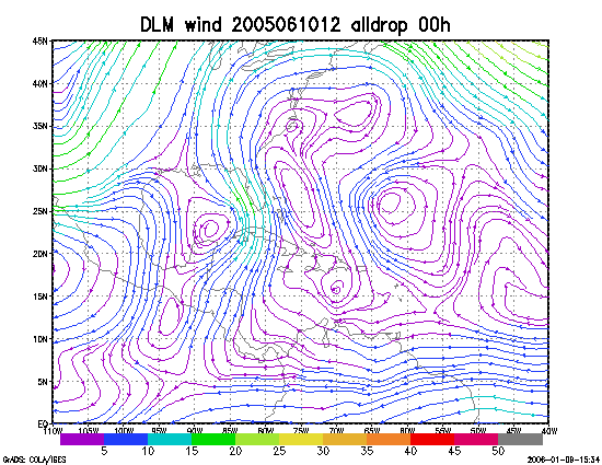
Figure 1. NCEP 850 - 200 hPa mean wind analysis for 10 June 2005 1200 UTC (Tropical Storm Arlene).
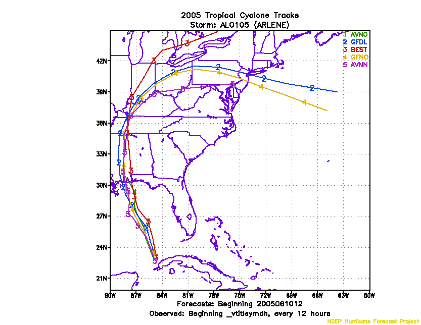
Figure 2. Track forecasts for the no dropwindsonde (NO or NN) and the all dropwindsonde (AL) runs for the AVN and GFDL models initialized on 10 June 2005 1200 UTC.
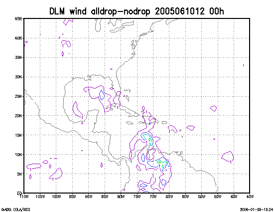
Figure 3. Initial condition differences in the 850 - 200 hPa mean wind between the no and all dropwindsonde cases for 10 June 2005 1200 UTC.