|
|
|
| Aircraft Commander |
| Co-pilot |
| Co-pilot |
| Navigator |
| Flight Engineer |
| Flight Director |
| System Engineer |
| Data Technician |
| Data Technician |
| LPS | John Gamache |
| Workstation | Paul Leighton |
| Dropsondes | Sam Houston |
| Radar | Mike Black |
| Radar | Neal Dorst |
Mission Plan :
At the time of mission briefing on 3 August, it was apparent from satellite imagery that Hurricane Guillermo had intensified since flight 970802H1. In fact the T numbers computed at the Tropical Prediction Center suggested that measurements made in Hurricane Guillermo might be a record for measurements made in Eastern Pacific hurricanes. Thus TPC requested that we document the intensity carefully. They were estimating pressures as low as 905 - 910 mb, and maximum winds of 145 knots. At the suggestion of Michael Black, it was decided that three sets of three GPS dropsonde drops would be made to document the eyewall. These drops should prove to be quite interesting. The decision was made to fly the pattern with the same orientations as on 2 August 1997.
Mission Summary :
| Take off | Landing
| Puerto Vallarta, Mexico | 16:49 UTC
| Puerto Vallarta, Mexico | 02:43 UTC
| | ||
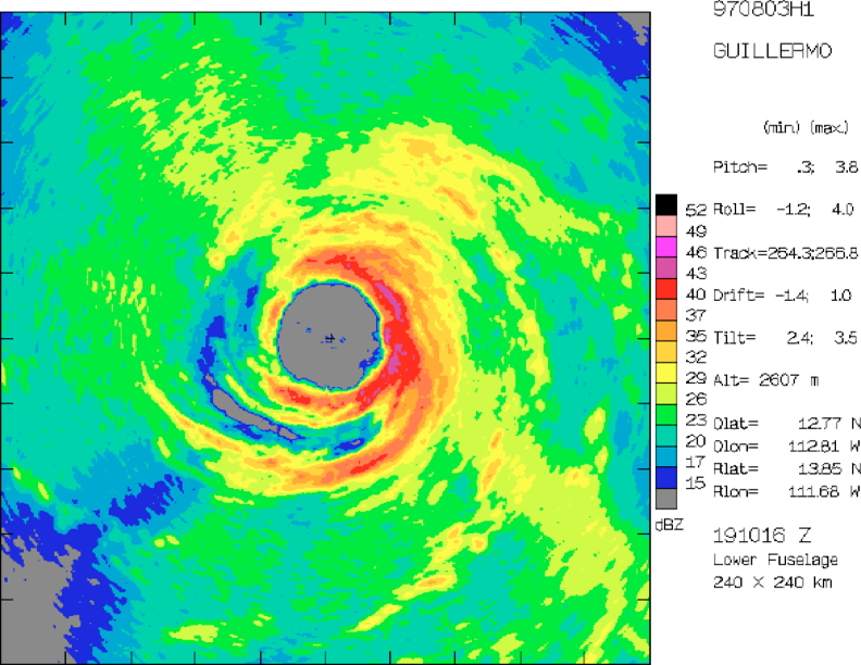
N42RF took of from Puerto Vallarta airport at 164910 UTC, ferrying at 16,000 ft to the IP. At 1829 UTC N42RF (14.4°N 109.0°W), the aircraft descended to the flight level of 10,000 ft PA, and reached the IP, 130 nm directly east of the estimated storm center. As on 2 August 1997, the mission began with a coordinated figure 4. The point 45 nm east of storm center (13.9°N 111.4°W) was reached at 1905 UTC, and the maximum flight level winds on the east side were 125 knots. Echo tops on this side were estimated to reach 17 km. The center was found at time 1910 UTC (13.9°N, 111.7°W, estimated MSLP 923 mb). The aircraft proceeded westward to the point 45 nm W of the storm center, and arrived at 1922 UTC (13.8°N 112.5 °W). On the west side reflectivities were quite low with low echo tops, except for a 3-4 km thick band of upper-level reflectivity (outflow?). N42RF then proceeded to a point 45 nm directly S of the storm center, reaching there at 1936 (13.2°N, 111.8 °W). The aircraft turned northward, finding maximum south side winds of 105 knots, and estimating the eye at 1945 UTC (13.8°N, 111.8°W, estimated MSLP 930 mb). As N42RF exited the storm the first set of three drops were made, one at 194829 UTC (14.1°N 111.8°W, inside the eyewall), the second at 195027 UTC (14.2°N 111.8°W, in the eyewall), and the third at 195315 UTC (14.4°N 111.8°W, just outside the eyewall). The second dropsonde reported a low-level wind maximum of 145 knots. Maximum flight level winds on the north side were 140 knots. The end of the coordinated figure 4 was at 195725 UTC (14.6°N 111.7°W).
The uncoordinated figure 4 followed. Two more center positions were estimated at 2018 UTC (13.8°N, 111.9°W, estimated MSLP 931 mb), and 2054 UTC (13.9°N, 112.0°W, estimated MSLP 930 mb). Maximum flight-level winds of 140, 135, 120, and 115 knots were found on the NW, NE, SE, and SW sides of the storm, respectively.
|
|
|
|
The second coordinated figure 4 began at 2115 UTC (13.2°N, 111.7°W) to the SE of the storm center. N42RF proceeded along nominal track 330, passing near the center; however, it was not possible to estimate the center position accurately on this pass. The N43RF estimate was 13.8°N, 112.1°W at 2124 UTC. Maximum flight level winds on the SE side were 110 knots on the SE side, and 140 knots on the NW side. Three drops were made during this flight leg, bracketing the SE eyewall. The drops were at 212030 UTC (13.5°N 111.8°W), 212307 UTC (13.7°N, 111.9°W), and 212516 UTC (13.8°N, 112.0°W). The last two had good winds, and all three had thermodynamic data. The NW end of the flight leg was reached at 2135 UTC (14.5°N, 112.4°W). A downwind leg was then flown to the next point at 2153 UTC (13.5, 112.7°W), where N42RF turned inward, and tracked along 60 degrees through the storm center. The storm center was found at 2202 UTC (13.8°N, 112.6°W, MSLP 929 mb), and the maximum flight-level winds on the SW and NE sides were 115 and 133 knots, respectively.
Then the second "uncoordinated" figure 4 for N42RF began, going from 2153 UTC (13.5°N, 112.7°W) and ending at 2328 UTC (13.4°N, 112.9°W). The aircraft waited there executing maneuvers, and began the next coordinated figure 4 at 2333 UTC (13.2°N 112.9°W). During the uncoordinated 4, two centers were estimated, one at 2231 UTC (13.9°N, 112.3°W, estimated MSLP 932 mb), and the second at 2306 UTC (13.9°N, 112.4°W, estimated MSLP around 923 mb, winds less than 3 knots). Maximum winds were 140, 105, 128, and 125 knots on the NE, SW, SE, and NW sides, respectively.
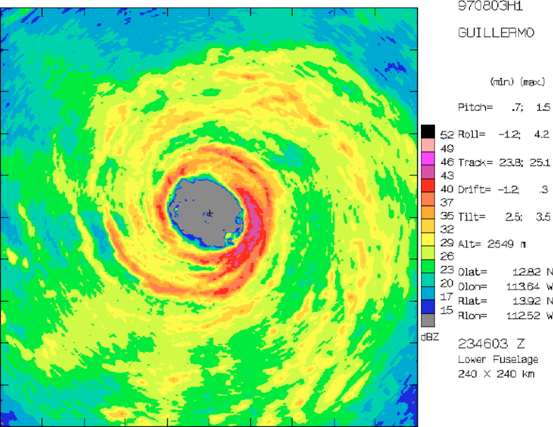
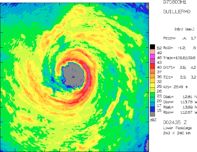
The third coordinated figure 4 began at 2333 UTC (13.2°N 112.9°W) to the SW of the storm center. N42RF flew a nominal track of 030, finding maximum flight level winds of 110 and 142 knots on the SW and NE sides, respectively, and a storm center at 2345 UTC (13.9°N, 112.5°W, estimated MSLP 926 mb) . Four drops were made along this flight leg. The first was in the SW eyewall at 234219. The other three bracketed the NE eyewall and were made at 234840 UTC, 235140 UTC (14.2°N, 112.4°W), and 235416 UTC (14.4°N, 112.3°W). The end of the flight leg was reached at 2357 UTC (14.6°N, 112.2°W), and N42RF then proceeded downwind to the next flight leg. That leg began at 0011 UTC (14.4°N, 113.4°W), along a nominal track of 120, and ended at 0036 UTC (13.6°N, 111.9°W). The center along that leg was estimated at 0025 UTC to be at 13.9°N, 112.6°W). Maximum flight-level winds on NW and SE sides on this flight leg were 120 knots. As in several previous passes through the SE eyewall, lightning was seen, and maximum echo tops were about 17 to 18 km. At 0036 UTC (13.6°N, 111.9°W) N42RF ended its mission and began its return to Puerto Vallarta, where it landed at 0243 UTC.
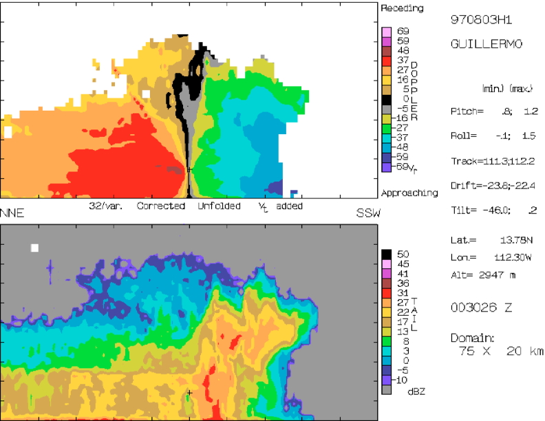
During this flight FAST (fore/aft scanning) mode was employed on the N42RF tail radar, except during radial penetrations in the coordinated figure 4's. Tail radars worked well on both aircraft, enabling us to follow the tail radar scanning to the letter.
Ten drops were made to observed the winds and thermodynamics in a near the hurricane eyewall. During each bracketing two out of three sondes reported winds, while all sondes reported thermodynamics. These drops should help use understand the vertical profiles of radial and tangential flow, as well as theta-e, in the hurricane eyewall.
Mission Evaluation:
This was yet again an excellent mission. On this day we observed a hurricane in more or less steady state, to complement the intensifying hurricane the day before. We should also be able to document the convection on the SE side of the storm, which was quite deep for hurricanes (17-18 km). The drops from N42RF in the eyewall are the first of their kind to work so well.
| Fix | Time | Location | MSLP | Comments | |
| (UTC) | (Lat °N) | (Lon °W) | (mb) | ||
| 1 | 1910 | 13.9 | 111.7 | 923 | coordinated with N43RF |
| 2 | 1945 | 13.8 | 111.8 | 930 | coordinated with N43RF |
| 3 | 2018 | 13.8 | 111.9 | 931 | |
| 4 | 2054 | 13.9 | 112.0 | 930 | |
| 5 | ~2124 | N/A | N/A | N/A | coordinated with N43RF |
| 6 | 2202 | 13.8 | 112.6 | 929 | coordinated with N43RF |
| 7 | 2231 | 13.9 | 112.3 | 932 | |
| 8 | 2306 | 13.9 | 112.4 | 923 | |
| 9 | 2345 | 13.9 | 112.5 | 926 | coordinated with N43RF |
| 10 | 0025 | 13.9 | 112.6 | coordinated with N43RF | |
| Drop | Time | Location | Comments | |
| (UTC) | (Lat °N) | (Lon °W) | ||
| 1 | 194830 | 14.035 | 111.790 | inside the N eyewall |
| 2 | 195030 | 14.161 | 111.769 | in the N eyewall |
| 3 | 195315 | 14.400 | 111.800 | just outside the N eyewall
NO WINDS, good PTH |
| 4 | 212030 | 13.500 | 111.800 | inside the SE eyewall
NO WINDS, good PTH |
| 5 | 212303 | 13.694 | 111.896 | in the SE eyewall |
| 6 | 212503 | 13.821 | 111.898 | just outside the SE eyewall |
| 7 | 234221 | 13.869 | 112.666 | in the SW eyewall |
| 8 | 234838 | 14.073 | 112.451 | inside the NE eyewall |
| 9 | 235142 | 14.244 | 112.363 | in the NE eyewall |
| 10 | 235416 | 14.400 | 112.390 | just outside the NE eyewall
NO WINDS, good PTH |
Problems :
John Gamache
Oct. 18, 1997