Mission Summary : 20010915H Aircraft
Tropical Storm Gabrielle
XCDX Experiment
Version with illustrations
| Take off :
| MacDill AFB, FL
| 17:58 Z
| September 15, 2001
|
| Landing :
| MacDill AFB, FL
| 01:18 Z
| September 16, 2001
|
| Scientific Crew
|
|
Lead Project Scientist | Frank Marks
|
| Radar Scientist | John Gamache
|
| Workstation Scientist | Peter Dodge
|
| Dropsonde Scientist | Mike Black
|
| CN/CCN scientist | Jim Hudson (DRI)
|
| AXBT Scientist |
Gary Barnes (U Hawaii)
Matt Eastin (CSU)
|
| Aircraft Crew:
|
| Pilots | Tennesen
Taggert
|
| Flight Engineer | Bast
|
| Navigator | Newman
|
| Flight Director | Shepherd
|
| Engineers | McMillan
Delgado
Lynch
|
- Penetrations: 6 (no hurricane)
- Expendables: 34 GPS-sondes, 18 AXBTs (2 bad)
- Tapes:
- 4 video
- 1 flight level DAT
- 1 radar DAT
- 1 Cloud Physics DAT
MISSION BRIEF:
HRD scheduled an extended cyclone dynamics experiment (XCDX)
mission into Tropical Storm Gabrielle with N42RF and the NASA
DC-8 and ER-2 aircraft for 15 September 2001. N42RF would take
off at 1600 UTC from MacDill AFB and recover at MacDill. The
NASA aircraft would take off from Jacksonville 45 minutes after
N42RF in order to coordinate our pattern. If the ER-2 couldn't
take off because of cross winds N42RF and the NASA DC-8 would fly
at coordinated pattern. N42RF and the DC-8 would fly an XCDX
pattern with six radials around the storm at radii 150 nmi from
the
center for N42RF and 250 nmi for the DC-8 (see Fig. 1). All legs
would be coordinated to attempt to cross the center at the same
time. The DC-8 would drop GPS sondes in the eye and at the end
points of each of the six radial legs. The radial legs to the
west and southwest would be truncated to stay off the coast.
N42RF would drop GPS sondes at the end points of each leg, and
at 25 nmi equally spaced locations within the inner 75 nmi of
the center of the storm to map the boundary layer structure. The
inner drops would have coincident AXBTs to map the air-sea
fluxes as the storm moved over the Gulf Stream.
MISSION SYNOPSIS:
At the 1200 UTC conference call with NASA we decided to slip the
aircraft take off by 2 h to see if the DC-8 and ER-2 could take
off as Gabrielle was still close to the east coast of Florida.
At the pilot briefing it was clear that the ER-2 would not be
able to participate, as the winds had not abated enough at
Jacksonville. N42RF departed MacDill AFB at 1758 UTC, passing
through bands of convection as we transited over Florida and
just off the east coast of Florida. Along our transit to the
storm we realized the storm was further north and east than we
planned for. So we shifted our and the DC-8 pattern to account
for the new center position (1900 UTC).
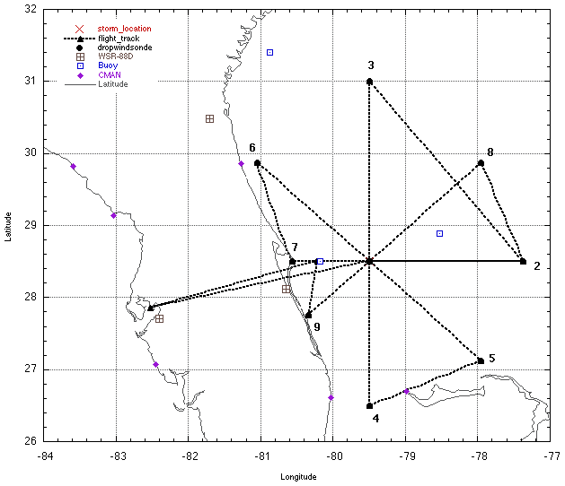
The first run into the center from the WSW was very difficult, as
the center at flight level (14000 ft) and that at the surface
(based on fixes from the AFRES) were roughly 25 nmi (40 km)
apart. Tom Shepard followed the flight-level winds, but they were
very light and variable. I attempted to assist by looking at the
structure in the low cloud field (there were was very little deep
convection south and west of the center). We fixed what we
thought was the surface center (south and east of the
flight-level center) at 1900 UTC and started tracking east to a
point 150 nmi (230 km) from the center. At the center we aligned
with the DC-8 directly overhead (visual siting) and tried to
maintain close coordination on the rest of the legs. As we
tracked east, dropping GPS sondes and AXBts every 25 nmi out to
75 nmi (Fig. 2), we noted that the surface circulation as
indicated from the sonde surface winds was actually east and a
little north of the center we fixed. So we started trying to
estimate where the center would be for the next leg to pass up
to the DC-8. We reached the end of the first leg (2) at 1928
UTC. During the leg we heard from N49RF as they continued their
surveillance pattern dropping GPS sondes within 150 nmi north
and east of our new center.
We tracked northwest to a point 150 nmi north of our estimated
center position (3) for the next leg. We dropped 3 equally spaced
AXBTs along this diagonal leg 150-190 nmi northeast of the
center, roughly along the intended track. The SST was between
28° and 28.5° C along the leg as we passed over the Gulf
Stream axis. We also passed across the major rainband just inside
the major convective feature with tops to near 15 km and
reflectivity near 50 dBZ (Fig. 3). We reached (3) at 2008 UTC
and noted the center appeared to be 20 nmi further east than we
anticipated. So we adjusted the DC-8 and our north to south
track further east.
Tracking south to the center we entered the major rainband north
of the center at 75 nmi radius. This rainband was mainly
stratifonn in nature, but the bright band was relatively strong,
with reflectivity of 40-45 dBZ. The GPS sondes showed that the
wind tumed considerable with height in this rainband from near
easterly at flight level to northeast at lower levels, with peak
velocities over 25 m/s. We passed through the inside edge of the
rainband 25 nmi north of the center and fixed a flight level
center at 2036 UTC. We proceeded south 150 nmi in relatively
clear air noting a low-level swirl in the clouds which were
likely at the surface center (Fig. 4). The only other remarkable
sight was a band of high surface winds (evidenced by white caps
and streaks on the surface) over a very broad area starting about
25 nmi south of the center almost to the end of our leg 150 nmi
south of the center (4) (Fig. 5). The GPS sondes indicated that
the surface winds had peaks near 18-20 m/s. We reached (4) at
2100 UTC and tumed northeast to a point 150 nmi southeast of the
center (5).
Along the short leg to (5) we estimated a new center location
for the next coordinated leg with the DC-8. We reached (5) at
2123 UTC and tumed tracking northwest to the center. Jim Hudson
reported some very interesting CN/CCN observations in the clear
slot southeast of the center, with interesting radial gradient
of CN in an area devoid of deep convection. Once again we passed
over the broad area of surface winds visible in the sea state
from flight level. The GPS sondes once again showed increased
surface winds near 20 m/s. We hit the center at 2148 UTC and
tracked across the major rainband 30 nmi northwest of the center.
It was pretty clear the center was tracking northeast (50°)
at 7 m/s. We reached (6), 150 nmi northwest of the center, at
2213 UTC. (6) was only 25 nmi south of Charleston, SC (Fig. 2)
(the DC-8 point was near Columbia, SC) and GPS sondes showed
that the surface temperatures were near 24° C.
Once again we estimated the position of the center for the next
coordinated leg to pass to the DC-8. We tracked southwest to a
point 150 nmi west of the estimated center for the next leg (7).
We reached (7) at 2227 UTC and tumed east to the center. This
leg passed south of the rainband as it didn't wrap around the
west side of the center. We did encounter strong surface winds
once more from the GPS sondes as well as in the sea state. The
center wasn't as far east as we anticipated so we did not drop a
sonde 25 nmi W of the center. We reached the center at 2259 UTC
and proceeded to (2) 150 nmi east of the center. We didn't drop
any GPS sondes on this leg because we had already dropped them
east of the center. We reached (2) at 2324 UTC and tumed north to
(8) 150 nmi northeast of the center which was in the middle of
the deep convection which was closer to the center than the
first time we passed it. We also leamed that the DC-8 had cut
the pattern and had proceeded from the center directly to their
(8) missing a pass through the major convection.
We proceeded to (8) along the convective feature and proceeded to
pick our way through the strong cells (2328 UTC). We had to make
a choice of passing through the band and then tuming further east
to get to (8), or we could pick up the radial 90 nmi from the
center. When we found out that the DC-8 had cut their pattern
short we opted to start at 90 nmi to try to stay coordinated on
the final leg. We started the leg at 2344 UTC in the rainband. On
our inbound leg we made contact with the next AFRES aircraft
entering the storm from the west passing them our estimated
center position for this leg. Unfortunatley, the radar went down
for about 5 min at 2356 UTC, while we were in stratiform rain and
convective cells. Luckily it came back up about 25 nmi from the
center at 0001 UTC. We hit the flight level center at 0005 UTC,
which tumed out to be 28 nmi north of the AFRES fix at 1500 ft.
We proceeded southwest to (9) 150 nmi southwest of the center
dropping GPS sondes 25, 50, 75, and 150 nmi radius. We reached
(9) at 0031 UTC and then proceeded back to MacDill. landing at
0118 UTC (7.9 h mission).
SUMMARY :
A very good mission! Good coordination with the DC-8 by the N42RF
crew (primarily Carl Newman and Tom Shepherd). We completed the
pattern as briefed with a few wrinkles for flight safety. On the
first inbound leg from the west we moved the whole pattern to the
northeast when we realized the center was much further north and
off the coast.
The storm structure was very interesting, with only one large
rainband wrapping around the north and east side of the center.
East of the center the band was 150-200 nmi from the center to
about 30- 40 rim north of the center (Fig. 3). The surface
circulation was well south and east of the flight-level center
(20-25 nmi). The region south and east of the center was very dry
with only small convective clouds. However, the sea state south
and east of the center indicated a region of strong surface
winds 18-25 m/s surrounding a broad center 50 m-n across. During
the mission the only deep convective features were to the
northeast of the center (Fig. 3) about 120 nmi from the center
where the cloud tops were near 15 kin and the reflectivity was
near 50 dBZ.
Jim Hudson noted some very interesting radial gradients of CN/CCN
surrounding the center. He noted differences in the aerosol
concentrations between the clear air southeast of the center and
that near the convection to the north. The AXBTs revealed that
the SST was running between 28.5-29.0 °C over a large domain
that the storm was over. It appeared the storm was moving right
over the Gulf Stream axis. By the time we left the storm the
convection was getting more vigorous and it appeared the storm
was much better organized than when we arrived, certainly
deserving tropical storm status.
I think the analysis of this flight will prove very useful in
diagnosing how a storm gets better organized out over open water
with relatively high SSTs. I suspect with the phenomenal GPS
sonde coverage over such a large area from N42RF, DC-8, and G-IV
(which apparently passed within the DC-8 pattern on the east
side of the storm), combined with the AXBT coverage will provide
a great data set for air-sea interaction and trough interaction
studies of a slowly intensifying storm. Combined with the data
set from the next day when Gabrielle returned to hurricane status
it will be even more valuable.
PROBLEMS:
- The HVPS worked on the bench before take off, but wouldn't
work when it was mounted on the aircraft. AOC engineers
recognized the problem but could not repair it or come up with a
solution before the flight. They are looking into a solution.
- The radar system crashed at 2356 UTC during the leg from the
NE. Sean McMillan restarted the system and it was back up by 0001
UTC. There was another short restart between 21132114 UTC. It
worked perfectly the rest of the flight until the end when the
transmitter had a component bum up at landing.
Frank Marks
19 September 2001
Table 1
GPS dropsondes
|
| Number
| Sonde Id
| Time (UTC)
| Lat.
(deg)
| Lon.
(deg)
| 150-m
wind
| DLM
wind
| MBL
wind
| SST
(°C)
| Comments
|
|
1 | 003338014 | 15:18:59:00 | 29.81 | -79.20 | 01013 | 34016 | 1015 | | Center
|
|
2 | 003155019 | 15:19:08:00 | 29.84 | -78.71 | 33507 | 29008 | 33506 | 28.5 |
|
|
3 | 003155017 | 15:19:13:00 | 29.87 | -78.22 | 23511 | 21514 | 24011 | 28.5 |
|
|
4 | 003438008 | 15:19:18:00 | 29.91 | -77.73 | 18528 | 19532 | 19030 | 28.0 |
|
|
5 | 003135113 | 15:19:27:00 | 29.93 | -76.87 | 18535 | 20046 | 18538 | 28.2 |
|
|
6 | 003248075 | 15:20:08:00 | 32.26 | -79.05 | 03046 | 05534 | 3548 | 27.5 | RAINBAND
|
|
7 | 003338080 | 15:20:21:00 | 31.49 | -78.92 | 03541 | 04538 | 04045 | 28.0 | RAINBAND
|
|
8 | 003135351 | 15:20:27:00 | 31.08 | -78.87 | 03044 | 05043 | 02549 | 28.0 | LST WND 011 RAINBAND
|
|
9 | 003155016 | 15:20:36:00 | 30.47 | -78.93 | 03525 | 03518 | 03028 | 28.4 |
|
|
10 | 003115222 | 15:20:33:00 | 30.69 | -78.95 | 02034 | 03527 | 02533 | |
|
|
11 | 003115212 | 15:20:40:00 | 30.14 | -78.89 | 01516 | 00514 | 02018 | |
|
|
12 | 003155021 | 15:20:45:00 | 29.73 | -78.87 | 32013 | 30516 | 32513 | |
|
|
13 | 003135041 | 15:20:50:00 | 29.32 | -78.85 | 28020 | 28523 | 28019 | |
|
|
14 | 003135006 | 15:21:00:00 | 28.59 | -78.86 | 27022 | 27526 | 27522 | 29.0 |
|
|
15 | 003338066 | 15:21:23:00 | 29.49 | -76.73 | 21043 | 21545 | 20543 | |
|
|
16 | 003135344 | 15:21:33:00 | 29.97 | -77.31 | 21524 | 22033 | 21527 | 28.0 |
|
|
17 | 003135112 | 15:21:38:00 | 30.23 | -77.74 | 23013 | 22516 | 23014 | |
|
|
18 | 003438011 | 15:21:42:00 | 30.45 | -77.98 | 03515 | 03503 | 03013 | |
|
|
19 | 003115248 | 15:21:48:00 | 30.60 | -78.38 | 03525 | 03518 | 03525 | |
|
|
20 | 003135102 | 15:21:52:00 | 30.80 | -78.71 | 02538 | 03531 | 02538 | |
|
|
21 | 993925312 | 15:21:58:00 | 31.07 | -79.11 | 03544 | 03040 | 03547 | | LST WND 024
|
|
22 | 990148032 | 15:22:13:00 | 31.80 | -80.14 | 02040 | 04033 | 01541 | | LST WND 011
|
|
23 | 994335232 | 15:22:27:00 | 30.72 | -80.63 | 01046 | 02533 | 01546 | |
|
|
24 | 994015040 | 15:22:40:00 | 30.71 | -79.57 | 02042 | 02038 | 02046 | |
|
|
25 | 990435520 | 15:22:47:00 | 30.43 | -79.04 | 02045 | 02541 | 02046 | |
|
|
26 | 993915072 | 15:22:58:00 | 30.66 | -78.20 | 04037 | 05018 | 04038 | |
|
|
27 | 994325184 | 15:23:49:00 | 31.80 | -77.15 | 05049 | 07530 | 05050 | |
|
|
28 | 994015040 | 15:23:54:00 | 31.45 | -77.47 | 03552 | 06532 | 04052 | |
|
|
29 | 011218036 | 16:00:00:00 | 31.06 | -77.63 | 02530 | 05014 | 03530 | 28.0 |
|
|
30 | 993925184 | 16:00:11:00 | 30.49 | -78.20 | 02539 | 02529 | 03041 | |
|
|
31 | 990845120 | 16:00:16:00 | 30.25 | -78.53 | 01533 | 01029 | 01036 | |
|
|
32 | 993925184 | 16:00:21:00 | 29.98 | -78.88 | 00538 | 36047 | 00544 | |
|
|
33 | 992515712 | 16:00:31:00 | 29.55 | -79.55 | 36035 | 35532 | 00536 | |
|