 Flight track |
 Temperature and Moisture |
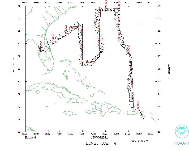
 Wind and Atlitude |
| Aircraft crew (N43RF) | |
| A/C Commander | Phil Kennedy |
| Co-pilot | Phil Kenul |
| Navigator | Steve Kozak |
| Flight Engineer | Greg Bast |
| Flight Engineer | Butch Moore |
| Flight Director | Stan Czyzyk |
| Flight Director | Barry Damiano |
| Radio | Daemon San Souci |
| System Engineer | Terry Lynch |
| Radar Technician | R McNamara |
| System Engineer | Jorge Gonzalez |
| Mechanic | G Closser |
| Program Manager | E McNierney |
| Scientific crew | |
| Chief Scientist | Frank Marks |
| Radar Scientist | Peter Dodge |
| Doppler Scientist | Sim Aberson |
| Cloud Physics | John Kaplan |
| Wokstation | Paul Leighton |
This document is divided into 3 sections (Each section is written by the Chief Scientist):
| Take off | Landing
| St. Croix, USVI | 17:43 UTC
| MacDill AFB, FL | 03:45 UTC
| Penetrations
| 0
| | ||||
N43RF took off at 1744 UTC. Our track to the N side of the storm took us up along one of the major rainbands ~150-180 nm on the E side of Edouard. We entered the edge the rainband at 1904 UTC (22.5 N, 66.25 W). As we tracked N along the rainband we collected Doppler radar (in FAST), cloud microphysics, and electric field data in ice. At 1933 UTC (24.8 N 67.1 W) we passed 150 nm due E of the center of Edouard. The radar indicated that there was a double eyewall, one with a diameter of 15 nm and the second at a diameter of about 50 nm (verified later by 42RF). At 1953 UTC (27 N, 66.5 W) we were in a strong vertical shear zone in the large stratiform rain shield ~180 nm NE of the center. The wind shifted from S to ESE in a few minutes as we passed through a heavy stratiform region with embedded convective cells (excellent Doppler data). We finally passed out of the precipitation in the bands around 2010 UTC. There is a lot of good radar and microphysics data along this portion of the track. The radar system failed once from 1916-1923 UTC and once again right after we passed out of the precipitation at 2010 UTC.
From 2010 UTC to 2100 UTC we passed through very suppressed air in the ridge axis. The first ODW was dropped on the ridge axis as the flight level winds went calm. We proceeded N into a region of prefrontal rainbands oriented ENE-WSW with some extremely intense cells scattered along the band. At 2109 UTC we passed very close to one of these cells (we had to deviate the track to get around it) with reflectivities exceeding 50 dBZ and tops of 45 kft. At 2133 UTC we reached our N most point and tracked W along 34.5 N latitude toward a precipitation band associated with the frontal boundary. Our next turn point (34.5 N, 72 W) at 2216 UTC was in the band of cells. We managed to drop the ODW in a clear spot between cells into the frontal boundary. From 2216-2240 UTC we tracked S, 40 nm W of a N-S oriented convective line that merged on the N side with the frontal band of precipitation (might have been associated with a wave on the front). From 2240-2310 UTC we tracked through the suppressed air in the ridge axis once again, dropping the third ODW at 2305 UTC (30.5 N , 72 W) in the ridge axis.
At 2348 UTC (27 N, 72 W) we turned SW to pass ~200 nm to the W of the storm. Along the next leg we contacted 42RF and discussed their pattern. They had a double eyewall of 12 and 45 nm diameters, fixing the center twice. The central pressure was 944 mb. Due to fuel considerations we decided to cut the track short by eliminating point 18 and 20 from the pattern. The last ODW was dropped NW of the frontal boundary at 0152 UTC (32 N, 75 W). We turned tracking toward the SW on the way back to Tampa. We finished the pattern at 0235 UTC (30 N, 78.4 W) and climbed to ferry to MacDill AFB.
1. Radar system failures during the first N-S leg along the rainband at 1916-1923 UTC caused some missed data in the rainband.
2. The work station crashed during the last dropsonde, which resulted in the sonde being coded by hand.
Frank Marks
|
Flight track |
Temperature and Moisture |
Wind and Atlitude |
Return to mission page.
Return to Edouard page.