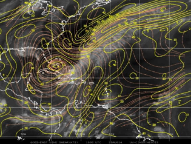
Figure 1: CIMSS wind shear (yellow) and wind (orange) displayed over GOES IR image valid at 18Z 8/25 |
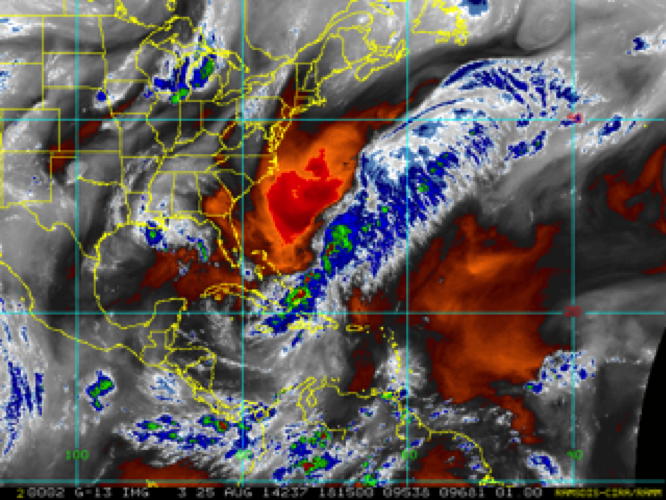
Figure 2: CIMSS water vapor from METEOSAT valid at 20Z 8/25 |
| Aircraft Commander | Justin Kibbey |
| Co-pilot | Robert Mitchell |
| Co-pilot | Scott Price |
| Navigator | Pete Siegel |
| Flight Engineer | Joe Klippel |
| Flight Engineer | Chris Lalonde |
| Flight Director | Ian Sears |
| Flight Director | Mike Holmes |
| System Engineer | Dana Naeher |
| Data Technician | Joe Greene |
| AVAPS | Jeff Smith |
| LPS | Kathryn Sellwood (HRD) |
| Dropsondes | Hua Chen (HRD) |
| Radar | Sim Aberson (HRD) |
| SFMR | Heather Holbach (FSU) |
| IWRAP | Paul Chang (NESDIS) |
| IWRAP | Zorana Jelenak (NESDIS) |
| IWRAP | Steve J Frasier (NESDIS) |
Mission Plan :
NOAA43 will conduct an EMC-tasked TDR Experiment into Tropical Storm Cristobal Conduct an EMC tasked TDR pattern in Tropical Storm Cristobal which was moving slowly northward in the eastern Bahamas. The aircraft will take off from MacDill AFB, FL at 1800 UTC and recover at MacDill AFB, FL at 0400 UTC. The forecast called for increasing north to northeastward motion and continued slow intensification. Cristobal had strengthened moderately since the previous night's flight with 50kt winds and a 993mb central pressure but the convection was still confined to the east side of the storm (fig 6) . An upper level trough with a surface front was positioned just north and west of the storm and there was a large region of dry air to the west-northwest of the storm (fig 1,2,5). There was still plenty of moisture from the south feeding the strongest convection on the southeast side of the storm. Cristobal was forecast to reach minimal hurricane strength within the next 36 hours as the wind shear over the storm was expected to relax. Convection about the storm center was beginning to increase at the takeoff time raising the potential for sampling the formation of a convective burst occurrence during the flight.
|
Figure 1: CIMSS wind shear (yellow) and wind (orange) displayed over GOES IR image valid at 18Z 8/25 |
Figure 2: CIMSS water vapor from METEOSAT valid at 20Z 8/25 |
The flight plan (fig 3.) called for a butterfly pattern with 120 nautical mile legs, entering the storm from the west and finishing to the northwest at a height of 10,000ft. Dropsondes were planned for the midpoints of each leg and at the center. Once again the GIV was sampling the environment at the same time and no endpoint drops were requested. The primary objective was to provide real time radar analyses for assimilation into the HWRF model with the secondary objectives of obtaining high incidence angle SFMR data and to conduct sector scans for NESDIS. Plans were made to conduct a convective burst module on the southeast side of the storm in the event that convection should start to rapidly develop. The module was to consist of a box pattern around the convective feature with drowindsondes in each quadrant. The AVAPS operator, Jeff Smith had a number of mini dropsondes and IR sensor dropsondes which were to be tested in the maximum wind region along with a BT and a GPS sonde for comparison. Extra dropsondes were prepared for the possibility of sampling the radius of maximum wind speed should an eyewall begin to form.
|
Hurricane Research Division Augus 2, 2014 03:45 PM Aircraft: N49RF Proposed takeoff: 03/1730Z
TURN LOCATIONS
| #
| LAT
| LON
| RAD/AZM
| LEG
| TOTAL
| TIME
|
| deg min
| deg min
| nm/dg
| nm
| nm
| hr:mn
| 2 | 22 00 | 73 18 | 100/270 | 613. | 613. | 2:41
| 3 | 22 00 | 69 42 | 100/090 | 200. | 813. | 3:33
| 4 | 23 27 | 70 37 | 100/030 | 100. | 914. | 4:00
| 5 | 20 33 | 72 23 | 100/210 | 200. | 1113. | 4:53
| 6 | 20 33 | 70 37 | 100/150 | 100. | 1214. | 5:20
| 7 | 23 27 | 72 23 | 100/330 | 200. | 1414. | 6:13
| | ||||||||||||||
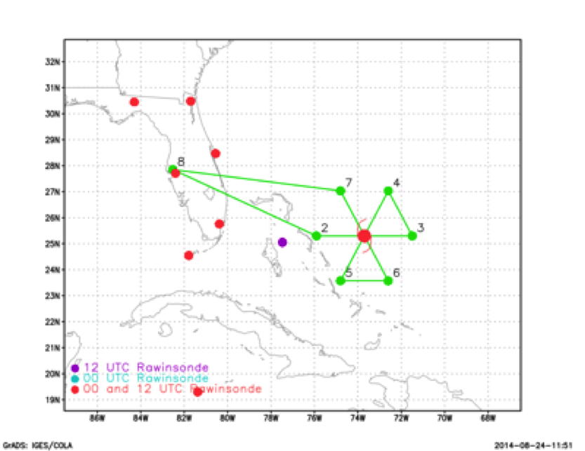
Figure 3: planned flight track |
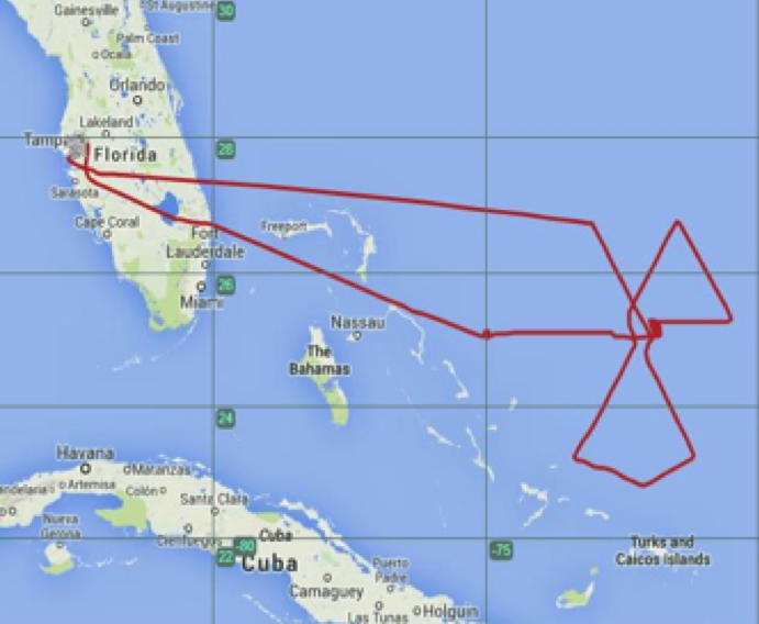
Figure 4: actual track flown |
| Take off | Landing
| MacDill AFB, FL | 17:53 UTC
| MacDill AFB, FL | 01:43 UTC
| Penetrations
| 1
| | ||||
Takeoff was at 1753Z from MacDill Air Force base in Tampa Fl. During the first pass through the storm the flight director suggested that we conduct the SFMR tests here. Since the ferry was longer this flight and convection was beginning to fire up a, decision was made to go ahead and get this pattern in while it was still possible as it was already too late to get a radar analysis into the 18Z cycle. As in the previous flight 3 circles at 15°, 30° and 45° incidence angles were conducted in clear air, this time with 20-25m/s surface winds. The central pressure dropped steadily during the flight to 990 mb and the maximum observed surface winds were 62 and 71kts from dropsonde and SFMR respectively. A special 8:00 EDT advisory was issued upgrading Cristobal to hurricane status based on these observations. Once again the strongest winds were found on the southeast side of the storm. This is evident in the radar composites shown in figures 6 and 7 which also indicate a more upright structure compared with the previous flight. Extra dropsondes were released to try and sample the RMW, first on the east side of the storm and then on the southeast side but missed the strongest winds. An IR dropsonde, a mini dropsonde and an AXBT were launched at the midpoint of the southeast leg along with the GPS sonde. All sondes
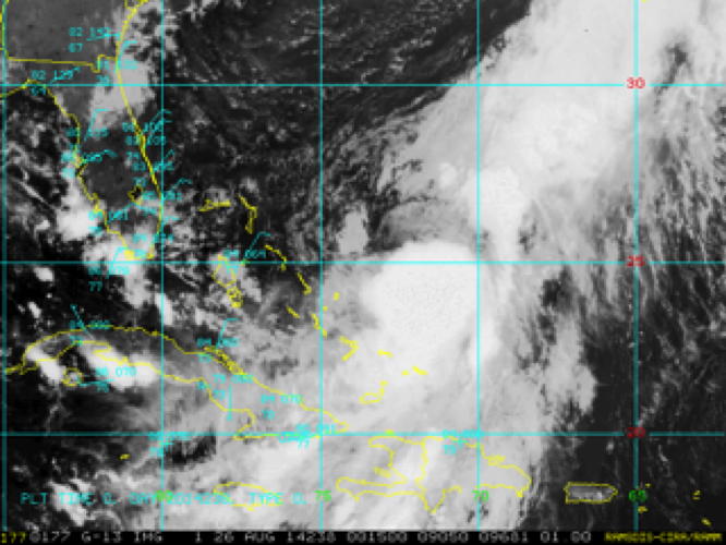
Figure 5: GOES visible image valid 18Z 8/25 |
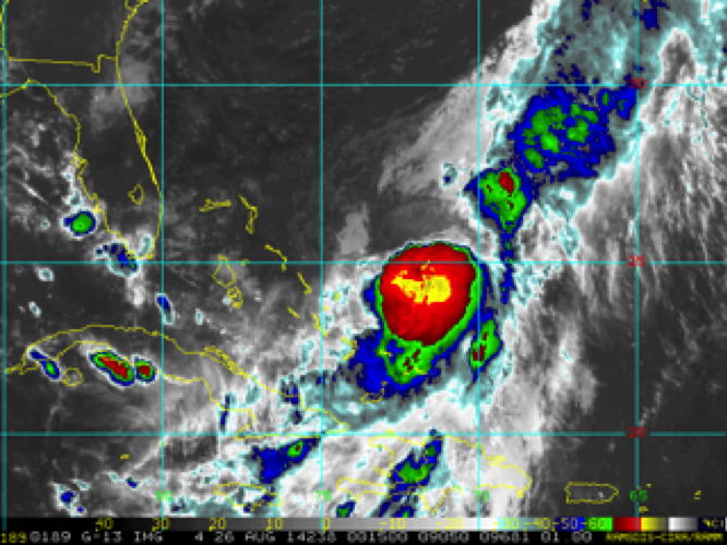
Figure 6: GOES IR color image valid 18Z 8/25 |
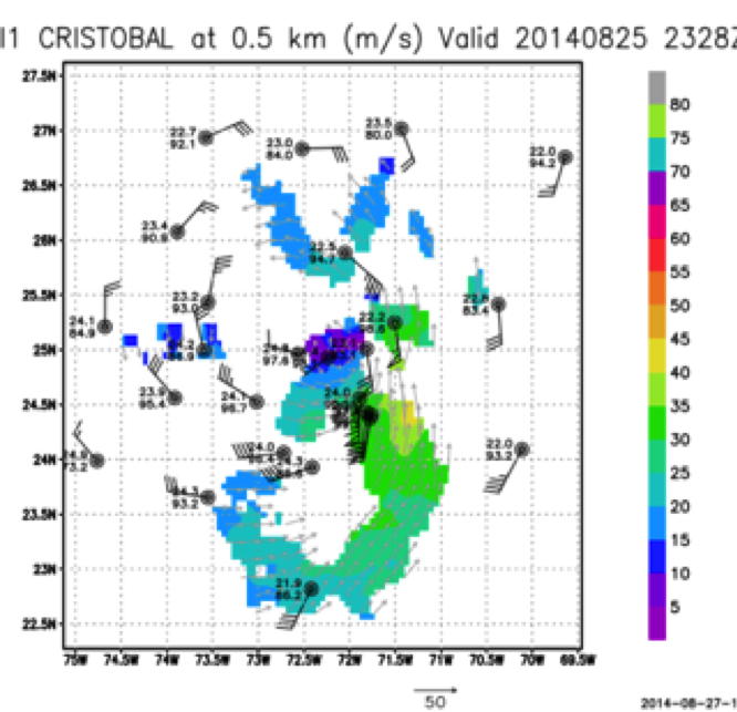
Figure 7a: Radar, dropwindsonde composite wind speed at lowest radar level |
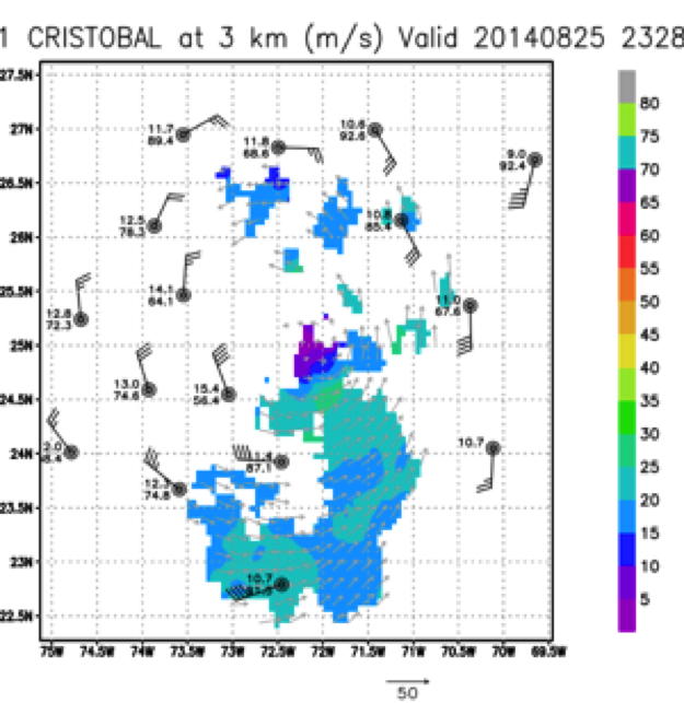
Figure 7b: Same as figure 6 but at 3km aproximate flight level |
transmitted to the surface but the SST retrieved by the IR sonde was 4 to 5 degrees cooler than measured by the BT, probably due to rain contamination. During the final pass strong convection began to develop over the center (fig 5,6)and a convective burst module was attempted and aborted due to heavy turbulence and frequent lighting. The fortuitous location of the GIV aircraft provided thermodynamic data across this convective feature which together with the P3 data should provide much needed information about its structure and evolution. Once we were past the center, the lower fuselage radar was put in wedge mode and NESDIS was able to conduct their sector scans. A total of 13 GPS dropsondes, 1 mini dropsonde, 1 IR sonde and one AXBT were released. All GPS sondes were processed and transmitted in real time. The flight ended at 0143Z on August 26, landing at MacDill.
Mission Evaluation and Problems :
All mission objectives were successfully completed but the first radar analysis was received too late to be ingested into the 18Z HWRF cycle. Since this was our primary tasking it was noted that an earlier takeoff time might be necessary in order to get this important data into the model. Completing the first figure 4 pattern prior to attempting any modules was deemed to be essential to getting the data into the model as well as providing situational awareness for safety purposes.
Dropsondes launched 19-GPS, 1-IR, 1-mini, and 2 AXBT
Kathryn Sellwood
Nov. 5, 2014
Flight Director log | Flight Director manifest | LPS log | Radar log | Drop log