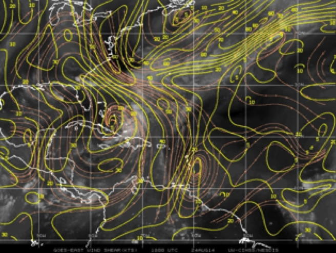
Figure 1: CIMSS wind shear (yellow) and wind (orange) displayed over GOES IR image. Image valid 18Z 08/24 |
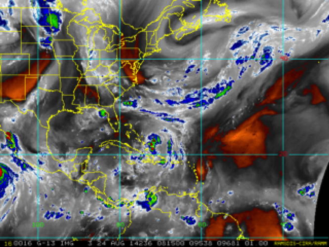
Figure 2: CIMSS water vapor from METEOSAT Image valid 20z 08/24. |
| Aircraft Commander | Justin Kibbey |
| Co-pilot | Robert Mitchell |
| Co-pilot | Scott Price |
| Navigator | Pete Siegel |
| Flight Engineer | Joe Klippel |
| Flight Engineer | Chris Lalonde |
| Flight Director | Ian Sears |
| Flight Director | Mike Holmes |
| System Engineer | Dana Naeher |
| Data Technician | Joe Greene |
| AVAPS | Jeff Smith |
| LPS | Kathryn Sellwood (HRD) |
| Dropsondes | Hua Chen (HRD) |
| Radar | Sim Aberson (HRD) |
| SFMR | Heather Holbach (FSU) |
| IWRAP | Joe Sapp (NESDIS) |
| IWRAP | Steve J Frasier (NESDIS) |
| Press | Terry Cassidy (Garry & Terry Show) |
Mission Plan :
NOAA43 will conduct an EMC-tasked TDR Experiment into Tropical Storm Cristobal which was slowly meandering in the southeast Bahamas. The aircraft will take off from MacDill AFB, FL at 1800 UTC and recover at MacDill AFB, FL at 0400 UTC.
|
Figure 1: CIMSS wind shear (yellow) and wind (orange) displayed over GOES IR image. Image valid 18Z 08/24 |
Figure 2: CIMSS water vapor from METEOSAT Image valid 20z 08/24. |
The forecast called for slow north to northeastward motion for the duration of the flight and slow intensification over the next 3-4 days. Although the analyzed wind shear (Fig. 1) was relatively weak over Cristobal, the convection was confined to the east side of the storm (fig 3.) suggesting that the shear was having a greater than expected influence on the storm. Another factor possibly inhibiting the convection was the fairly large area of dry air to the west-northwest of the storm (fig 2.). Otherwise there was an ample supply of moisture from the south helping to maintain the strongest convection on the southeast side of the storm (fig 4). Cristobal was forecast to slowly intensify reaching hurricane strength within the next 3 days. The main scientific objective of the flight was to gather simultaneous wind and thermodynamic data in order to develop a better understanding of the effects of shear and dry air on intensification processes.
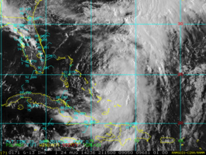
Figure 3: GOES visible image valid 18Z 08/24 |
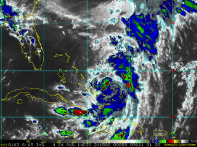
Figure 4: GOES IR color image valid 18Z 08/24 |
The flight plan (fig 5.) called for a butterfly pattern with 105 nautical mile legs, entering the storm from the west and finishing to the northwest at a height of 10,000ft. Dropsondes were planned for the midpoints of each leg and at the center. Since the GIV was sampling the environment at the same time no drops were planned further from the storm center. Due to transmission problems on the previous flight the mission was not tasked by EMC but the primary objective was still to provide them with real time radar analyses for assimilation into the HWRF model. Secondary objectives were to obtain high incidence angle data from the SFMR if a suitable location could be identified and to conduct sector scans for NESDIS. The requirements for the SMFR tests were sufficiently high winds (>15m/s) in a rain free region in order to minimize SFMR errors that are not due to the tilt of the aircraft. These observations are to be used to develop an algorithm to retrieve surface winds while the aircraft is turning. After the TDR pattern is completed sector scans were to be conducted for the NESDIS group on the final leg of the pattern, outward from the storm center. However, if any particularly interesting storm features were to develop, the sector scans would be eliminated in order to avoid the loss of lower fuselage data.
|
Hurricane Research Division Augus 2, 2014 03:45 PM Aircraft: N49RF Proposed takeoff: 03/1730Z
TURN LOCATIONS
| #
| LAT
| LON
| RAD/AZM
| LEG
| TOTAL
| TIME
|
| deg min
| deg min
| nm/dg
| nm
| nm
| hr:mn
| 2 | 22 00 | 73 18 | 100/270 | 613. | 613. | 2:41
| 3 | 22 00 | 69 42 | 100/090 | 200. | 813. | 3:33
| 4 | 23 27 | 70 37 | 100/030 | 100. | 914. | 4:00
| 5 | 20 33 | 72 23 | 100/210 | 200. | 1113. | 4:53
| 6 | 20 33 | 70 37 | 100/150 | 100. | 1214. | 5:20
| 7 | 23 27 | 72 23 | 100/330 | 200. | 1414. | 6:13
| | ||||||||||||||
Mission Summary :
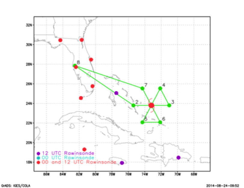
Figure 5: planned flight track, actual track moved point #6 further to the north and west |
| Take off | Landing
| MacDill AFB, FL | 17:55 UTC
| MacDill AFB, FL | 01:24 UTC
| | ||
Takeoff was at 1755Z from MacDill Air Force base in Tampa Fl. During the ferry to the storm the final radar analysis from the previous NOAA 43 flight was remade and sent to AOML as it had not finished successfully in real time. The AOC FTP site was still down at the beginning of the flight so the first 2 jobfiles for the radar analyses had to be created on the plane. By the final leg the ftp capability was restored and the third jobfile was created on the ground. Despite minor glitches due to the temporary FTP location, three radar analyses were created and FTP'd from the aircraft in sufficient time to be ingested into the 18Z and 0Z cycles of HWRF. As the flight progressed the convection near the storm center increased but remained on the eastern half of the storm. The storm center found on the first pass was to the south of that previously marked by the airforce, otherwise, the storm remained nearly stationary During the second pass through the storm 3 circles at 15°, 30° and 45° incidence angles were conducted in clear air with 15m/s surface winds for the SFMR test. The downwind flight leg on the south side had to be cut short in order to avoid strong convection during the turn. The largest SFMR surface winds of 44kts were observed during this turn but there was not sufficient time to prepare and release a dropsonde here. The strongest dropsonde surface winds of 39kts were obtained at the eastern midpoint on the first pass through the storm. The minimum observed surface pressure was 999mb on all passes. Radar , dropwindesonde composites (fig 5 and 6) indicate the strongest winds on the southeast side and suggest a eastward tilting vortex. During the final pass the lower fuselage radar was put in wedge mode as NESDIS conducted their sector scans. A total of 10 dropsondes were released, processed and transmitted in real time. The flight ended at 0125Z on August 25, landing at MacDill.
10 dropsondes launched, No AXBTs
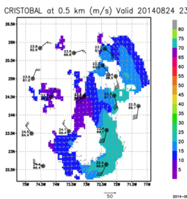
Figure 6: Radar, dropwindsonde composite wind speed at lowest radar level |
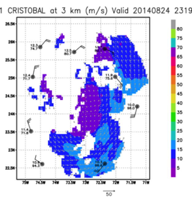
Figure 7: Same as figure 6 but at 3km approximate flight level |
Mission Evaluation and Problems :
All mission objectives were successfully completed. Although the FTP problem was fixed by the end of the flight there were some problems encountered creating the TDR analyses due to inconsistencies between the scripts and the FTP address. The FTP issues also caused the MTS tool to lose the aircraft. The alternative tracking site, Tropical Atlantic was also unable to track the aircraft because the HDOBS were not being transmitted. This would have made processing the data on the ground extremely difficult if no HRD personnel were aboard the aircraft. A minor bug in the ASPEN dropsonde processing software was encountered while creating skew T diagrams which was reported to the developers and had since been fixed.
Kathryn Sellwood
Nov. 5, 2014
Flight Director log |
Flight Director manifest |
LPS log |
Radar log |
Drop log
Page last updated Sept 5, 2014
Return to Mission page.