| Scientific Crew | |
| Lead Project Scientist | CDR Sean White |
| Radar Scientist | Peter Dodge |
| Workstation Scientist | Mike Black |
| Dropsonde Scientist | Mike Black |
| AXBT Scientist | Manuel Lonfat (RSMAS) |
| SFMR Scientist | Tony Castells (UMASS) |
| Aircraft Crew | |||
| Pilots | CAPT Dave Tennesen | LCDR Harris Halverson | LT Randall TeBeest |
| Flight Engineer | Greg Bast | ||
| Navigators | LT Carl Newman | LT John Adler | |
| Flight Directors | Tom Shepherd | Barry Damiano | |
| Engineers | Sean McMillan | Jim Roles | Jeff Smith |
Mission Brief:
Tropical Storm Barry was forecast to make landfall between 00-06Z on 6 August, 2001. The NHC tasked N42RF and the UMASS/SFMR surface winds for a landfall mission August 5, 2001 as well as the August 6, 2001 06Z fix requirement. Subsequently, before the scheduled takeoff time the 06Z fix requirement was rescinded.
The surface wind measurement mission to be flown was the figure four, "alpha pattern", modified to the north of TS Barry to avoid overland surface measurements with the SFMR. Prior arrangements by HRD personnel ensured the loading of AXBT's and GPS dropwindsondes to be released during the mission. Upon arrival at the AOC and prior to takeoff, the Flight Director requested a flight plan from HRD to release these expendables. Mike Black quickly furnished a release plan based on the first legs of the alpha pattern.
Mission Synopsis:
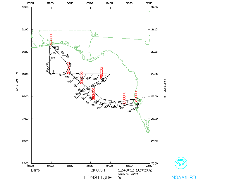
N42RF departed MacDill AFB at 2246 UTC and leveled off at 7,000 feet MSL on a departure heading towards the IP (Cigar, on the airways chart). At 2310 UTC the radars, both Lower Fuselage (LF) and Tail (TA), were being attended to by the technicians onboard the aircraft. Upon arrival at Cigar at 2313 UTC the aircraft turned towards the center of TS Barry on a track of 309° true. At 2313:56 an AXBT and GPS dropwindsonde were released recording a 10m wind of 20 knots, SST of 28.5°C and a mixed layer depth (MLD) of approximately 25 m. In this area an outer convective rainband with heavy precipitation was observed.
Continuing along the track towards the center of TS Barry, two additional drop (AXBT and sonde) locations were planned with the third to be released into the center of TS Barry. At 2321 UTC the LF and TA radars were up and running. At 2325:08 UTC an AXBT and sonde were released. The area was clear of rainbands with a scattered deck below and overcast CDO above. The 10m wind was 30 knots from the sonde, a SST of 29°C, and the MLD of 30m from the AXBT. At about 2325 UTC both the LF and TA radars were down and being attended to by Sean McMillan.
The third drop location, within 40nm of TS Barry along our NW track, occurred at 2334:44 UTC with a rainband observed about 10nm to the west. The sonde had late winds as well as no temperature or humidity measurements. The AXBT measured a SST of 29°C and a MLD of 25m. At 2339 UTC the Flight Director made one course correction towards the geometric center, depicted on the nose radar, of TS Barry.
At 2345 UTC the Flight Director announced that the SFMR was down and not expected to be working for the duration of the flight. At this time, our course correction was taking us about 10nm to the east of the wind/pressure center of TS Barry. At 2348:25 UTC an AXBT and sonde were released into a pronounced rainband about 15nm to the NE of the center of TS Barry. The sonde measured a 10m wind of 60 knots and the AXBT measured a SST of 30.5°C and a MLD of 25m. The center of TS Barry, determined by nose radar, was located about 29° 34' N 86° 15' W which was collaborated by a TEAL aircraft. The center of TS Barry was further north than was expected for the 0000 UTC forecast position.
With the SFMR and both LF and TA radars inoperative the decision was made to continue along our previously planned track and report the equipment status to CARCAH and AOC to determine the disposition of the mission. Continuing on our NW track towards the coastline, at 0001 UTC the aircraft was turned due south to track down the west side of TS Barry. Since TS Barry was about 30nm north of the anticipated location the decision was made to continue south to our originally drawn eastward leg along the 29°N parallel. At 0018 UTC the aircraft was turned toward the east along 29°N with two planned drop locations evenly spaced along the eastern edge of this leg. At 0030 UTC the aircraft passed approximately 30nm south of TS Barry. At 0042:53 UTC both a sonde and AXBT were released. The sonde recorded a 10m wind of 34 knots and the AXBT recorded a SST of 29°C. At this time, the Flight Director announced that the mission could continue until further clarification from CARCAH was received after 0100 UTC. At 0054:42 UTC the sixth combined drop, sonde and AXBT, were accomplished to the SE of TS Barry. Another sonde was released at 0056:17 UTC to back up the first sonde released two minutes prior. The recorded 10m wind was 18 knots and the SST was 29.5°C. Table 1 and Table 2 list the sonde and AXBT reference data.
At 0105 UTC, N42RF was released from all responsibility by CARCAH and the decision was made to take the "most expeditious course" back to MacDill AFB. At 0117 UTC the aircraft turned towards the airways point Cigar, no further drops were completed. At 0200 UTC, about 6 minutes before landing, the LF and TA radars were up and running. Peter Dodge reported that the sweeps appeared clean and "noise free."
ACKNOWLEDGEMENTS:
Tom Shepherd and Carl Newman responded quickly and with forethought in their roles as the Flight Director and Navigator, respectively. Sean McMillan spent the entire flight troubleshooting the LF and TA radars pinpointing the problem to the Digital Signal Processor or cabling, neither of which a spare was available onboard. Tony Castells bore the brunt of the mission answering questions from everyone as to the status of the SFMR. Unfortunately, with the problems he encountered with his computers, he was not able to troubleshoot the problem (s) in the air.
Mike Black and Peter Dodge provided invaluable assistance throughout the entire evolution of this mission. In particular, Mike Black designed the "last minute" atmospheric/oceanographic mission on top of the alpha pattern and also determined in real time the specific release locations to take advantage of particular atmospheric phenomena. Peter Dodge made prior arrangements with the NWS WSR-88D sites along the Gulf Coast.
The AOC pursuit of SATCOM communications was admirable. Both John Adler and Jeff Smith were testing out different SATCOM capabilities while in-flight with reportedly good success and high hopes for the future.
PROBLEMS:
The tasking by the NHC for the SFMR surface winds on N42RF was handled by AOC and HRD admirably despite the short-notice, the reduced HRD personnel on hand to accomplish the preparation and execution, and the insufficient time to test the equipment onboard N42RF, beforehand. The LF and TA radars were inoperative throughout most of the flight and the SFMR was inoperative after working for the first 30 minutes of the mission. Additionally, one sonde was missing temperature and humidity measurements, which was from a batch of defective sondes previously encountered by the NOAA G-IV aircraft. Because of reported pylon crack/repairs, the cloud physics probes were not installed.
Unknown during the mission, the data stream from the NMC server to HRD and NHC was inoperative. The HRD workstation was running smoothly with no known problems reported.
| # | Serial # | Time (Z) | Lat (°) | Lon (°) | Comments |
| 1 | 003515064 | 221356 | 27.8 | 84.4 | Outer rainband |
| 2 | 003515072 | 232508 | 28.3 | 85.1 | Between rainbands |
| 3 | 003515071 | 233444 | 28.8 | 85.7 | No Temp/Hum, late winds |
| 4 | 991845367 | 234825 | 29.6 | 85.3 | Eyewall |
| 5 | 003248005 | 004253 | 29.0 | 85.0 | SE of TS Barry |
| 6 | 003475099 | 005442 | 28.9 | 84.0 | - |
| 7 | 003475092 | 005617 | 28.9 | 84.1 | - |
| # | Time (Z) | Lat (°) | Lon (°) |
| 1 | 2314 | 27.9 | 84.3 |
| 2 | 2326 | 28.5 | 85.3 |
| 3 | 2335 | 28.9 | 85.9 |
| 4 | 2348 | ---- | ---- |
| 5 | 0042 | ---- | ---- |
| 6 | 0054 | ---- | ---- |
Last Updated August 17, 2001