INDIAN OCEAN ONE-TIME HYDROGRAPHY (WORLD OCEAN CIRCULATION EXPERIMENT)
Principal Investigator:
Dr. Molly O'Neil Baringer, AOML
Dr. Lynne D. Talley, SCRIPPS
Collaborating scientist(s):
Dr. Peter Hacker, Univ. Hawaii
Dr. Eric Firing, Univ. Hawaii
Objective:
As part of the WOCE one time survey of the Indian Ocean, high quality
hydrographic, Acoustic Doppler Current Profiler (ADCP) and chemistry data
were collected along a section
through the center of the Central Indian Basin and a repeat of the section
sampling the northward flow of deep water West of Australia.
Rationale:
The upper ocean circulation in the Indian Ocean
is dominated by the monsoon in the
tropics and a classical southern hemisphere subtropical gyre at
latitudes farther south.
The depth of monsoonal effects is not known. Coordination of
the high quality I8N data with tracers which we collect with the
repeated and direct velocity measurements of Schott (off the coast of
Sri Lanka) and Molinari (repeat I8N) will help define the depth
penetration of the monsoon reversals.
The intermediate and abyssal circulation in the
Central Indian Basin has been studied only sketchily, and the sources,
sinks and budgets of deep water will be explored with the new stations
from this and the other WHP cruises which cross it.
The deep circulation is overwhelmingly
constrained by the many mid-ocean ridges which criss-cross the Indian
Ocean.
In this section we examine the possible source of deep water for the
Central Indian basin from the West Australian basin across the saddle
in the Ninetyeast Ridge near 29 S.
Since the overall upwelling rate from the abyss to the
thermocline north of 30S appears to be much greater than in the
Pacific Ocean, the obvious question is where most of the enhanced
upwelling occurs and whether it is primarily linked to the monsoon and
equator or to the complex deep topography.
The 1995 repetition of the eastern part of I5E is meant to
determine if there were changes in the properties of waters flowing
into and out of the West Australia Basin. The biggest differences might
be expected in the upper ocean water masses, including the Subantarctic
Mode Water (SAMW) and
Antarctic Intermediate Water (AAIW);
a shift in deep properties, if found, would be more remarkable.
Method:
R/V Knorr departed Colombo, Sri Lanka on March 10, 1995, and arrived
in Fremantle, Australia on April 15, 1995 to carry out its third WOCE
hydrographic leg in the Indian Ocean. Basic technical support was
provided by Scripps Institution of Oceanography's Oceanographic Data
Facility. ADCP operations were carried out by U. Hawaii (Firing). The
basic sampling program was accomplished very smoothly. The full cruise
report can be obtained from the principal investigators.
The cruise track is shown in
figure 1.
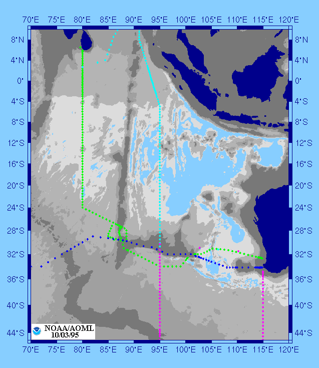 The latter portion was a nominal repeat of the
1987 section (Toole and Warren, 1993). The goals of the sampling were
to obtain a section through the center of the Central Indian Basin,
and to repeat the crossing of the northward flow of deep water just to
the west of Australia. Particular attention was paid to a potential
source of deep water for the Central Indian Basin, through a sill in
the NinetyEast Ridge, located at about 28S. It was also possible to
deviate from the 32S section, and sample in the deep water south of
Broken Ridge instead of along the top of the ridge. Between Broken
Ridge and Australia we chose to move the section slightly north of the
original position of I5E in order to resolve whether the deep flow
splits around Dirck Hartog Ridge.
The latter portion was a nominal repeat of the
1987 section (Toole and Warren, 1993). The goals of the sampling were
to obtain a section through the center of the Central Indian Basin,
and to repeat the crossing of the northward flow of deep water just to
the west of Australia. Particular attention was paid to a potential
source of deep water for the Central Indian Basin, through a sill in
the NinetyEast Ridge, located at about 28S. It was also possible to
deviate from the 32S section, and sample in the deep water south of
Broken Ridge instead of along the top of the ridge. Between Broken
Ridge and Australia we chose to move the section slightly north of the
original position of I5E in order to resolve whether the deep flow
splits around Dirck Hartog Ridge.
Accomplishment:
All stations were to within 10 meters of the bottom and included a
36-bottle rosette/CTD cast with lowered ADCP. A shipmounted ADCP was
operated throughout. Basic station spacing was 30 nm, and was reduced
at the equator, Sri Lankan and Australian coasts and crossings of the
NinetyEast and Broken Ridges. The CTD data stream consisted of
elapsed time, pressure, two temperature channels, conductivity,
oxygen, altimeter and transmissometer signals. Water samples were
collected for analyses of salt, oxygen, silica, phosphate, nitrate and
nitrite on all stations and of CFC- 11, CFC-12, carbon tetrachloride,
helium-3, helium-4, tritium, AMS C14, pCO2, total dissolved inorganic
carbon, alkalinity, and barium on selected stations.
Preliminary results reported in Talley and Baringer (1995) show
the very fresh water (<33.3 off Sri Lanka and <34.2 at 5S) originating
in the Bay of Bengal is evident at the surface, extending southward
from Sri Lanka to a front at 10S
(Figure 2).
 Below the fresh surface water lies
an intense halocline: 1 psu change in 30 meters. The saline water
(>35.3) just below the halocline is of Arabian Sea origin.
The temperature, salinity and density fields all indicate the
existence of a well-defined equatorial undercurrent centered at about
80 meters on this March section, in accord with climatology and
results of current meter arrays near this location (Knox and Anderson,
1985; Schott et al., 1994). The surface countercurrent has velocities
of about 70 cm/sec based on ADCP measurements. The equatorial
currents are clearly confined between fronts at 4N and 4S, and the low
salinity surface water has higher values than to the north and south
of this equatorial channel; the halocline is also more intense and
both suggest equatorial upwelling.
Below the fresh surface water lies
an intense halocline: 1 psu change in 30 meters. The saline water
(>35.3) just below the halocline is of Arabian Sea origin.
The temperature, salinity and density fields all indicate the
existence of a well-defined equatorial undercurrent centered at about
80 meters on this March section, in accord with climatology and
results of current meter arrays near this location (Knox and Anderson,
1985; Schott et al., 1994). The surface countercurrent has velocities
of about 70 cm/sec based on ADCP measurements. The equatorial
currents are clearly confined between fronts at 4N and 4S, and the low
salinity surface water has higher values than to the north and south
of this equatorial channel; the halocline is also more intense and
both suggest equatorial upwelling.
One of the most striking features on the section is the front at 10S
which separates the tropical waters from those of Indonesian
throughflow origin
(Figure 3).
This jet lies between 10 and 14S and appears to
extend almost exactly zonally westward from Java, carrying a
surface-to-intermediate depth layer of relatively fresh water,
although not as fresh as the Bay of Bengal water at the surface.
Oxygen and nutrients in the jet are similar to those of the tropical
Indian Ocean
One of the primary purposes of the WHP Indian Ocean
expedition is to determine the fate of the deep water which
enters from the south.
The Central Indian Basin is among the most removed from the
deep water source in the south since its bottommost water is
fed from the east across the Ninety-East Ridge, especially across
the sill near 11S (Warren,
1981).
 Our section down the
middle of the basin confirms the importance of the 11S sill
compared with the others. By far the largest puddle of
water at 80E with temperature less than 1C
(Figure 4)
is centered at 9S
with the largest geostrophic shear signature there,
indicating a source which is most likely to be the 11S sill.
A secondary bottom puddle of cold water lies centered at
18S; this is probably a southward
extension of the 11S bottom water (Warren, 1982).
Our section down the
middle of the basin confirms the importance of the 11S sill
compared with the others. By far the largest puddle of
water at 80E with temperature less than 1C
(Figure 4)
is centered at 9S
with the largest geostrophic shear signature there,
indicating a source which is most likely to be the 11S sill.
A secondary bottom puddle of cold water lies centered at
18S; this is probably a southward
extension of the 11S bottom water (Warren, 1982).
The deep water lying above the bottom water does not follow
such a circuitous route from the south, but rather enters
the Central Indian Basin directly across a saddle at about
35S. This section shows some evidence
for the input of this deep water, which is marked
by high salinity and high oxygen, centered at 2500-3500
meters
(Figure 5).
Our cruise timing permitted sampling the 28S sill with three small
sections. We found clear evidence of the westward flow of bottom
water into the Central Indian Basin, where it turns to the
south.
The properties of this layer clearly indicate an origin east of the
Ninety-East Ridge and north of Broken Plateau. The layer is colder
than 1.2C, fresher than 34.725psu and denser than 45.89 sigma 4. The
net transport appears to be about 2 to 2.5 Sv.
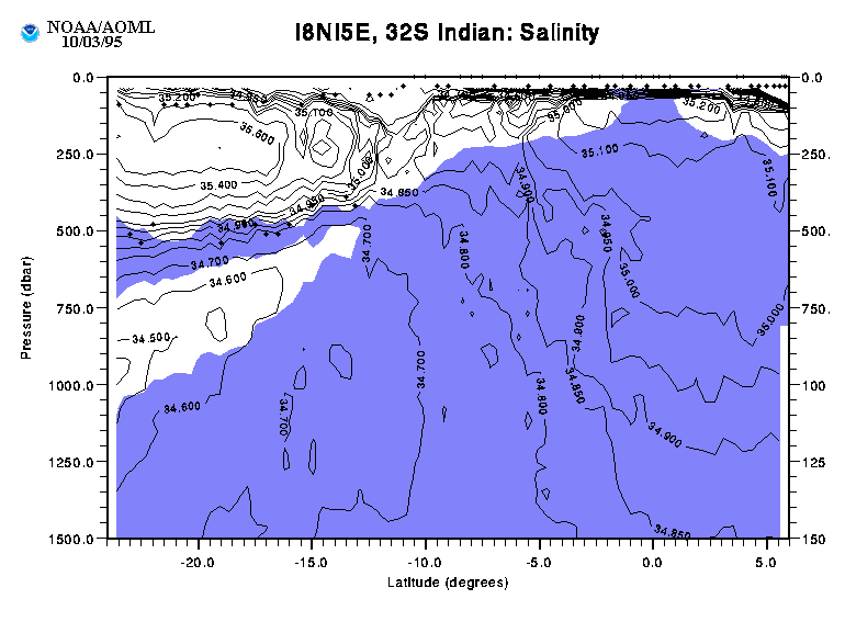
The eastward leg of our cruise crisscrossed the 1987 section at about
32S (Toole and Warren, 1993).
the 1995 section shows a net northward
flow +5.2 Sv below 2000 dbar consisting of +6.6 northward flow in the
boundary current and -1.4 Sv southward flow in the interior
(Figure 6).
Toole and Warren (1991) and Warren (1981) both obtained a net
northward flow of 6 Sv into the West Australian Basin consisting of 7
Sv in the boundary current and -1 Sv southward return flow (see Figure
3 for the comparison to Toole and Warren's (1991) transport). The
general location and magnitude of the deep flows are remarkably
similar.
Key references:
Chereskin, T.K., W.D. Wilson, H.L. Bryden, A. Ffield, and
J. Morrison, 1997. Observations of the Ekman balance at 8°30'N
int he Arabin Sea during the 1995 southwest monsoon,
Geophysical Research Letters, 24 (21), 2541-2544.
Ffield, A., 1997. GRL special section: WOCE Indian Ocean expedition,
Geophysical Research Letters, 24 (21), 2539-2540.
Ffield, A., J. Toole, and D. Wilson, 1997. Seasonal Circulation
in the South Indian Ocean,
Geophysical Research Letters, 24 (21), 2773-2776.
Gordon, A.L., S. Ma, D.B. Olson, P. Hacker, A. Ffield, L.D. Talley,
D. Wilson, M.O. Baringer, 1997. Advection and Diffusion of
Indonesian Throughflow within the Indian Ocean South Equatorial Current,
Geophysical Research Letters, 24, 2573.
McCarthy, M.C., L.D. Talley, and M.O. Baringer, 1997.
Deep Upwelling and Diffusivity in the Southern Central Indian Basin,
Geophysical Research Letters, 24 (21), 2801-2804.
Talley, L. D. and M. O. Baringer, 1995.
Preliminary results from WHP Sections I8N/I5E in the Central Indian Ocean.
WOCE Newsletter, 21, 35-38.
Talley, L. D. and M. O. Baringer, 1997.
Preliminary results from WHP Sections I8N/I5E in the Central Indian Ocean.
Geophysical Research Letters, 24 (21), 2789-2792.
Toole, J. M. and B. A. Warren, 1993. A hydrographic section across the subtropical South Indian
Ocean. Deep-Sea Research, 40 (10), 1973-2019.
Warren, B.A., 1981. Deep circulation of the World Ocean.
In Evolution of Physical Oceanography, MIT Press, 6-41.
Warren, B.A., 1982. The deep water of the Central Indian
Basin. J. Mar. Res., 42 (Suppl)., 823-860.
Click here to return to the AOML project overview page.
Click here to
return to the Implement Seasonal to
Interannual Climate Forcasts page.