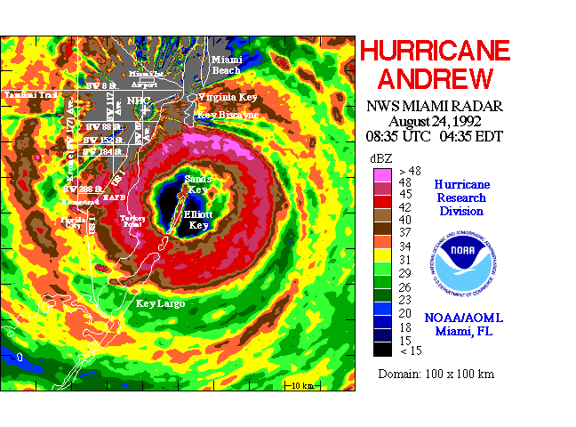
The summers of 1995 and 1996 were the most active consecutive hurricane seasons on record. Media coverage was intense. Watching a hurricane on television is abstract, but actually surviving a hurricane landfall is all too real--as the citizens of Miami discoverd when Hurricane Andrew came booming ashore in 1992. Andrew--the most expensive hurricane to strike the United States--destroyed 27 billion dollars worth of property in this community, but killed only 15 people by direct force of wind and water. Human casualties were extraordinarily light because the storm caused little flooding in populated areas and the National Hurricane Center forecast the storm track accurately. Good forecasts offer both motivation to act and time to prepare for the event. Intelligent preparation can reduce human and material losses, even though most property and many people cannot be evacuated from the path of the storm.
Hurricanes can be deadly and expensive. Before the 1940s when warnings were almost non-existent, hurricanes caused the deaths of thousands of people in the U.S. Even now in developing nations, where warnings may not always be timely or accurate and evacuations are difficult, hundreds of thousands of people died in a single tropical cyclone landfall as recently as 1970. As warnings in the U.S. improved, loss of life declined but monetary losses continued to increase. According to the National Climate Data Center, hurricanes caused six of the eleven weather disasters in the 1980s and early 1990s that cost the U.S. economy more than a billion dollars.
What causes these extraordinary storms? What determines the paths that they follow? How do they strengthen and grow?
A schematic radar image shows the essential structure of a hurricane: a clear eye enclosed by a ring of clouds, which is in turn surrounded by inward spiraling bands of convection. These features are common to all tropical cyclones. Hurricanes take their circular shape from the orbits of air moving in gradient balance around the low atmospheric pressure at the vortex center.
A cross section of a hurricne in the radius-height plane shows that the primary swirling flow is sustained by a radial and vertical secondary circulation. Under the influence of friction, the counter-clockwise spiraling air near the surface converges toward the lower pressure and rises around the eye in cumulus clouds. Although the inflowing air looses angular momentum to the sea, it gains heat stored as water vapor. The vapor condenses in the updrafts, releasing the stored heat and causing intense precipitation. At 2-6 km altitude the updrafts entrain additional air, which is replaced by horizontal convergence that supplies both mass and angular momentum needed to spin up the wind. The updrafts may rise as high as 16 kilometers where the air flows outward to the environment. The source of the storm's energy is heat drawn from the warm sea surface at 28-29°C and returned to the surrounding upper atmosphere at -70°C.
In the center of the hurricane is the cloud-free eye. The clouds that enclose the eye form the eyewall. These clouds draw air from the eye at low levels, causing descent, drying, and warming inside the eye. As the air warms, it becomes less dense so surface pressure must fall. The clouds also draw air inward from outside the eye, thus concentrating the counter-clockwise rotation and increasing the swirling winds. In a hurricane, the strongest winds are near the surface and lie just outside the eyewall.
Hurricanes' motion is largely governed by the winds that surround them. In effect, the storm is simply carried downstream by the average environmental wind. When a hurricane is on the weather map, the question that everyone wants answered is really not where is it going, but how close will it be to me, my home, my family, my workplace? People who live in hurricane-prone areas are acutely aware of the cost and effort required to prepare for a landfall; however, intelligent preparation requires accurate and timely information as well. This is where research can pay big dividends. Hurricane conditions typically affect a swath of about 100 nautical miles wide; the error in a 24-hour forecast also is about 100 nautical miles. Thus, a prudent forecaster expects to raise warnings on 300 nautical miles of coastline: 100 nautical miles that actually feel the hurricane and 100 nautical miles on either side to allow for the forecast error.
Warnings are expensive, even though they are essential for protecting people and property. The economic cost of raising a warning, in terms of lost productivity, safeguarding homes and industries, evacuation of aircraft and vessels, and canceled beachfront vacations averages $0.66M per mile. In individual cases, the cost depends upon the amount of coastal development. If a major city, such as Miami or New Orleans, lies in the warning area, it escalates dramatically. Sometimes, as happened in Hurricane Emily of 1993, models and observations combine to give forecasters particularly clear insight into the meteorological situation, so that they can exclude large sections of coastline, perhaps hundreds of miles long, from the warning area and save the economy as much as $100M.
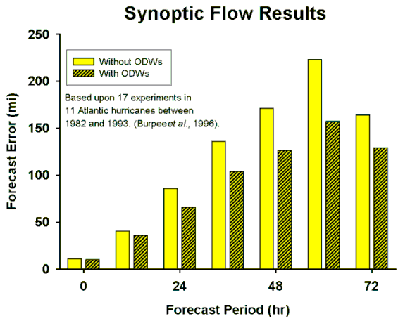
Over the last 20 years, the decrease in forecast error has averaged about 1% per year, largely because of improved computer models. In fact, the models are now better than the knowledge of the "initial condition," the state of the atmosphere at the start of a prediction calculation. Research at AOML has demonstrated that special observations around hurricanes can realize another 16-30% reduction in the error. If the more accurate forecasts translate into reduced warning areas, savings on the order of $10 million of overwarning costs per hurricane landfall are possible. This dramatic result recognizes that hurricane motion is controlled by the state of the surrounding atmosphere, so that forecasts based upon accurate and timely measurements of that state are themselves more accurate. In these experiments, the atmospheric state was measured by omega dropwindsondes that were deployed by the NOAA WP-3D research aircraft. Released from an altitude of 5 to 7 kilometers, the sondes measured pressure, wind, temperature, and humidity as they fell to the sea on parachutes. Release patterns encircled the storm and reached more than 1,000 kilometers from the center. Aboard the aircraft, meteorologists processed the data and transmitted it to the National Centers for Environmental Prediction, where it was analyzed and used to initialize numerical models. The cost of two P-3 flights and the dropsondes was about $100,000--less than one percent of the savings from reduced overwarning. More widespread and efficient observations of this kind are the primary reason that NOAA commissioned a new Gulfstream IV jet that flew synoptic flow missions successfully during the 1997 hurricane seasons. The obsolete Omega Dropwindsondes have now been replaced by more accurate GPS sondes that offer faster fall speed and higher resolution. As part of the upgrade, new, faster in-flight processing and data-visualization software was developed. These improvements promise a technical and scientific revolution in hurricane track forecasting.
As the experience in Hurricane Opal of 1995 illustrates, intensity predictions compare poorly to the skill exhibited by track forecasts. Forecasters at the National Hurricane Center use a half dozen models to guide track forecasts. For intensity forecasting, only one model has been available (until recently) and that was based on climatology and persistence. These rudimentary tools reflect the challenge of forecasting intensity. It is a difficult problem and it is the focus of continuing research. AOML scientists recently developed a more complete statistical hurricane intensity prediction model that includes the effects of variations in sea-surface temperature and upper tropospheric turbulent transports. Although this model is available in real time and has had some success, there is still much to be learned before accurate intensity forecasts become routine.
Hurricane intensity is reckoned on the Saffir-Simpson scale; one (minimal) to five (catastrophic). A typical hurricane intensifies slowly, remaining in category one or reaching two or even three before it runs ashore or drifts north out of the tropics. The strongest hurricanes, such as Andrew in 1992, intensify rapidly and go from category one or two to category four or five in just a day or two. The process that initiates rapid intensification begins with atmospheric waves that form on the hurricane vortex at altitudes of greater than 12 kilometers (where the new jet will fly). These waves result from interaction with nearby low pressure systems. The waves, through a complicated chain of cause and effect, intensify the cumulus clouds that are involved in the energy conversion mechanisms of a hurricane. Recent theoretical work and the data collected during AOML research flights into Hurricane Olivia point the way to a more accurate understanding of rapid intensification and ultimately to better forecasting of the intensity of the most dangerous hurricanes.
AOML research has produced accurate, timely maps of surface winds in hurricanes. These maps, which are based upon aircraft observations, are invaluable for preparation of forecasts before landfall and for damage assessment after landfall. The maps are now prepared routinely whenever a hurricane threatens land. A particularly important application of these products is the rapid identification of the most severely devastated areas; this enables disaster response teams to reach them quickly.
Can human intervention diminish the force of a hurricane? From the mid-1960s through the early 1980s NOAA actively pursued Project STORMFURY, a program of experimental hurricane modification. The general strategy was to reduce the intensity of the storm by cloud seeding. The seeding, it was argued, would stimulate the formation of a new eyewall that would surround the existing eyewall. The new eyewall would contract, strangling the old eyewall and reducing the intensity of the hurricane. However, research carried out at AOML showed clearly that these "concentric eyewalls" happened often in unmodified hurricanes, thus casting doubt on the seemingly positive results of seeding in earlier experimentation. Hurricane Luis provides an example of this behavior. Moreover, observations showed that hurricanes contain little of the supercooled water necessary for cloud seeding to work. We now believe that there is no practical way to reduce the intensity of hurricanes artificially. The only remaining course is to provide the best forecasts possible and urge that everyone heed the warnings. These great storms must be treated with respect.
Click here to look at Climate Processes.
Last modified: Tuesday, 24-Feb-98 11:35:10 EDT.
Please report any problems to webmaster.